. 2016 Nov 9;11(11):e0164979.
doi: 10.1371/journal.pone.0164979. eCollection 2016.

Smartphone-Based Distributed Data Collection Enables Rapid Assessment of Shorebird Habitat Suitability

Affiliations

Smartphone-Based Distributed Data Collection Enables Rapid Assessment of Shorebird Habitat Suitability

E Robert Thieler et al. PLoS One. .

Abstract

Understanding and managing dynamic coastal landscapes for beach-dependent species requires biological and geological data across the range of relevant environments and habitats. It is difficult to acquire such information; data often have limited focus due to resource constraints, are collected by non-specialists, or lack observational uniformity. We developed an open-source smartphone application called iPlover that addresses these difficulties in collecting biogeomorphic information at piping plover (Charadrius melodus) nest sites on coastal beaches. This paper describes iPlover development and evaluates data quality and utility following two years of collection (n = 1799 data points over 1500 km of coast between Maine and North Carolina, USA). We found strong agreement between field user and expert assessments and high model skill when data were used for habitat suitability prediction. Methods used here to develop and deploy a distributed data collection system have broad applicability to interdisciplinary environmental monitoring and modeling.


Conflict of interest statement

The authors have declared that no competing interests exist.

Figures

Fig 1
Fig 1. Barrier islands are a principal habitat type in the U.S. Atlantic coast piping plover breeding range.
(A) Oblique aerial photograph of southwestern Ocracoke Island, North Carolina, showing open-ocean sandy beach (right), dunes, backbarrier bay, and various types of dune, shrub, forest, and marsh vegetation. (U.S. Geological Survey/photo by Karen L.M. Morgan.) (B) The piping plover (C. melodus), a federally listed beach-nesting shorebird. (U.S. Fish and Wildlife Service/photo by Gene Nieminen.)
Fig 2
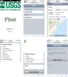
Fig 2. Screenshots showing the iPlover web application interface used during summer 2014.
(A) Splash screen showing application name and version. (B) Home page with options to record a new observation ("nest site") or upload existing data. (C) Upper portion of the New Nest Site data entry page, showing site identification entry, photo capture button, and location functionality. (D) Middle portion of the New Nest Site data entry page, showing radio button selection options for the site’s geomorphic setting. (E) Lower portion of the New Nest Site data entry page, showing radio button selection options for vegetation density, the notes field, and "save" button. (F) Upload data page, showing number of sampling data points currently stored on the device, a button to initiate data transfer, and a progress bar to indicate upload status.
Fig 3
Fig 3. Map showing the locations of iPlover mobile application data collection during summer 2014.
Red dots indicate recorded observations (n = 574). (Basemap from GSHHG, https://www.ngdc.noaa.gov/mgg/shorelines/gshhs.html.)
Fig 4
Fig 4. Nest site photos collected using the iPlover web app, showing representative environments.
(A) Shell-dominated washover deposit. (B) Moderately vegetated low dune. (C) Open beach with plover nest protected by a wire mesh predator exclosure. Nest site photos were taken by project participants and used for ground-truthing by subject-matter experts.
Fig 5
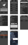
Fig 5. Screenshots showing the iPlover interface developed for native iOS and Android applications.
(A) Home page with login screen. (B) Main tasks screen. (C) Upper portion of the New Nest Site data entry page, showing site identification entry, photograph button, location information, and radio button selection options for the site geomorphic setting. (D) Middle portion of the New Nest Site data entry page, showing radio button selection options for substrate and vegetation type. (E) Lower portion of the New Nest Site data entry page, showing radio button selection options for vegetation density, calendar picker for estimated nest initiation date, notes field, and Save Nest Data button. (F) Synchronize data screen, showing number of sites currently stored on the device, button to initiate data transfer, and progress bar to indicate upload status. (G) Edit Nest Sites screen, showing data records available for editing. Records with orange striping indicate data that have not yet been synchronized with the central database. (H) Map Nest Sites screen, showing data records on a map. Tapping a data point produces a pop-up window with the site identifier and an option to edit the data record.
Fig 6
Fig 6. Plot showing spatial difference between global navigation satellite system receiver (GNSS)- and smartphone-derived data points on coastal beaches.
Black open circles show the distance between each GNSS observation and the corresponding iPlover observation (S1 Table). The black square is the average distance between the GNSS and the smartphone for the 44 data points, and the gray circle is the one-sigma range around that average distance.

References

    1. Wong PP, Losada IJ, Gattuso JP, Hinkel J, Khattabi A, McInnes KL, et al. Coastal systems and low-lying areas In: Field CB, Barros VR, Dokken DJ, Mach KJ, Mastrandrea MD, Bilir TE, et al., editors. Climate Change 2014: Impacts, Adaptation, and Vulnerability Part A: Global and Sectoral Aspects Contribution of Working Group II to the Fifth Assessment Report of the Intergovernmental Panel of Climate Change. Cambridge, United Kingdom and New York, NY, USA: Cambridge University Press; 2014. p. 361–409.
    1. Moser SC, Davidson MA, Kirshen P, Mulvaney P, Murley JF, Neumann JE, et al. Coastal zone development and ecosystems In: Melillo JM, Richmond TC, Yohe GW, editors. Climate Change Impacts in the United States: The Third National Climate Assessment. Washington, D.C.: U.S. Global Change Research Program; 2014. p. 579–618.
    1. Galbraith H, DesRochers DW, Brown S, Reed JM. Predicting vulnerabilities of North American shorebirds to climate change. PLoS ONE. 2014;9(9):e108899 10.1371/journal.pone.0108899 - DOI - PMC - PubMed
    1. U.S. Fish and Wildlife Service. Endangered and threatened wildlife and plants: determination of endangered and threatened status for the piping plover: final rule. Federal Register. 1985;50(238):50726–34.
    1. U.S. Fish and Wildlife Service. Preliminary 2012 Atlantic Coast Piping plover abundance and productivity estimates 2013 [15 September 2015]. Available from: http://www.fws.gov/northeast/pipingplover/pdf/preliminary2012_18April201....