

Space geodetic monitoring of engineered structures: The ongoing destabilization of the Mosul dam, Iraq
- PMID: 27922128
- PMCID: PMC5138637
- DOI: 10.1038/srep37408
Space geodetic monitoring of engineered structures: The ongoing destabilization of the Mosul dam, Iraq
Abstract
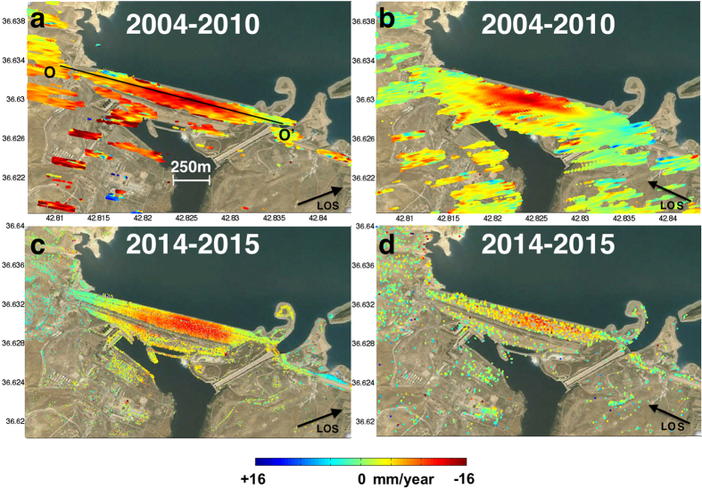
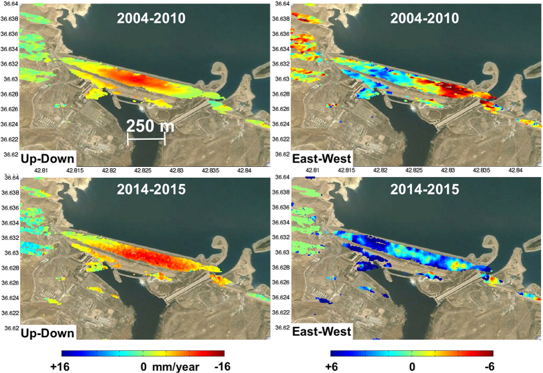
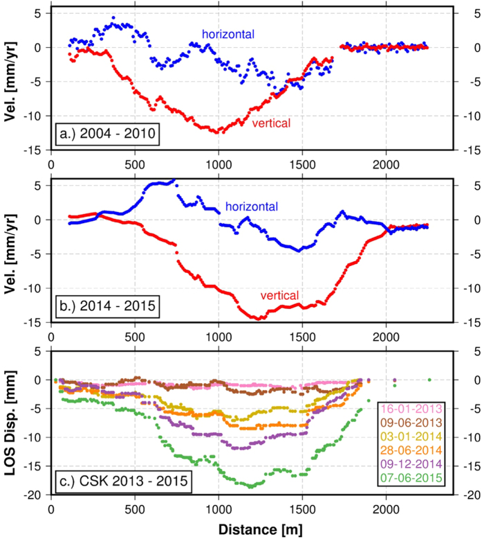
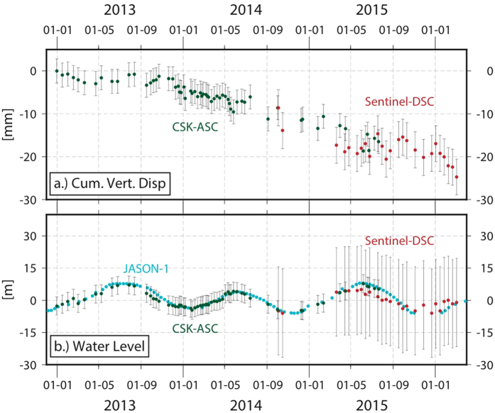
We present a detailed survey of the ongoing destabilization process of the Mosul dam. The dam is located on the Tigris river and is the biggest hydraulic structure in Iraq. From a geological point of view the dam foundation is poor due to a site geology formed by alternating strata of highly soluble materials including gypsum, anhydrite, marl and limestone. Here we present the first multi-sensor cumulative deformation map for the dam generated from space-based interferometric synthetic aperture radar measurements from the Italian constellation COSMO-SkyMed and the European sensor Sentinel-1a over the period 2014-2016 that we compare to an older dataset spanning 2004-2010 acquired with the European Envisat satellite. We found that deformation was rapid during 2004-2010, slowed in 2012-2014 and increased since August 2014 when grouting operations stopped due to the temporary capture of the dam by the self proclaimed Islamic State. We model the inferred deformation using a Markov chain Monte Carlo approach to solve for change in volume for simple tensile dislocations. Results from recent and historical geodetic datasets suggests that the volume dissolution rate remains constant when the equivalent volume of total concrete injected during re-grouting operations is included in the calculations.
Figures
References
-
- Bowen S. W. Office of the special Inspector General for Iraq Reconstruction. Relief and reconstruction funded work at Mosul dam Mosul, Iraq. (date of access: 16/03/2016). (http://cybercemetery.unt.edu/archive/sigir/20131001121159/http:/www.sigi... (2007).
-
- Milillo P. et al.. On the Synergistic Use of SAR Constellations’ Data Exploitation for Earth Science and Natural Hazard Response. IEEE JSTARS, 9(3), 1095–1100 (2016).
-
- Ferretti A., Prati C. & Rocca F. Nonlinear subsidence rate estimation using permanent scatterers in differential SAR interferometry. IEEE trans. Geo. Rem. Sens. 38(5), 2202–2212 (2000).
-
- Ferretti A., Prati C. & Rocca F. (2001). Permanent scatterers in SAR interferometry. IEEE Transactions on geoscience and remote sensing, 39(1), 8−20.Okada, Y. Surface deformation due to shear and tensile faults in a half-space. Bulletin of the seismological society of America, 75(4), 1135–1154 (1985).
-
- Kelley J. R. et al.. Geologic setting of Mosul Dam and its engineering implications. (date of access: 16/03/2016). (http://el.erdc.usace.army.mil/elpubs/pdf/tr07-10.pdf) (2007)
Publication types
LinkOut - more resources
Full Text Sources
Other Literature Sources
