

Fish Distribution and Habitat Complexity on Banks of the Strait of Sicily (Central Mediterranean Sea) from Remotely-Operated Vehicle (ROV) Explorations
- PMID: 27936221
- PMCID: PMC5147987
- DOI: 10.1371/journal.pone.0167809
Fish Distribution and Habitat Complexity on Banks of the Strait of Sicily (Central Mediterranean Sea) from Remotely-Operated Vehicle (ROV) Explorations
Abstract
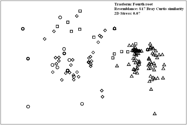
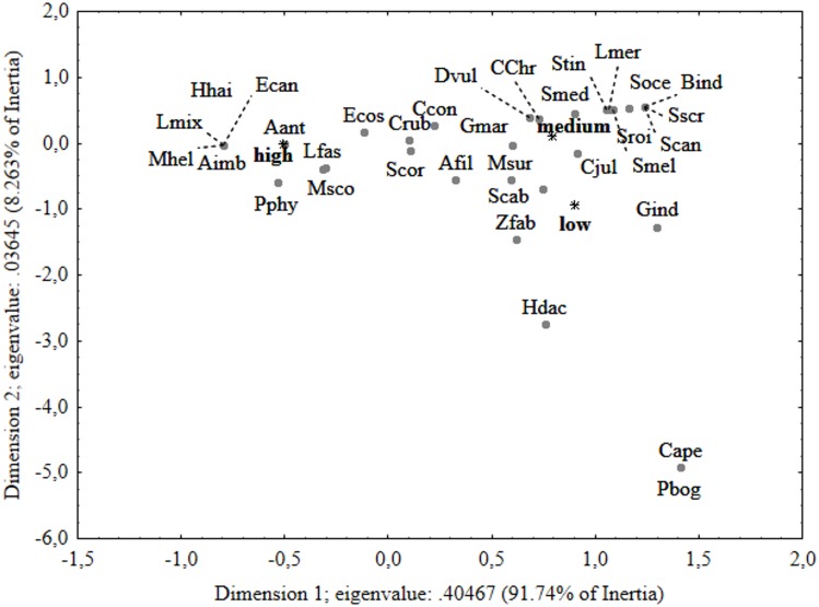
The Strait of Sicily was recognized internationally as an "Ecologically or Biologically Significant Area" by the Contracting Parties of the Convention on Biological Diversity in 2014. However, basic aspects of its fish diversity are still unknown and most of the information comes from traditional trawl surveys. This paper provides the first detailed description, using a Remotely Operated Vehicle (ROV), of the composition and depth distribution of the demersal fish assemblages found on banks of the Strait of Sicily and the related habitat complexity from 35 to 240 m depth. A total of 24 families and 52 fish species were recorded and depth was consistently associated with a significant proportion of the variation of the fish assemblage. The highest species richness was observed at the shallowest depth layer (0-50 m) and significantly decreased, remaining almost constant, in deeper layers. Similarly the highest abundance was recorded at 0-50 m, where C. julis represented the most abundant species, and decreased progressively throughout the whole depth gradient. Although the factor habitat complexity explained only a small proportion of the fish assemblage variation, significant differences among different degrees of habitat complexity were observed, together with a general positive trend for species richness and abundance with increasing habitat complexity. The ROV also allowed us to observe some rare or poorly known fish species such as Scorpaenodes arenai, Hyporthodus haifensis, Myliobatis aquila, Gadella maraldi, Epinephelus caninus and Lappanella fasciata. These findings show that banks serve as reservoirs for fish abundance and biodiversity and that immediate environmental conservation and management actions represent a priority not only for Italy but also for other countries which share the same area.
Conflict of interest statement
The authors have declared that no competing interests exist.
Figures


References
-
- Astraldi M, Gasparini GP, Gervasio L, Salusti E. Dense water dynamics along the Strait of Sicily (Mediterranean Sea). J Phys Oceanogr. 2001. December;31(12):3457–3475.
-
- Omrani H, Arsouze T, Béranger K, Boukthir M, Drobinski P, Lebeaupin-Brossier C, et al. Sensitivity of the sea circulation to the atmospheric forcing in the Sicily Channel. Prog Oceanogr. 2016. January 31;140:54–68.
-
- Civile D, Lodolo E, Caffau M, Baradello L, Ben-Avraham ZV. Anatomy of a submerged archipelago in the Sicilian Channel (central Mediterranean Sea). Geol Mag. 2016;153(01):160–78.
-
- Béranger K, Mortier L, Gasparini GP, Gervasio L, Astraldi M, Crépon M. The dynamics of the Sicily Strait: a comprehensive study from observations and models. Deep Sea Res Part 2 Top Stud Oceanogr. 2004. March 31;51(4):411–40.
-
- Lermusiaux PF, Robinson AR. Features of dominant mesoscale variability, circulation patterns and dynamics in the Strait of Sicily. Deep Sea Res Part 1 Oceanogr Res Pap. 2001. August 31;48(9):1953–97.
MeSH terms
LinkOut - more resources
Full Text Sources
Other Literature Sources
