Climatic implications on variations of Qehan Lake in the arid regions of Inner Mongolia during the recent five decades
- PMID: 27966191
- PMCID: PMC5155022
- DOI: 10.1007/s10661-016-5721-5
Climatic implications on variations of Qehan Lake in the arid regions of Inner Mongolia during the recent five decades
Abstract
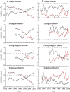
The Qehan Lake Basin (QLB) and its system of lakes are located in a marginal monsoon zone and are extremely sensitive to global climate change. In this paper, using aerial photographs from different periods, in addition to MSS, TM, and ETM images, and combining these with regional topographic maps, we analyze lake area changes from 1958 to 2010 and the relation between Qehan Lake (QL) and climate variability. Our results indicate that there was a relatively high lake level in 1959, when the area and volume of the lake were 118.9 km2 and 151.9 × 10⁶ m3, respectively, but this level was subject to a shrinking trend until 2010, when the lake area was only 28.1 km2, and the water volume was 41.1 × 10⁶ m3. West Qehan Lake (WQL) has experienced severe water shrinkage and lake level fluctuation. In 1958, WQL was 80.2 km2 in area and 124.1 × 10⁶ m3 in volume. However, due to a rapid decrease in precipitation and increases in both temperature and evaporation, it began to dry up in 2002. The WQL Water area decreased by 1.82 km2/a, and the lake level declined by 7 m during 1958-2002, so it became an ephemeral lake.
Keywords: Climatic change; Inner Mongolia; Lake level fluctuation; Semi-arid environment; Wetlands.
Figures


Similar articles
-
Monitoring land cover change and its dynamic mechanism on the Qehan Lake Basin, Inner Mongolia, North China, during 1977-2013.Environ Monit Assess. 2018 Mar 9;190(4):205. doi: 10.1007/s10661-018-6582-x. Environ Monit Assess. 2018. PMID: 29524013
-
Coupling reconstruction of atmospheric hydrological profile and dry-up risk prediction in a typical lake basin in arid area of China.Sci Rep. 2022 Apr 20;12(1):6535. doi: 10.1038/s41598-022-10284-y. Sci Rep. 2022. PMID: 35443769 Free PMC article.
-
Quantitative assessment of Urmia Lake water using spaceborne multisensor data and 3D modeling.Environ Monit Assess. 2017 Oct 18;189(11):572. doi: 10.1007/s10661-017-6308-5. Environ Monit Assess. 2017. PMID: 29046972
-
A review on the research progress of lake water volume estimation methods.J Environ Manage. 2022 Jul 15;314:115057. doi: 10.1016/j.jenvman.2022.115057. Epub 2022 Apr 19. J Environ Manage. 2022. PMID: 35452887 Review.
-
[Lake eutrophication modeling in considering climatic factors change: a review].Ying Yong Sheng Tai Xue Bao. 2012 Nov;23(11):3197-206. Ying Yong Sheng Tai Xue Bao. 2012. PMID: 23431809 Review. Chinese.
Cited by
-
Pollutant Photodegradation Affected by Evaporative Water Concentration in a Climate Change Scenario.Molecules. 2024 Jun 4;29(11):2655. doi: 10.3390/molecules29112655. Molecules. 2024. PMID: 38893529 Free PMC article.
-
Monitoring land cover change and its dynamic mechanism on the Qehan Lake Basin, Inner Mongolia, North China, during 1977-2013.Environ Monit Assess. 2018 Mar 9;190(4):205. doi: 10.1007/s10661-018-6582-x. Environ Monit Assess. 2018. PMID: 29524013
References
-
- Bian D, Li L, Wang W. The response of lake change to climate fluctuation in north Qinghai-Tibet Plateau in last 30 years. Journal of Geographical Sciences. 2009;19:131–142. doi: 10.1007/s11442-009-0131-z. - DOI
-
- Chen YN, Xu CC, Hao XM. Fifty-year climate change and its effect on annual runoff in the Tarim River Basin, China. Quaternary International. 2009;208:53–61. doi: 10.1016/j.quaint.2008.12.014. - DOI
-
- Davi NK, Jacoby GC, Curtis AE, Baatarbileg N. Extension of drought records for central Asia using tree rings: West-central Mongolia. Journal of Climate. 2006;19:288–299. doi: 10.1175/JCLI3621.1. - DOI
-
- Ding YH, Ren GY, Zhao ZC, Xu Y, Lou Y, Li QP, Zhang J. Detection, causes and projection of climate change over China: an overview of recent progress. Advances in Atmospheric Sciences. 2007;6:954–971. doi: 10.1007/s00376-007-0954-4. - DOI
MeSH terms
LinkOut - more resources
Full Text Sources
Other Literature Sources
Medical

