. 2016 Dec 27;113(52):14938-14943.
doi: 10.1073/pnas.1613169114. Epub 2016 Dec 15.

Present-day African analogue of a pre-European Amazonian floodplain fishery shows convergence in cultural niche construction

Affiliations

Present-day African analogue of a pre-European Amazonian floodplain fishery shows convergence in cultural niche construction

Doyle B McKey et al. Proc Natl Acad Sci U S A. .

Abstract

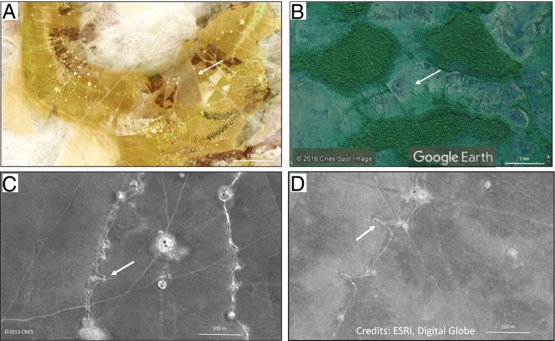
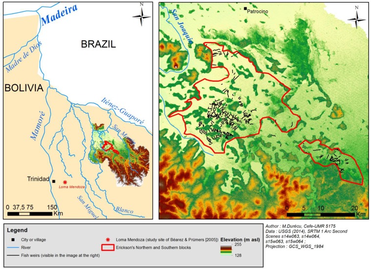
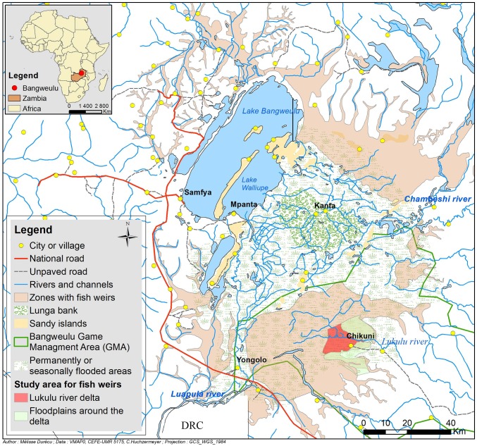
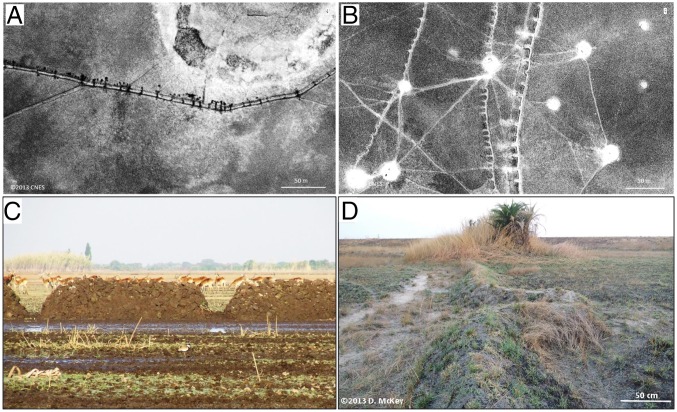
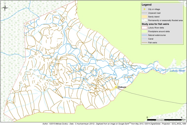
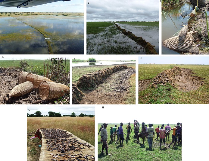
Erickson [Erickson CL (2000) Nature 408 (6809):190-193] interpreted features in seasonal floodplains in Bolivia's Beni savannas as vestiges of pre-European earthen fish weirs, postulating that they supported a productive, sustainable fishery that warranted cooperation in the construction and maintenance of perennial structures. His inferences were bold, because no close ethnographic analogues were known. A similar present-day Zambian fishery, documented here, appears strikingly convergent. The Zambian fishery supports Erickson's key inferences about the pre-European fishery: It allows sustained high harvest levels; weir construction and operation require cooperation; and weirs are inherited across generations. However, our comparison suggests that the pre-European system may not have entailed intensive management, as Erickson postulated. The Zambian fishery's sustainability is based on exploiting an assemblage dominated by species with life histories combining high fecundity, multiple reproductive cycles, and seasonal use of floodplains. As water rises, adults migrate from permanent watercourses into floodplains, through gaps in weirs, to feed and spawn. Juveniles grow and then migrate back to dry-season refuges as water falls. At that moment fishermen set traps in the gaps, harvesting large numbers of fish, mostly juveniles. In nature, most juveniles die during the first dry season, so that their harvest just before migration has limited impact on future populations, facilitating sustainability and the adoption of a fishery based on inherited perennial structures. South American floodplain fishes with similar life histories were the likely targets of the pre-European fishery. Convergence in floodplain fish strategies in these two regions in turn drove convergence in cultural niche construction.

Keywords: convergent evolution; cultural evolution; earthworks; historical ecology; tropical stream ecology.


Conflict of interest statement

The authors declare no conflict of interest.

Figures

Fig. 1.
Fig. 1.
Seasonal floodplain landscapes bearing large numbers of earthen fish weirs (white arrows). (A) The present-day fishery in the Bangweulu basin, Zambia, described in this study. Multispectral satellite image by the Pléiades sensor, 12°00′S, 29°42′E, September 17, 2013 (Copyright 2013, CNES, Distribution Airbus DS, all rights reserved). (B) The archaeological fishery in Bolivian Amazonia described by Erickson (1). Image from Google Earth V7.1.5.1557; 13°51′S, 63°19′W. (C) Fishways (white arrow) in weirs in the Bangweulu basin, Zambia. Multispectral satellite image by the Pléiades sensor, 12°00′S, 29°42′E, September 17, 2013 (Copyright 2013, CNES, Distribution Airbus DS, all rights reserved). (D) Vestiges of V-shaped structures (white arrow) in the archaeological fishery in Bolivia. Image (13°45′30′′, 63°18′’52′′W) from “World Imagery” layer of ArcGis. Source: ESRI, Digital Globe, satellite WorldView1, June 2008.
Fig. S1.
Fig. S1.
Fine-scale distribution of fish weirs in a zone within the Northern block described by Erickson (1). (AC) Comparison of Erickson’s original figure 4 based on aerial photographs (A) on a World Imagery (ArcGis) image of the identical area (B) and our photo-interpretation of this image (C). (A) Erickson’s figure 4 (1), reproduced with the original legend. Reprinted from ref. with permission from MacMillan Publishers Ltd. (B) World Imagery including the area depicted in A (within the white-bordered rectangle). Image available in the World Imagery layer of ArcGis; 13°48′S, 63°19′W; source: ESRI, Digital Globe, satellite WorldView1, June 2008. (C) Map of fish weirs and causeways, digitized from the image in B and based on our photo-interpretation. The image is presented at the same scale as the image in A, but note the difference in the scale given by Erickson in A and the scale in B and C based on World Imagery.
Fig. S2.
Fig. S2.
Localization of the archaeological fish weirs described by Erickson (1). (Left) The location of the San Joaquin floodplain in relation to that of the study site of Béarez and Prümers (3). (Right) A larger-scale image showing the location of fish weirs (nonexhaustive mapping using Google Earth imagery) in relation to topography. The mapped weirs are superimposed on an SRTM (Shuttle Radar Topography Mission, National Aeronautics and Space Administration) 1 Arc Second image of the region (49). The map shows that weirs are found in the lowest-lying parts of the two blocks.
Fig. 2.
Fig. 2.
Distribution of fish weirs in the seasonal floodplains of the Bangweulu basin, Zambia. See Methods and SI Text for sources and methods used to prepare the map.
Fig. 3.
Fig. 3.
Fishways, the simple gaps or V-shaped structures that are the characteristic features of earthen fish weirs in Bangweulu basin, Zambia, seen from the air (A and B) and on the ground (C and D. (A and C) Simple gap fishways. (A) Simple gap fishways seen from the air. Panchromatic satellite image by the Pléiades sensor, 12°02′S, 30°05′E, September 17, 2013 (Copyright 2013, CNES, Distribution Airbus DS, all rights reserved). (C) Simple gap fishways in a newly constructed weir in the Bangweulu basin. Behind the weir is a herd of black lechwe (Kobus leche smithemani). (Photograph copyright 2011, C.F.H.) (B and D) V-shaped fishways. (B) V-shaped fishways seen from the air. Panchromatic satellite image by the Pléiades sensor, 12°02′S, 30°09′E, September 17, 2013 (Copyright 2013, CNES, Distribution Airbus DS, all rights reserved). (D) V-shaped fishways seen from the ground. (Copyright 2013, D.M.)
Fig. S3.
Fig. S3.
Detailed map showing the distribution of fish weirs in a small part of the area shown in Fig. 2, the Lukulu delta, digitized from a Google Earth image taken in May 2012.
Fig. S4.
Fig. S4.
Rainfall seasonality in the areas occupied by the archaeological weir-based fishery (Baures region of Bolivia) and the present-day analogue (Bangweulu basin, Zambia). Data are from the Global Precipitation Climatology Centre (GPCC) database (www.dwd.de/EN/ourservices/gpcc/gpcc.htm).
Fig. S5.
Fig. S5.
Seasonal and interannual variation in flood level. (A) Baures region, Bolivia. Two sources of data were used to compile the graph. Data from the RA-2 altimeter aboard the ENVISAT satellite launched in 2002 [ENVISAT/RA-2 Geophysical Data Records (GDR) version V 2.1] were obtained from the Center for Topographic Studies of the Ocean and Hydrosphere (CTOH; ctoh.legos.obs-mip.fr). Data from the Atika altimeter aboard the Satellite with Argos and Altika (SARAL) satellite launched in 2013 (SARAL data, version IGDR-T) were obtained from the AVISO (Archiving, Validation and Interpretation of Satellite Oceanographic data; www.aviso.altimetry.fr/en/home). We used Virtual Altimetry Station (VALS) software (50) to process the data. (B) Lukulu delta, Bangweulu basin, Zambia. Data are from gauges established and observed by C.F.H.
Fig. S6.
Fig. S6.
Construction, maintenance, and use of earthen weirs in the Bangweulu weir fishery. (A and B) Weirs in action. (A) A long weir set with mosquito-net traps, seen from the air. (B) Weir showing the slightly deeper passageway for canoes on one side. (C and D) Types of traps placed at fishways. (C) A mono basket trap (traditional) and a mosquito-net trap (modern gear). (D) Mono baskets before the addition of trap valve. (E and F) Construction and maintenance of weirs. (E) A new weir, showing a newly constructed simple-gap fishway and the adjacent excavation channel. The height of new weirs can be up to 1.5 m. (F) An old weir maintained by the addition of new sods. (G) Fish harvested using weirs. Large numbers of fish, mostly juveniles, are captured during falling water in flooded savanna. (H) Cooperation and social coordination. A chipupila (center, with foot raised on an old weir) giving a “pep talk” to villagers preparing to begin work repairing an old weir. (All photographs Copyright 2011–2016, C.F.H.)

References

    1. Erickson CL. An artificial landscape-scale fishery in the Bolivian Amazon. Nature. 2000;408(6809):190–193. - PubMed
    1. Connaway JM. 2007. Fishweirs: A World Perspective with Emphasis on the Fishweirs of Mississippi. (Mississippi Department of Archives and History, Jackson, MS) Archaeological report no. 33.
    1. Béarez P, Prümers H. Prehispanic fishing at Loma Mendoza, Llanos de Moxos, Bolivia. In: Hüster Plogmann H, editor. The Role of Fish in Ancient Time. Proceedings of the 13th Meeting of the ICAZ Fish Remains Working Group. Marie Leidorf GmbH; Basel: 2007. pp. 3–10.
    1. Binford LR. Archeological perspectives. In: Binford SR, Binford LR, editors. New Perspectives in Archeology. Aldine; Chicago: 1968. pp. 5–32.
    1. Brelsford WV. Fishermen of the Bangweulu Swamps: A Study of the Fishing Activities of the Unga Tribe. The Rhodes-Livingstone Institute; Livingstone, Northern Rhodesia: 1946.

Publication types

LinkOut - more resources