

Application of the WEPS and SWEEP models to non-agricultural disturbed lands
- PMID: 28018984
- PMCID: PMC5167244
- DOI: 10.1016/j.heliyon.2016.e00215
Application of the WEPS and SWEEP models to non-agricultural disturbed lands
Abstract
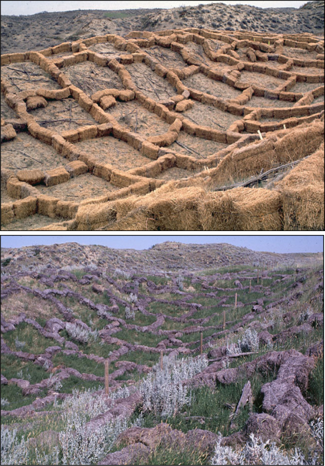
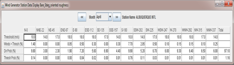
Wind erosion not only affects agricultural productivity but also soil, air, and water quality. Dust and specifically particulate matter ≤10 μm (PM-10) has adverse effects on respiratory health and also reduces visibility along roadways, resulting in auto accidents. The Wind Erosion Prediction System (WEPS) was developed by the USDA-Agricultural Research Service to simulate wind erosion and provide for conservation planning on cultivated agricultural lands. A companion product, known as the Single-Event Wind Erosion Evaluation Program (SWEEP), has also been developed which consists of the stand-alone WEPS erosion submodel combined with a graphical interface to simulate soil loss from single (i.e., daily) wind storm events. In addition to agricultural lands, wind driven dust emissions also occur from other anthropogenic sources such as construction sites, mined and reclaimed areas, landfills, and other disturbed lands. Although developed for agricultural fields, WEPS and SWEEP are useful tools for simulating erosion by wind for non-agricultural lands where typical agricultural practices are not employed. On disturbed lands, WEPS can be applied for simulating long-term (i.e., multi-year) erosion control strategies. SWEEP on the other hand was developed specifically for disturbed lands and can simulate potential soil loss for site- and date-specific planned surface conditions and control practices. This paper presents novel applications of WEPS and SWEEP for developing erosion control strategies on non-agricultural disturbed lands. Erosion control planning with WEPS and SWEEP using water and other dust suppressants, wind barriers, straw mulch, re-vegetation, and other management practices is demonstrated herein through the use of comparative simulation scenarios. The scenarios confirm the efficacy of the WEPS and SWEEP models as valuable tools for supporting the design of erosion control plans for disturbed lands that are not only cost-effective but also incorporate a science-based approach to risk assessment.
Keywords: Environmental Science.
Figures


References
-
- Armbrust D.V. Wind and sandblast injury to field crops: Effect of plant age. Agron. J. 1984;76:991–993.
-
- Buschiazzo D.E., Zobeck T.M. Validation of WEQ: RWEQ and WEPS wind erosion for different arable land management systems in the Argentinean Pampas. Earth Surf. Processes Landf. 2008;33:1839–1850.
-
- Chen L., Zhao H., Han B., Bai Z. Combined use of WEPS and Models-3/CMAQ for simulating wind erosion source emission and its environmental impact. Sci. Total Environ. 2014;466–467(2014):762–769. - PubMed
-
- Chepil W.S., Woodruff N.P. The physics of wind erosion and its control. Adv. Agron. 1963;15:211–302.
-
- Chepil W.S., Woodruff N.P., Siddoway F.H., Lyles L. Anchoring vegetative mulches. Agric. Eng. 1960;41(11):754–755. 759.
LinkOut - more resources
Full Text Sources
Other Literature Sources
