. 2017 Jan 5:7:39979.
doi: 10.1038/srep39979.

Antarctic ice sheet discharge driven by atmosphere-ocean feedbacks at the Last Glacial Termination

Affiliations

Antarctic ice sheet discharge driven by atmosphere-ocean feedbacks at the Last Glacial Termination

C J Fogwill et al. Sci Rep. .

Abstract

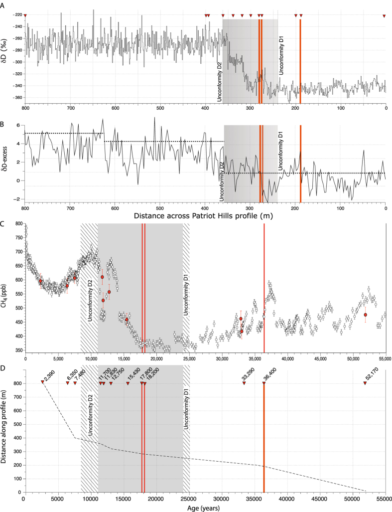
Reconstructing the dynamic response of the Antarctic ice sheets to warming during the Last Glacial Termination (LGT; 18,000-11,650 yrs ago) allows us to disentangle ice-climate feedbacks that are key to improving future projections. Whilst the sequence of events during this period is reasonably well-known, relatively poor chronological control has precluded precise alignment of ice, atmospheric and marine records, making it difficult to assess relationships between Antarctic ice-sheet (AIS) dynamics, climate change and sea level. Here we present results from a highly-resolved 'horizontal ice core' from the Weddell Sea Embayment, which records millennial-scale AIS dynamics across this extensive region. Counterintuitively, we find AIS mass-loss across the full duration of the Antarctic Cold Reversal (ACR; 14,600-12,700 yrs ago), with stabilisation during the subsequent millennia of atmospheric warming. Earth-system and ice-sheet modelling suggests these contrasting trends were likely Antarctic-wide, sustained by feedbacks amplified by the delivery of Circumpolar Deep Water onto the continental shelf. Given the anti-phase relationship between inter-hemispheric climate trends across the LGT our findings demonstrate that Southern Ocean-AIS feedbacks were controlled by global atmospheric teleconnections. With increasing stratification of the Southern Ocean and intensification of mid-latitude westerly winds today, such teleconnections could amplify AIS mass loss and accelerate global sea-level rise.


Figures

Figure 1
Figure 1
(A) Location map of Weddell Sea Embayment (WSE) and the major ice streams, with the location of Patriot Hills in the Ellsworth Mountains. Lower left. Inset map of Antarctica, with locations of the Patriot Hills (PH), WAIS Divide (WDC), Byrd, James Ross Island (JRI) and EPICA Dome C (EDC) ice cores, and the East Antarctic Ice Sheet (EAIS) and West Antarctic Ice Sheet (WAIS). (B) (i). Moderate Resolution Imaging Spectroradiometer (MODIS) mosaic showing inferred ice flow path from the head of Horseshoe Valley to Patriot Hills, where discontinuities D1 and D2 formed as a result of Blue Ice Area wind scour in front of Liberty and Marble Hills respectively, (ii) schematic stratigraphic succession, indicating ice accumulation punctuated by two periods of erosion (D1 and D2; red lines). The uppermost panel of ii represents the observed stratigraphic sequence at the Patriot Hills BIA as seen in (iii), the full GPR stratigraphic sequence at Patriot Hills BIA, where red lines indicate erosional events D1 and D2. Adapted from Winter et al..
Figure 2
Figure 2
(A) Full δD isotopic profile from the Patriot Hills BIA with chronological age ties (red triangles) highlighted. The red bars highlight the location of volcanic horizons at 17.8 ka, 18.2 ka and 36.4 ka, as recorded in other Antarctic ice core records (Supplementary Information). The grey bars highlight the area of the profile between the unconformities at 247 m (D1) and 360 m (D2) between which the GPR survey demonstrates clear dipping reflectors or isochrons across the profile (see Fig. 1B). (B) δD-excess across profile; dashed horizontal lines denote potential regime shifts across the profile at 99% confidence. (C) CH4 concentrations from ice extracted from the Patriot Hills profile (filled red circles) plotted against EPICA Dome C (EDC) (open white circles), with the approximate timings of the unconformities outlined by the hatched areas and 1σ uncertainty. (D) Age-depth model based upon chronological control ties between ~2.5 ka (2,540 years) and ~52 ka (52,170 years) from volcanic ‘tephra’ horizons and most-likely age as derived from multiple trace gas comparison to published records (CH4, CO2, N2O; see Methods and Supplementary Information). Note: the timing of the onset of ice accumulation after D2 in Patriot Hills is a conservative estimate and with future trace gas dating may be younger than that presented here.
Figure 3
Figure 3. Inter-comparison of deglacial elevation changes from Patriot Hills BIA with modelled and empirical records.
(A) δ18O from NGRIP (GICC05 chronology). (B) Cariaco Basin grey scale, a measure of latitudinal changes in the trade winds associated with the ITCZ. (C) Southern Ocean opal flux. (D) Iceberg-rafted debris flux (IRD; 100-year average) relative to Holocene average from the Scotia Sea. (E) Modelled sector-wide AIS mass loss. (F) Byrd δ18O (blue) (synchronised to GISP2 chronology) isotopic record and WAIS Divide Core δ18O (WD2014 chronology) (black) correlated with the volcanic horizons at 18 ka and 18.2 ka. (G) δD isotope profile (black dashed line), with 2-point moving average (green solid line). The red arrow highlights the apparent ∼600 m ice-sheet surface elevation change across the WSE estimated from the δD isotopic changes recorded during the ACR from the Patriot Hills BIA. Vertical boxes identify the periods defined by the Antarctic Cold Reversal (ACR) (blue) and the Younger Dryas chronozone (YD) (green). The black triangles represent the age tie points (derived from geochemically identified volcanic horizons and trace gases) in this section of the Patriot Hills BIA.
Figure 4
Figure 4
LOVECLIM transient model simulations of Southern Ocean fresh water forcing showing temperature anomalies (°C) for the ACR (14 ka minus 15 ka; left-hand panels), and subsequent surface warming during the Younger Dryas chronozone (12 ka minus 14 ka right-hand panels), with sea surface temperatures and 0.1 m sea ice contour (A,B), ocean temperature anomalies at depth (C,D, averaged over 484–694 m), and ocean temperature anomalies across the Weddell Sea (60°W to 15°W) (E,F) (constructed using ferret http://ferret.pmel.noaa.gov/Ferret/).

References

    1. Masson-Delmotte V. et al.. In Climate Change 2013: The Physical Science Basis. Contribution of Working Group I to the Fifth Assessment Report of the Intergovernmental Panel on Climate Change (eds Stocker T.F. et al..) Ch. 5, 383–464 (Cambridge University Press, 2013).
    1. Weber M. E. et al.. Millennial-scale variability in Antarctic ice-sheet discharge during the last deglaciation. Nature 510, 134–138, doi: 10.1038/nature13397 (2014). - DOI - PubMed
    1. Church J. A. et al.. In Climate Change 2013: The Physical Science Basis. Contribution of Working Group I to the Fifth Assessment Report of the Intergovernmental Panel on Climate Change (eds Stocker T.F. et al..) Ch. 13, 1137–1216 (Cambridge University Press, 2013).
    1. Collins M. et al.. In Climate Change 2013: The Physical Science Basis. Contribution of Working Group I to the Fifth Assessment Report of the Intergovernmental Panel on Climate Change (eds Stocker T.F. et al..) Ch. 12, 1029–1136 (Cambridge University Press, 2013).
    1. Joughin I., Smith B. E. & Medley B. Marine ice sheet collapse potentially under way for the Thwaites Glacier Basin, West Antarctica. Science 344, 735–738 (2014). - PubMed

Publication types