

Quantifying spatial misclassification in exposure to noise complaints among low-income housing residents across New York City neighborhoods: a Global Positioning System (GPS) study
- PMID: 28063754
- PMCID: PMC5272798
- DOI: 10.1016/j.annepidem.2016.09.017
Quantifying spatial misclassification in exposure to noise complaints among low-income housing residents across New York City neighborhoods: a Global Positioning System (GPS) study
Abstract
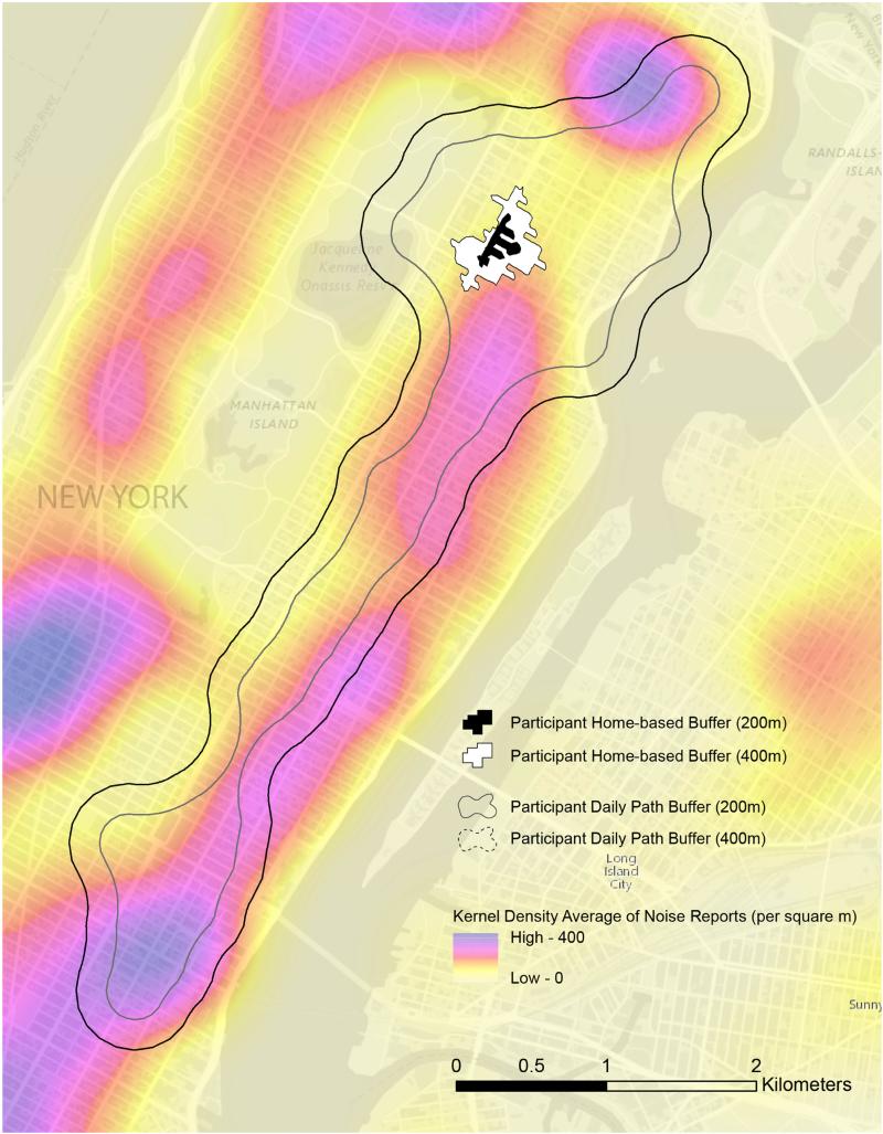
Purpose: To examine if there was spatial misclassification in exposure to neighborhood noise complaints among a sample of low-income housing residents in New York City, comparing home-based spatial buffers and Global Positioning System (GPS) daily path buffers.
Methods: Data came from the community-based NYC Low-Income Housing, Neighborhoods and Health Study, where GPS tracking of the sample was conducted for a week (analytic n = 102). We created a GPS daily path buffer (a buffering zone drawn around GPS tracks) of 200 m and 400 m. We also used home-based buffers of 200 m and 400 m. Using these "neighborhoods" (or exposure areas), we calculated neighborhood exposure to noisy events from 311 complaints data (analytic n = 143,967). Friedman tests (to compare overall differences in neighborhood definitions) were applied.
Results: There were differences in neighborhood noise complaints according to the selected neighborhood definitions (P < .05). For example, the mean neighborhood noise complaint count was 1196 per square kilometer for the 400-m home-based and 812 per square kilometer for the 400-m activity space buffer, illustrating how neighborhood definition influences the estimates of exposure to neighborhood noise complaints.
Conclusions: These analyses suggest that, whenever appropriate, GPS neighborhood definitions can be used in spatial epidemiology research in spatially mobile populations to understand people's lived experience.
Keywords: Geographic information systems; Global positioning systems; Low-income housing residents; Neighborhoods; Noise complaint exposure; Spatial epidemiology; Spatial misclassification.
Copyright © 2016 Elsevier Inc. All rights reserved.
Figures
Similar articles
-
Assessments of residential and global positioning system activity space for food environments, body mass index and blood pressure among low-income housing residents in New York City.Geospat Health. 2018 Nov 9;13(2):10.4081/gh.2018.712. doi: 10.4081/gh.2018.712. Geospat Health. 2018. PMID: 30451471 Free PMC article.
-
Residential and GPS-Defined Activity Space Neighborhood Noise Complaints, Body Mass Index and Blood Pressure Among Low-Income Housing Residents in New York City.J Community Health. 2017 Oct;42(5):974-982. doi: 10.1007/s10900-017-0344-5. J Community Health. 2017. PMID: 28386706 Free PMC article.
-
Perceived spatial stigma, body mass index and blood pressure: a global positioning system study among low-income housing residents in New York City.Geospat Health. 2016 May 31;11(2):399. doi: 10.4081/gh.2016.399. Geospat Health. 2016. PMID: 27245795
-
Mobile Sensing in Environmental Health and Neighborhood Research.Annu Rev Public Health. 2018 Apr 1;39:367-384. doi: 10.1146/annurev-publhealth-040617-013731. Annu Rev Public Health. 2018. PMID: 29608869 Review.
-
Beyond the residential neighborhood: A scoping review of research on urban neighborhood networks.Soc Sci Med. 2025 May;372:117945. doi: 10.1016/j.socscimed.2025.117945. Epub 2025 Mar 13. Soc Sci Med. 2025. PMID: 40101666
Cited by
-
Assessments of residential and global positioning system activity space for food environments, body mass index and blood pressure among low-income housing residents in New York City.Geospat Health. 2018 Nov 9;13(2):10.4081/gh.2018.712. doi: 10.4081/gh.2018.712. Geospat Health. 2018. PMID: 30451471 Free PMC article.
-
Collecting Mobility Data with GPS Methods to Understand the HIV Environmental Riskscape Among Young Black Men Who Have Sex with Men: A Multi-city Feasibility Study in the Deep South.AIDS Behav. 2018 Sep;22(9):3057-3070. doi: 10.1007/s10461-018-2163-9. AIDS Behav. 2018. PMID: 29797163 Free PMC article.
-
Alcohol Outlet Density and Area-Level Heavy Drinking Are Independent Risk Factors for Higher Alcohol-Related Complaints.J Urban Health. 2019 Dec;96(6):889-901. doi: 10.1007/s11524-018-00327-z. J Urban Health. 2019. PMID: 30511138 Free PMC article.
-
"Contextualizing Context": Reconciling Environmental Exposures, Social Networks, and Location Preferences in Health Research.Curr Environ Health Rep. 2017 Mar;4(1):51-60. doi: 10.1007/s40572-017-0121-8. Curr Environ Health Rep. 2017. PMID: 28188604 Review.
-
Social Determinants of Cardiovascular Disease.Circ Res. 2022 Mar 4;130(5):782-799. doi: 10.1161/CIRCRESAHA.121.319811. Epub 2022 Mar 3. Circ Res. 2022. PMID: 35239404 Free PMC article. Review.
References
-
- Leal C, Chaix B. The influence of geographic life environments on cardiometabolic risk factors: a systematic review, a methodological assessment and a research agenda. Obesity Reviews. 2011;12(3):217–230. - PubMed
-
- Matthews SA. Spatial polygamy and the heterogeneity of place: studying people and place via egocentric methods. Communities, neighborhoods, and health. Springer. 2011:35–55.
-
- Dragowski EA, et al. Social and sexual contexts explain sexual risk taking in young gay, bisexual, and other young men who have sex with men, ages 13–29 years. Journal of HIV/AIDS & Social Services. 2013;12(2):236–255.
Publication types
MeSH terms
Grants and funding
LinkOut - more resources
Full Text Sources
Other Literature Sources
Medical
