

Validation of a Google Street View-Based Neighborhood Disorder Observational Scale
- PMID: 28236183
- PMCID: PMC5391333
- DOI: 10.1007/s11524-017-0134-5
Validation of a Google Street View-Based Neighborhood Disorder Observational Scale
Abstract
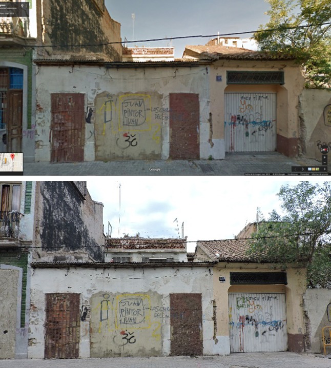
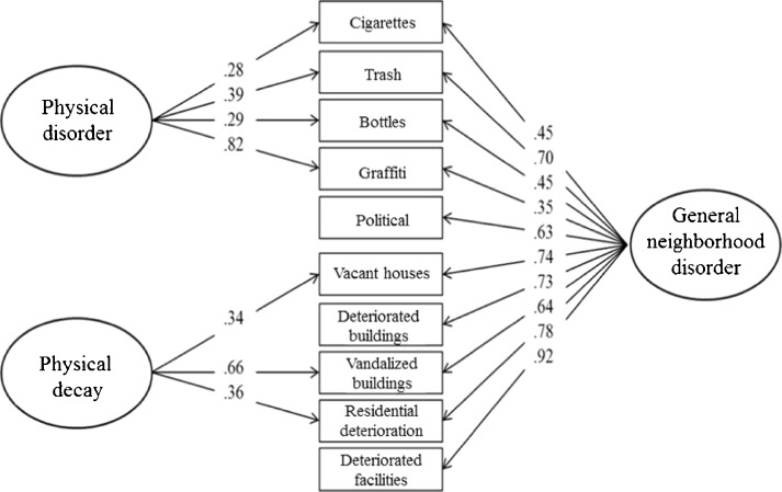
Recently, there has been a growing interest in developing new tools to measure neighborhood features using the benefits of emerging technologies. This study aimed to assess the psychometric properties of a neighborhood disorder observational scale using Google Street View (GSV). Two groups of raters conducted virtual audits of neighborhood disorder on all census block groups (N = 92) in a district of the city of Valencia (Spain). Four different analyses were conducted to validate the instrument. First, inter-rater reliability was assessed through intraclass correlation coefficients, indicating moderated levels of agreement among raters. Second, confirmatory factor analyses were performed to test the latent structure of the scale. A bifactor solution was proposed, comprising a general factor (general neighborhood disorder) and two specific factors (physical disorder and physical decay). Third, the virtual audit scores were assessed with the physical audit scores, showing a positive relationship between both audit methods. In addition, correlations between the factor scores and socioeconomic and criminality indicators were assessed. Finally, we analyzed the spatial autocorrelation of the scale factors, and two fully Bayesian spatial regression models were run to study the influence of these factors on drug-related police interventions and interventions with young offenders. All these indicators showed an association with the general neighborhood disorder. Taking together, results suggest that the GSV-based neighborhood disorder scale is a reliable, concise, and valid instrument to assess neighborhood disorder using new technologies.
Keywords: Google Street View; Neighborhood disorder; Physical decay; Physical disorder; Virtual audits.
Figures
Similar articles
-
Spatial predictive properties of built environment characteristics assessed by drop-and-spin virtual neighborhood auditing.Int J Health Geogr. 2020 May 29;19(1):21. doi: 10.1186/s12942-020-00213-5. Int J Health Geogr. 2020. PMID: 32471502 Free PMC article.
-
Validity of an ecometric neighborhood physical disorder measure constructed by virtual street audit.Am J Epidemiol. 2014 Sep 15;180(6):626-35. doi: 10.1093/aje/kwu180. Epub 2014 Aug 13. Am J Epidemiol. 2014. PMID: 25122584 Free PMC article.
-
Street Audits to Measure Neighborhood Disorder: Virtual or In-Person?Am J Epidemiol. 2017 Aug 1;186(3):265-273. doi: 10.1093/aje/kwx004. Am J Epidemiol. 2017. PMID: 28899028 Free PMC article.
-
Emerging technologies to measure neighborhood conditions in public health: implications for interventions and next steps.Int J Health Geogr. 2016 Jun 23;15(1):20. doi: 10.1186/s12942-016-0050-z. Int J Health Geogr. 2016. PMID: 27339260 Free PMC article. Review.
-
Systematic review of the use of Google Street View in health research: Major themes, strengths, weaknesses and possibilities for future research.Health Place. 2018 Jul;52:240-246. doi: 10.1016/j.healthplace.2018.07.001. Epub 2018 Jul 14. Health Place. 2018. PMID: 30015181
Cited by
-
Lessons Learned from a Citywide Abandoned Housing Experiment.J Am Plann Assoc. 2024;90(1):159-172. doi: 10.1080/01944363.2022.2128855. Epub 2023 Feb 3. J Am Plann Assoc. 2024. PMID: 38405027 Free PMC article.
-
Measuring Neighborhood Order and Disorder: a Rapid Literature Review.Curr Environ Health Rep. 2019 Dec;6(4):316-326. doi: 10.1007/s40572-019-00259-z. Curr Environ Health Rep. 2019. PMID: 31773497 Free PMC article. Review.
-
Mapping child maltreatment risk: a 12-year spatio-temporal analysis of neighborhood influences.Int J Health Geogr. 2017 Oct 18;16(1):38. doi: 10.1186/s12942-017-0111-y. Int J Health Geogr. 2017. PMID: 29047364 Free PMC article.
-
What calls for service tell us about suicide: A 7-year spatio-temporal analysis of neighborhood correlates of suicide-related calls.Sci Rep. 2018 Apr 30;8(1):6746. doi: 10.1038/s41598-018-25268-0. Sci Rep. 2018. PMID: 29712990 Free PMC article.
-
Inter-observer reliability in transect-based observations of environmental waste in greater accra and kisumu: implications for waste management.Int J Environ Sci Technol (Tehran). 2024;21(15):9409-9424. doi: 10.1007/s13762-024-05625-5. Epub 2024 Apr 22. Int J Environ Sci Technol (Tehran). 2024. PMID: 39421609 Free PMC article.
References
MeSH terms
LinkOut - more resources
Full Text Sources
Other Literature Sources
