

Utilizing patient geographic information system data to plan telemedicine service locations
- PMID: 28339932
- PMCID: PMC7651967
- DOI: 10.1093/jamia/ocx011
Utilizing patient geographic information system data to plan telemedicine service locations
Abstract
Objective: To understand potential utilization of clinical services at a rural integrated health care system by generating optimal groups of telemedicine locations from electronic health record (EHR) data using geographic information systems (GISs).
Methods: This retrospective study extracted nonidentifiable grouped data of patients over a 2-year period from the EHR, including geomasked locations. Spatially optimal groupings were created using available telemedicine sites by calculating patients' average travel distance (ATD) to the closest clinic site.
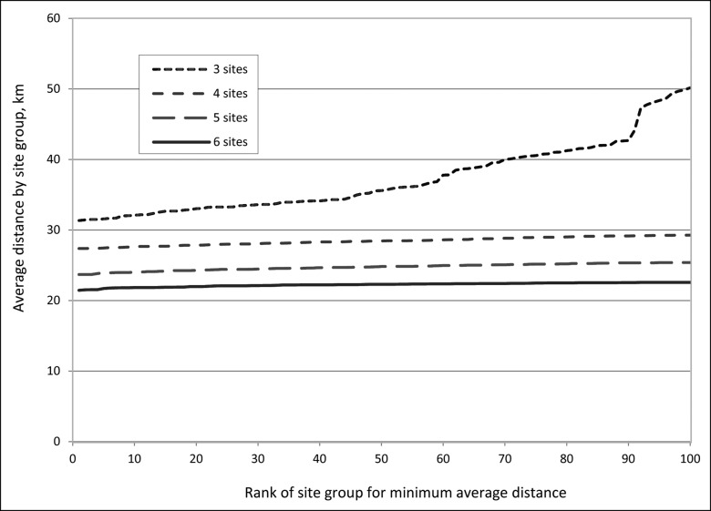
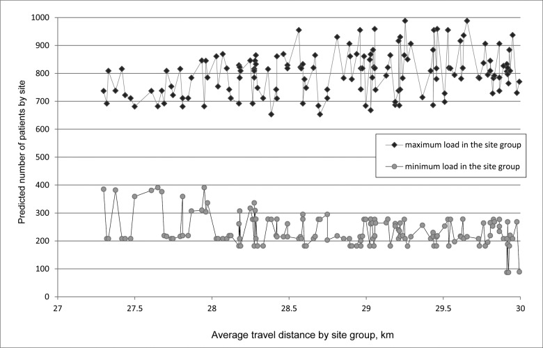
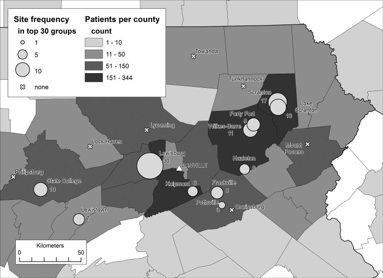
Results: A total of 4027 visits by 2049 unique patients were analyzed. The best travel distances for site groupings of 3, 4, 5, or 6 site locations were ranked based on increasing ATD. Each one-site increase in the number of available telemedicine sites decreased minimum ATD by about 8%. For a given group size, the best groupings were very similar in minimum travel distance. There were significant differences in predicted patient load imbalance between otherwise similar groupings. A majority of the best site groupings used the same small number of sites, and urban sites were heavily used.
Discussion: With EHR geospatial data at an individual patient level, we can model potential telemedicine sites for specialty access in a rural geographic area. Relatively few sites could serve most of the population. Direct access to patient GIS data from an EHR provides direct knowledge of the client base compared to methods that allocate aggregated data.
Conclusion: Geospatial data and methods can assist health care location planning, generating data about load, load balance, and spatial accessibility.
Keywords: electronic health records; geographic information systems; service planning; telemedicine.
© The Author 2017. Published by Oxford University Press on behalf of the American Medical Informatics Association. All rights reserved. For Permissions, please email: journals.permissions@oup.com
Figures
Similar articles
-
Geospatial Information System Analysis of Healthcare Need and Telemedicine Delivery in California.Telemed J E Health. 2017 May;23(5):430-434. doi: 10.1089/tmj.2016.0144. Epub 2016 Nov 11. Telemed J E Health. 2017. PMID: 27835073
-
Geomapping telehealth access to developmental-behavioral pediatrics.Telemed J E Health. 2013 Aug;19(8):585-90. doi: 10.1089/tmj.2012.0226. Epub 2013 Jun 11. Telemed J E Health. 2013. PMID: 23756240
-
Geographic Information Systems Mapping of Diabetic Retinopathy in an Ocular Telemedicine Network.JAMA Ophthalmol. 2017 Jul 1;135(7):715-721. doi: 10.1001/jamaophthalmol.2017.1153. JAMA Ophthalmol. 2017. PMID: 28520876 Free PMC article.
-
Healthcare stakeholders' perceptions and experiences of factors affecting the implementation of critical care telemedicine (CCT): qualitative evidence synthesis.Cochrane Database Syst Rev. 2021 Feb 18;2(2):CD012876. doi: 10.1002/14651858.CD012876.pub2. Cochrane Database Syst Rev. 2021. PMID: 33599282 Free PMC article.
-
GIS and health care.Annu Rev Public Health. 2003;24:25-42. doi: 10.1146/annurev.publhealth.24.012902.141012. Epub 2002 Oct 23. Annu Rev Public Health. 2003. PMID: 12668754 Review.
Cited by
-
Examining How Social Risk Factors Are Integrated Into Clinical Settings Using Existing Data: A Scoping Review.Ann Fam Med. 2023 Feb;21(Suppl 2):S68-S74. doi: 10.1370/afm.2932. Ann Fam Med. 2023. PMID: 36849484 Free PMC article.
-
Examining rehabilitation access disparities: an integrated analysis of electronic health record data and population characteristics through bivariate choropleth mapping.BMC Health Serv Res. 2024 Feb 7;24(1):170. doi: 10.1186/s12913-024-10649-1. BMC Health Serv Res. 2024. PMID: 38321457 Free PMC article.
-
Diagnostic precision and identification of rare diseases is dependent on distance of residence relative to tertiary medical facilities.Orphanet J Rare Dis. 2021 Mar 22;16(1):131. doi: 10.1186/s13023-021-01769-6. Orphanet J Rare Dis. 2021. PMID: 33745447 Free PMC article.
-
Progress towards using community context with clinical data in primary care.Fam Med Community Health. 2018 Dec 6;7(1):e000028. doi: 10.1136/fmch-2018-000028. eCollection 2019. Fam Med Community Health. 2018. PMID: 32148692 Free PMC article.
-
An interactive geographic information system to inform optimal locations for healthcare services.PLOS Digit Health. 2023 May 8;2(5):e0000253. doi: 10.1371/journal.pdig.0000253. eCollection 2023 May. PLOS Digit Health. 2023. PMID: 37155602 Free PMC article.
References
-
- Health Information Technology for Economic and Clinical Health (HITECH) Act, Title XIII of Division A and Title IV of Division B of the American Recovery and Reinvestment Act of 2009 (ARRA), Pub. L. No. 111-5, 123 Stat. 226 (February 17, 2009).
-
- Environmental Systems Research Institute What is GIS? http://www.esri.com/what-is-gis/. Accessed January 7, 2015.
-
- McLafferty SL. GIS and Health Care Annu Rev Public Health. 2003; 24:25–42 - PubMed
MeSH terms
LinkOut - more resources
Full Text Sources
Other Literature Sources
Medical
Research Materials
