

Land altitude, slope, and coverage as risk factors for Porcine Reproductive and Respiratory Syndrome (PRRS) outbreaks in the United States
- PMID: 28414720
- PMCID: PMC5393554
- DOI: 10.1371/journal.pone.0172638
Land altitude, slope, and coverage as risk factors for Porcine Reproductive and Respiratory Syndrome (PRRS) outbreaks in the United States
Abstract
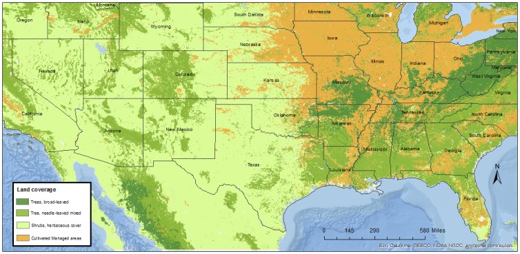
Porcine reproductive and respiratory syndrome (PRRS) is, arguably, the most impactful disease on the North American swine industry. The Swine Health Monitoring Project (SHMP) is a national volunteer initiative aimed at monitoring incidence and, ultimately, supporting swine disease control, including PRRS. Data collected through the SHMP currently represents approximately 42% of the sow population of the United States. The objective of the study here was to investigate the association between geographical factors (including land elevation, and land coverage) and PRRS incidence as recorded in the SHMP. Weekly PRRS status data from sites participating in the SHMP from 2009 to 2016 (n = 706) was assessed. Number of PRRS outbreaks, years of participation in the SHMP, and site location were collected from the SHMP database. Environmental features hypothesized to influence PRRS risk included land coverage (cultivated areas, shrubs and trees), land altitude (in meters above sea level) and land slope (in degrees compared to surrounding areas). Other risk factors considered included region, production system to which the site belonged, herd size, and swine density in the area in which the site was located. Land-related variables and pig density were captured in raster format from a number of sources and extracted to points (farm locations). A mixed-effects Poisson regression model was built; and dependence among sites that belonged to a given production system was accounted for using a random effect at the system level. The annual mean and median number of outbreaks per farm was 1.38 (SD: 1.6), and 1 (IQR: 2.0), respectively. The maximum annual number of outbreaks per farm was 9, and approximately 40% of the farms did not report any outbreak. Results from the final multivariable model suggested that increments of swine density and herd size increased the risk for PRRS outbreaks (P < 0.01). Even though altitude (meters above sea level) was not significant in the final model, farms located in terrains with a slope of 9% or higher had lower rates of PRRS outbreaks compared to farms located in terrains with slopes lower than 2% (P < 0.01). Finally, being located in an area of shrubs/ herbaceous cover and trees lowered the incidence rate of PRRS outbreaks compared to being located in cultivated/ managed areas (P < 0.05). In conclusion, highly inclined terrains were associated with fewer PRRS outbreaks in US sow farms, as was the presence of shrubs and trees when compared to cultivated/ managed areas. Influence of terrain characteristics on spread of airborne diseases, such as PRRS, may help to predicting disease risk, and effective planning of measures intended to mitigate and prevent risk of infection.
Conflict of interest statement
Figures


References
-
- Holtkamp DJ, Kliebenstein JB, Neumann EJ, Zimmerman JJ, Rotto HF, Yoder TK, et al. Assessment of the economic impact of porcine reproductive and respiratory syndrome virus on United States pork producers. J. Swine Health Prod. 2013;21(2):72–84.
-
- Betlach C, Baldry H, Homann T, VanderWaal K, Kanankege K, Morrison B. Swine Health Monitoring Project serving as swine disease surveillance system. National Hog Farmer. 2016, http://nationalhogfarmer.com/health/swine-health-monitoring-project-serv.... Last accessed Oct 04, 2016.
MeSH terms
LinkOut - more resources
Full Text Sources
Other Literature Sources
