

Landscape and environmental influences on Mycobacterium ulcerans distribution among aquatic sites in Ghana
- PMID: 28437439
- PMCID: PMC5402941
- DOI: 10.1371/journal.pone.0176375
Landscape and environmental influences on Mycobacterium ulcerans distribution among aquatic sites in Ghana
Abstract
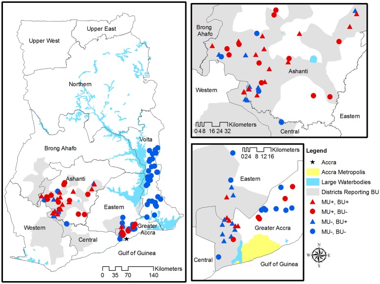
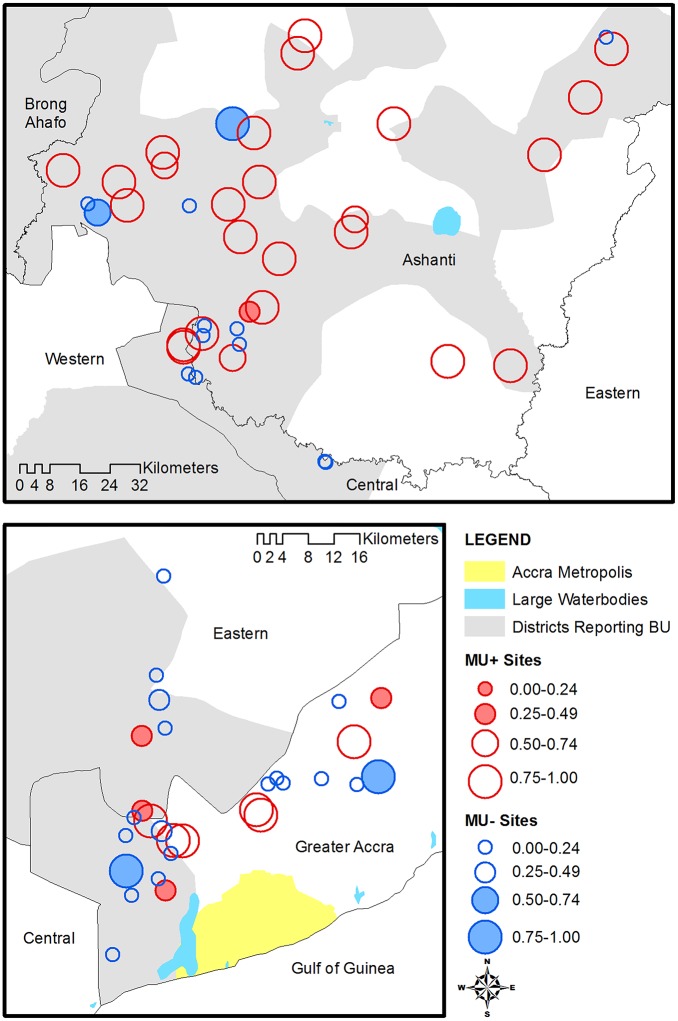
Buruli ulcer, caused by Mycobacterium ulcerans, is highly endemic in West Africa. While the mode of transmission is unknown, many studies associate Buruli ulcer with different types of water exposure. We present results from the largest study to date to test for M. ulcerans in aquatic sites and identify environmental attributes associated with its presence. Environmental samples from 98 aquatic sites in the Greater Accra, Ashanti, and Volta regions of Ghana were tested for the presence of M. ulcerans DNA by polymerase chain reaction. The proportion of aquatic sites positive for M. ulcerans varied by region: Ashanti 66% (N = 39), Greater Accra 34% (N = 29), and Volta 0% (N = 30). We explored the spatial distribution of M. ulcerans positive and negative water bodies and found no significant clusters. We also determined both highly localized water attributes and broad scale remotely sensed land cover and terrain environmental characteristics associated with M. ulcerans presence through logistic regression. Our results concur with published results regarding conditions suitable for M. ulcerans growth and associations with Buruli ulcer disease burden with regards to water characteristics and disturbed environments, but differ from others with regards to spatial associations and topographic effects such as elevation and wetness. While our results suggest M. ulcerans is an environmental organism existing in a specific ecological niche, they also reveal variation in the elements defining this niche across the sites considered. In addition, despite the causal association between Buruli ulcer and M. ulcerans, we observed no significant statistical association between case reports of Buruli ulcer and presence of M. ulcerans in nearby waterbodies.
Conflict of interest statement
Figures
Similar articles
-
Distribution of Mycobacterium ulcerans in buruli ulcer endemic and non-endemic aquatic sites in Ghana.PLoS Negl Trop Dis. 2008 Mar 26;2(3):e205. doi: 10.1371/journal.pntd.0000205. PLoS Negl Trop Dis. 2008. PMID: 18365034 Free PMC article.
-
Associations between Mycobacterium ulcerans and aquatic plant communities of West Africa: implications for Buruli ulcer disease.Ecohealth. 2014 Jun;11(2):184-96. doi: 10.1007/s10393-013-0898-3. Epub 2014 Jan 18. Ecohealth. 2014. PMID: 24442959
-
Modelling the spatial distribution of aquatic insects (Order Hemiptera) potentially involved in the transmission of Mycobacterium ulcerans in Africa.Parasit Vectors. 2018 Sep 6;11(1):501. doi: 10.1186/s13071-018-3066-3. Parasit Vectors. 2018. PMID: 30189883 Free PMC article.
-
In the case of transmission of Mycobacterium ulcerans in buruli ulcer disease Acanthamoeba species stand accused.Ghana Med J. 2011 Mar;45(1):31-4. doi: 10.4314/gmj.v45i1.68920. Ghana Med J. 2011. PMID: 21572823 Free PMC article. Review.
-
Buruli ulcer (Mycobacterium ulcerans infection).Trans R Soc Trop Med Hyg. 2008 Oct;102(10):969-78. doi: 10.1016/j.trstmh.2008.06.006. Epub 2008 Jul 26. Trans R Soc Trop Med Hyg. 2008. PMID: 18657836 Review.
Cited by
-
Understanding the transmission of Mycobacterium ulcerans: A step towards controlling Buruli ulcer.PLoS Negl Trop Dis. 2021 Aug 26;15(8):e0009678. doi: 10.1371/journal.pntd.0009678. eCollection 2021 Aug. PLoS Negl Trop Dis. 2021. PMID: 34437549 Free PMC article. Review.
-
Variable Number Tandem Repeat Profiling of Mycobacterium ulcerans Reveals New Genotypes in Buruli Ulcer Endemic Communities in Ghana and Côte d'Ivoire.Front Microbiol. 2022 Jun 23;13:872579. doi: 10.3389/fmicb.2022.872579. eCollection 2022. Front Microbiol. 2022. PMID: 35814673 Free PMC article.
-
Recovery of Mycobacteria from Heavily Contaminated Environmental Matrices.Microorganisms. 2021 Oct 19;9(10):2178. doi: 10.3390/microorganisms9102178. Microorganisms. 2021. PMID: 34683499 Free PMC article.
-
A combined field study of Buruli ulcer disease in southeast Benin proposing preventive strategies based on epidemiological, geographic, behavioural and environmental analyses.PLOS Glob Public Health. 2022 Jan 7;2(1):e0000095. doi: 10.1371/journal.pgph.0000095. eCollection 2022. PLOS Glob Public Health. 2022. PMID: 36962132 Free PMC article.
-
From hidden outbreaks to epidemic emergencies: the threat associated with neglecting emerging pathogens.Microbes Infect. 2019 Jan-Feb;21(1):4-9. doi: 10.1016/j.micinf.2018.06.004. Epub 2018 Jun 27. Microbes Infect. 2019. PMID: 29959095 Free PMC article. Review.
References
-
- Buruli ulcer: Mycobacterium ulcerans infection. World Health Organization, 2000.
-
- van der Werf TS, Stienstra Y, Johnson RC, Phillips R, Adjei O, Fleischer B, et al. Mycobacterium ulcerans disease. Bulletin of the World Health Organization. 2005;83(10):785–91. doi: /S0042-96862005001000016 - PMC - PubMed
-
- Merritt R, Benbow ME, Small P. Unraveling an emerging disease associated with disturbed aquatic environments: the case of Buruli ulcer. Front Ecol Environ. 2005;3(6):323–31.
-
- Thangaraj HS, Evans MRW, Wansbrough-Jones MH. Mycobacterium ulcerans disease; Buruli ulcer. T Roy Soc Trop Med H. 1999;93(4):337–40. - PubMed
MeSH terms
LinkOut - more resources
Full Text Sources
Other Literature Sources
