

Deforestation and Carbon Loss in Southwest Amazonia: Impact of Brazil's Revised Forest Code
- PMID: 28510059
- PMCID: PMC5544789
- DOI: 10.1007/s00267-017-0879-3
Deforestation and Carbon Loss in Southwest Amazonia: Impact of Brazil's Revised Forest Code
Abstract
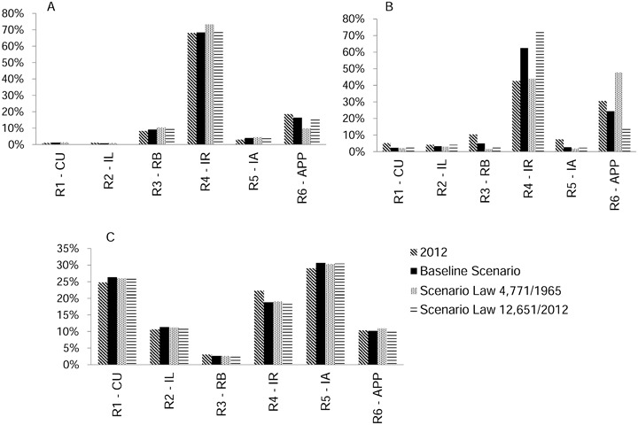
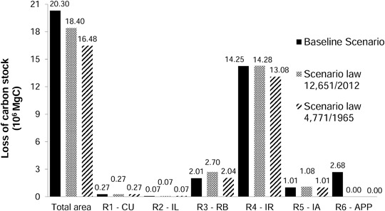
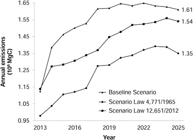
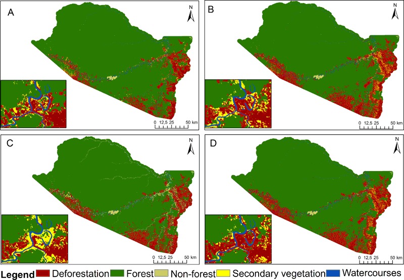
In 2012 Brazil's National Congress altered the country's Forest Code, decreasing various environmental protections in the set of regulations governing forests. This suggests consequences in increased deforestation and emissions of greenhouse gases and in decreased protection of fragile ecosystems. To ascertain the effects, a simulation was run to the year 2025 for the municipality (county) of Boca do Acre, Amazonas state, Brazil. A baseline scenario considered historical behavior (which did not respect the Forest Code), while two scenarios considered full compliance with the old Forest Code (Law 4771/1965) and the current Code (Law 12,651/2012) regarding the protection of "areas of permanent preservation" (APPs) along the edges of watercourses. The models were parameterized from satellite imagery and simulated using Dinamica-EGO software. Deforestation actors and processes in the municipality were observed in loco in 2012. Carbon emissions and loss of forest by 2025 were computed in the three simulation scenarios. There was a 10% difference in the loss of carbon stock and of forest between the scenarios with the two versions of the Forest Code. The baseline scenario showed the highest loss of carbon stocks and the highest increase in annual emissions. The greatest damage was caused by not protecting wetlands and riparian zones.
Keywords: Climate change; Forest policy; Global warming; Land-use change; Landscape dynamics; Tropical forest.
Conflict of interest statement
The authors declare that they have no competing interests.
Figures


Similar articles
-
Deforestation and Carbon Stock Loss in Brazil's Amazonian Settlements.Environ Manage. 2017 Mar;59(3):393-409. doi: 10.1007/s00267-016-0783-2. Epub 2016 Oct 24. Environ Manage. 2017. PMID: 27778066 Free PMC article.
-
Carbon stock loss from deforestation through 2013 in Brazilian Amazonia.Glob Chang Biol. 2015 Mar;21(3):1271-92. doi: 10.1111/gcb.12798. Epub 2015 Jan 8. Glob Chang Biol. 2015. PMID: 25380507
-
Simulating deforestation and carbon loss in Amazonia: impacts in Brazil's Roraima state from reconstructing Highway BR-319 (Manaus-Porto Velho).Environ Manage. 2015 Feb;55(2):259-78. doi: 10.1007/s00267-014-0408-6. Epub 2014 Dec 4. Environ Manage. 2015. PMID: 25472831
-
Carbon Fluxes and Stocks by Mexican Tropical Forested Wetland Soils: A Critical Review of Its Role for Climate Change Mitigation.Int J Environ Res Public Health. 2020 Oct 9;17(20):7372. doi: 10.3390/ijerph17207372. Int J Environ Res Public Health. 2020. PMID: 33050293 Free PMC article. Review.
-
[Regional and global estimates of carbon stocks and carbon sequestration capacity in forest ecosystems: A review].Ying Yong Sheng Tai Xue Bao. 2015 Sep;26(9):2881-90. Ying Yong Sheng Tai Xue Bao. 2015. PMID: 26785575 Review. Chinese.
Cited by
-
Wild dogs at stake: deforestation threatens the only Amazon endemic canid, the short-eared dog (Atelocynus microtis).R Soc Open Sci. 2020 Apr 22;7(4):190717. doi: 10.1098/rsos.190717. eCollection 2020 Apr. R Soc Open Sci. 2020. PMID: 32431857 Free PMC article.
-
Species distribution modeling reveals strongholds and potential reintroduction areas for the world's largest eagle.PLoS One. 2019 May 13;14(5):e0216323. doi: 10.1371/journal.pone.0216323. eCollection 2019. PLoS One. 2019. PMID: 31083656 Free PMC article.
-
Biases and limitations of Global Forest Change and author-generated land cover maps in detecting deforestation in the Amazon.PLoS One. 2022 Jul 6;17(7):e0268970. doi: 10.1371/journal.pone.0268970. eCollection 2022. PLoS One. 2022. PMID: 35793333 Free PMC article.
References
-
- Almeida CA (2009) Estimativa da área e do tempo de permanência da vegetação secundária na Amazônia Legal por meio de imagens Landsat/TM. pp. 129 (INPE-15651-TDI/1429). Master’s dissertation in remote sensing. Instituto Nacional de Pesquisas Espaciais, http://urlib.net/sid.inpe.br/mtc-m18@80/2008/11.04.18.45.
-
- Alves Sobrinho T, Oliveira PTS, Rodrigues DBB, Ayres FM. Delimitação automática de bacias hidrográficas utilizando dados SRTM. Engenharia Agrícola. 2010;30(1):46–57. doi: 10.1590/S0100-69162010000100005. - DOI
-
- Brazil (2012) Lei n° 12.651, de 25 de maio de 2012. http://www.planalto.gov.br/ccivil_03/_ato2011-2014/2012/lei/l12651.htm
-
- Brazil (2015) Intended Nationally Determined Contribution towards Achieving the Objective of the United Nations Framework Convention on Climate Change. pp. 10 http://www4.unfccc.int/submissions/INDC/Published%20Documents/Brazil/1/B...
MeSH terms
Substances
LinkOut - more resources
Full Text Sources
Other Literature Sources
