. 2017 Jul 5;12(7):e0179791.
doi: 10.1371/journal.pone.0179791. eCollection 2017.

Use of navigation channels by Lake Sturgeon: Does channelization increase vulnerability of fish to ship strikes?

Affiliations

Use of navigation channels by Lake Sturgeon: Does channelization increase vulnerability of fish to ship strikes?

Darryl W Hondorp et al. PLoS One. .

Abstract

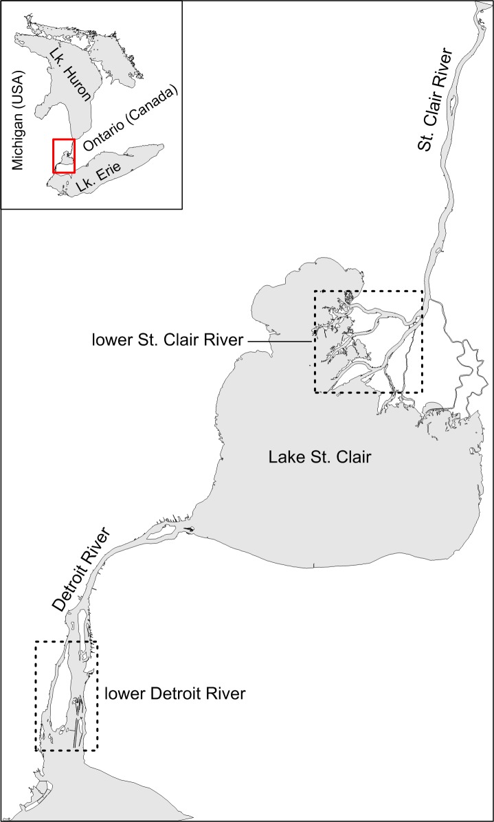
Channelization for navigation and flood control has altered the hydrology and bathymetry of many large rivers with unknown consequences for fish species that undergo riverine migrations. In this study, we investigated whether altered flow distributions and bathymetry associated with channelization attracted migrating Lake Sturgeon (Acipenser fulvescens) into commercial navigation channels, potentially increasing their exposure to ship strikes. To address this question, we quantified and compared Lake Sturgeon selection for navigation channels vs. alternative pathways in two multi-channel rivers differentially affected by channelization, but free of barriers to sturgeon movement. Acoustic telemetry was used to quantify Lake Sturgeon movements. Under the assumption that Lake Sturgeon navigate by following primary flow paths, acoustic-tagged Lake Sturgeon in the more-channelized lower Detroit River were expected to choose navigation channels over alternative pathways and to exhibit greater selection for navigation channels than conspecifics in the less-channelized lower St. Clair River. Consistent with these predictions, acoustic-tagged Lake Sturgeon in the more-channelized lower Detroit River selected the higher-flow and deeper navigation channels over alternative migration pathways, whereas in the less-channelized lower St. Clair River, individuals primarily used pathways alternative to navigation channels. Lake Sturgeon selection for navigation channels as migratory pathways also was significantly higher in the more-channelized lower Detroit River than in the less-channelized lower St. Clair River. We speculated that use of navigation channels over alternative pathways would increase the spatial overlap of commercial vessels and migrating Lake Sturgeon, potentially enhancing their vulnerability to ship strikes. Results of our study thus demonstrated an association between channelization and the path use of migrating Lake Sturgeon that could prove important for predicting sturgeon-vessel interactions in navigable rivers as well as for understanding how fish interact with their habitat in landscapes altered by human activity.


Conflict of interest statement

Competing Interests: The authors have declared that no competing interests exist.

Figures

Fig 1
Fig 1. The Detroit-St. Clair River system.
Dashed boxes delineate the extent of the lower Detroit and lower St. Clair rivers. The direction of flow is from Lake Huron to Lake Erie (i.e., from north to south).
Fig 2
Fig 2. The lower Detroit River (left panel) and lower St. Clair River (right panel).
Red circles show locations of acoustic receivers. The unfilled circle shows the location of station DRL-02 in 2012. Beginning in 2013, DRL-02 was moved to its current location (filled red circle with text “DRL-02”).
Fig 3
Fig 3
Bathymetry of the lower Detroit River east of Grosse Ile before (A, B) and after (C) channelization (circa 1900 vs. 2012). Black arrows indicate potential pathways for fish movement. Brown-shaded areas show dredge spoil disposal locations. Above-water compensating works are shown in red. Bathymetry data for the lower Detroit River in 2012 was provided by the U.S. Army Corps of Engineers-Detroit District.
Fig 4
Fig 4. Current hydraulic and bathymetric characteristics of navigation channels (shaded) and other main channels in the lower Detroit and St. Clair rivers.
Trent. = Trenton Channel, St.-Sgr. = Sugar I.-to-Stony I. channel, Liv. = Livingstone Channel, Amh. = Amherstburg Channel, Upper panel: mean annual discharge (± 95% confidence interval). Data from Table 3 of Holtschlag and Koschik [27]. Middle panel: Variation (median and quartiles) in channel depth. Error bars represent the 10th and 90th percentiles. Data provided by the U.S. Army Corps of Engineers-Detroit District. Lower panel: Variation (median and quartiles) in channel depth-averaged current velocity. Data provided by the NOAA-Great Lakes Environmental Research Laboratory. Error bars represent the 10th and 90th percentiles.
Fig 5
Fig 5. Path use (% of observed passages) by acoustic-tagged Lake Sturgeon in the lower Detroit (left panel) and St. Clair (right panel) rivers.
Total number of passages was 280 in the lower Detroit River and 404 in the lower St. Clair River. Movement pathways through navigation channels are shown in red. Lake Sturgeon moving upstream at Sugar Island in the lower Detroit River turned eastward and entered the Livingstone navigation channel (solid path) rather than continuing along the expected path (dashed extension) towards Stony Island.
Fig 6
Fig 6. Probability (mean±95% confidence interval) of navigation channel use by acoustic-tagged Lake Sturgeon by river (Detroit vs. St. Clair) and direction of movement (upstream vs. downstream).
Expected probabilities of navigation channel use under the null model are shown as dashed horizontal lines.
Fig 7
Fig 7. Probability (mean±95% confidence interval) of navigation channel use by acoustic-tagged Lake Sturgeon in the lower Detroit and St. Clair rivers when analyses included and excluded the extrapolated Livingstone Channel passage data.
Upstream and downstream passages were pooled because direction of sturgeon movement for the extrapolated sturgeon passage data was unknown. Expected probabilities of navigation channel use under the null model are shown as dashed horizontal lines.
Fig 8
Fig 8. Photographs of injured and dead Lake Sturgeon with wounds consistent with vessel propeller strikes.
Upper panel: Lake Sturgeon with fractured skull and operculum photographed in the Livingston Channel of the lower Detroit River on 13 May 2014 (photo credit: P.A. Thompson). Lower panel: Decapitated Lake Sturgeon carcass photographed in the South Channel of the lower St. Clair River on 10 June 2010 (photo credit: D.W. Hondorp).

References

    1. Brooker MP. The ecological effects of channelization. Geographical Journal. 1985;151(1):63–9.
    1. Gore JA, Shields FD. Can large rivers be restored?. BioScience. 1995;45(3):142–52. doi: 10.2307/1312553 - DOI
    1. Nielsen L, Sheehan R, Orth D. Impacts of navigation on riverine fish production in the United States. Polish Archives of Hydrobiology. 1986;33(3):277–94.
    1. Swales S. A ‘before and after’ study of the effects of land drainage works on fish stocks in the upper reaches of a lowland river. Aquaculture Research. 1982;13(3):105–14. doi: 10.1111/j.1365-2109.1982.tb00038.x - DOI
    1. Wohl E. Disconnected rivers: linking rivers to landscapes. New Haven, CT: Yale University Press; 2004.

LinkOut - more resources