. 2017 Aug 14;7(1):8082.
doi: 10.1038/s41598-017-07818-0.

Micro-epidemiology and spatial heterogeneity of P. vivax parasitaemia in riverine communities of the Peruvian Amazon: A multilevel analysis

Affiliations

Micro-epidemiology and spatial heterogeneity of P. vivax parasitaemia in riverine communities of the Peruvian Amazon: A multilevel analysis

Gabriel Carrasco-Escobar et al. Sci Rep. .

Abstract

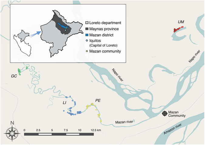
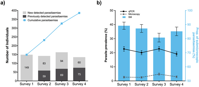
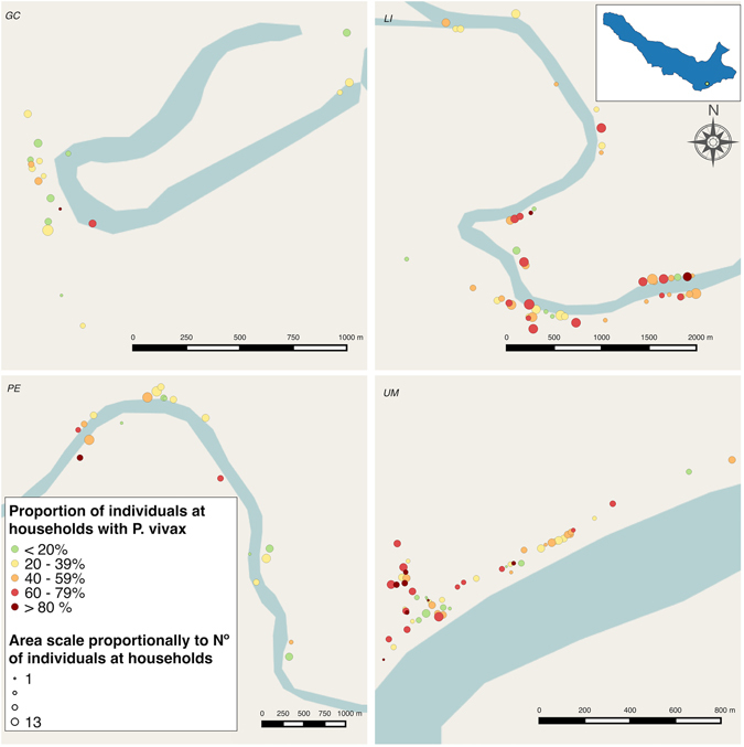
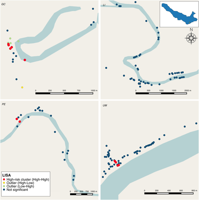
Malaria has steadily increased in the Peruvian Amazon over the last five years. This study aimed to determine the parasite prevalence and micro-geographical heterogeneity of Plasmodium vivax parasitaemia in communities of the Peruvian Amazon. Four cross-sectional active case detection surveys were conducted between May and July 2015 in four riverine communities in Mazan district. Analysis of 2785 samples of 820 individuals nested within 154 households for Plasmodium parasitaemia was carried out using light microscopy and qPCR. The spatio-temporal distribution of Plasmodium parasitaemia, dominated by P. vivax, was shown to cluster at both household and community levels. Of enrolled individuals, 47% had at least one P. vivax parasitaemia and 10% P. falciparum, by qPCR, both of which were predominantly sub-microscopic and asymptomatic. Spatial analysis detected significant clustering in three communities. Our findings showed that communities at small-to-moderate spatial scales differed in P. vivax parasite prevalence, and multilevel Poisson regression models showed that such differences were influenced by factors such as age, education, and location of households within high-risk clusters, as well as factors linked to a local micro-geographic context, such as travel and occupation. Complex transmission patterns were found to be related to human mobility among communities in the same micro-basin.


Conflict of interest statement

The authors declare that they have no competing interests.

Figures

Figure 1
Figure 1
Study area in Mazán district, Loreto Department, Peruvian Amazon. Spatial distribution of Gamitanacocha (GC, green circles), Libertad (LI, blue circles), Primero de Enero (PE, yellow circles) and Urco Miraño (UM, red circles) communities in the Mazan district. Map generated with QGIS 2.16 (QGIS Development Team, 2016. QGIS Geographic Information System. Open Source Geospatial Foundation Project. http://www.qgis.org/).
Figure 2
Figure 2
Distribution of P. vivax parasitaemia and parasite prevalence over time (4 ACD surveys): (a) Number individuals with new detected (light grey bars), previously detected (dark grey bars) and cumulative (light blue squares) P. vivax parasitaemia, and (b) P. vivax parasite prevalence by microscopy (grey dashed line), and qPCR (black solid line), and the proportion of submicroscopic parasitaemia (SM, light blue bars) in each survey round. Error bars represent the standard error of the proportion (SEP) in each survey round. Surveys were conducted from May to July 2015, with 10 days between surveys.
Figure 3
Figure 3
Proportion of participants per household with at least one P. vivax parasitaemia along the follow-up in: Gamitanacocha (GC), Libertad (LI), Primero de Enero (PE) and Urco Miraño (UM). Each point represents a household location. Map generated with QGIS 2.16 (QGIS Development Team, 2016. QGIS Geographic Information System. Open Source Geospatial Foundation Project. http://www.qgis.org/).
Figure 4
Figure 4
Local Indicators of Spatial Association (LISA) clustering analysis of P. vivax parasitaemia in: Gamitanacocha (GC), Libertad (LI), Primero de Enero (PE) and Urco Miraño (UM). Each point represents a household location. Statistically significant clusters corrected by false discovery rate were represented as follows: Households with high parasitaemia surrounded by a neighborhood with high parasitaemia (High-risk cluster − red circles), households with high parasitaemia surrounded by a neighborhood with low parasitaemia (High-low outlier − yellow circles) and households with low parasitaemia surrounded by a neighborhood with high parasitaemia (Low-high outlier − green circles). Map generated with QGIS 2.16 (QGIS Development Team, 2016. QGIS Geographic Information System. Open Source Geospatial Foundation Project. http://www.qgis.org/).

References

    1. WHO Global Malaria Programme. World Malaria Report 2014. (WHO, Geneva, 2014).
    1. Bhatt S, et al. The effect of malaria control on Plasmodium falciparum in Africa between 2000 and 2015. Nature. 2015;526:207–211. doi: 10.1038/nature15535. - DOI - PMC - PubMed
    1. Ministerio de Salud del Peru. Sala de Situación de Salud: Malaria (2015).
    1. Roper MH, et al. The epidemiology of malaria in an epidemic area of the Peruvian Amazon. Am. J. Trop. Med. Hyg. 2000;62:247–256. doi: 10.4269/ajtmh.2000.62.247. - DOI - PubMed
    1. Aramburú Guarda J, Ramal Asayag C, Witzig R. Malaria reemergence in the Peruvian Amazon region. Emerg. Infect. Dis. 1999;5:209–215. doi: 10.3201/eid0502.990204. - DOI - PMC - PubMed

Publication types

MeSH terms

LinkOut - more resources