

Spatial multi-scale relationships of ecosystem services: A case study using a geostatistical methodology
- PMID: 28842616
- PMCID: PMC5573410
- DOI: 10.1038/s41598-017-09863-1
Spatial multi-scale relationships of ecosystem services: A case study using a geostatistical methodology
Abstract
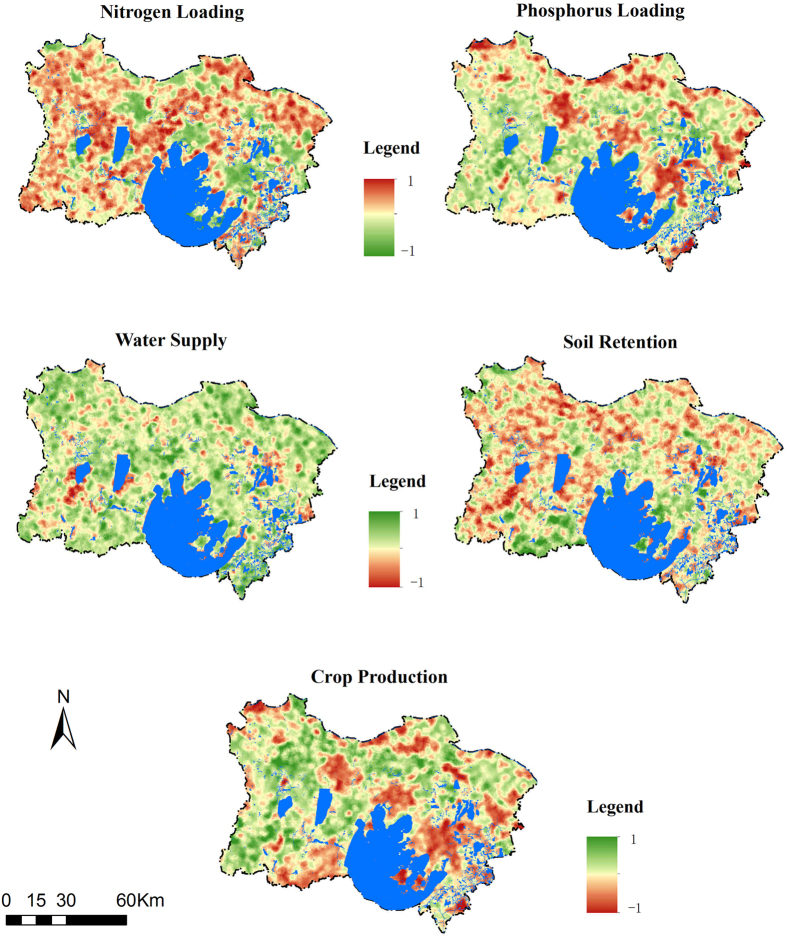
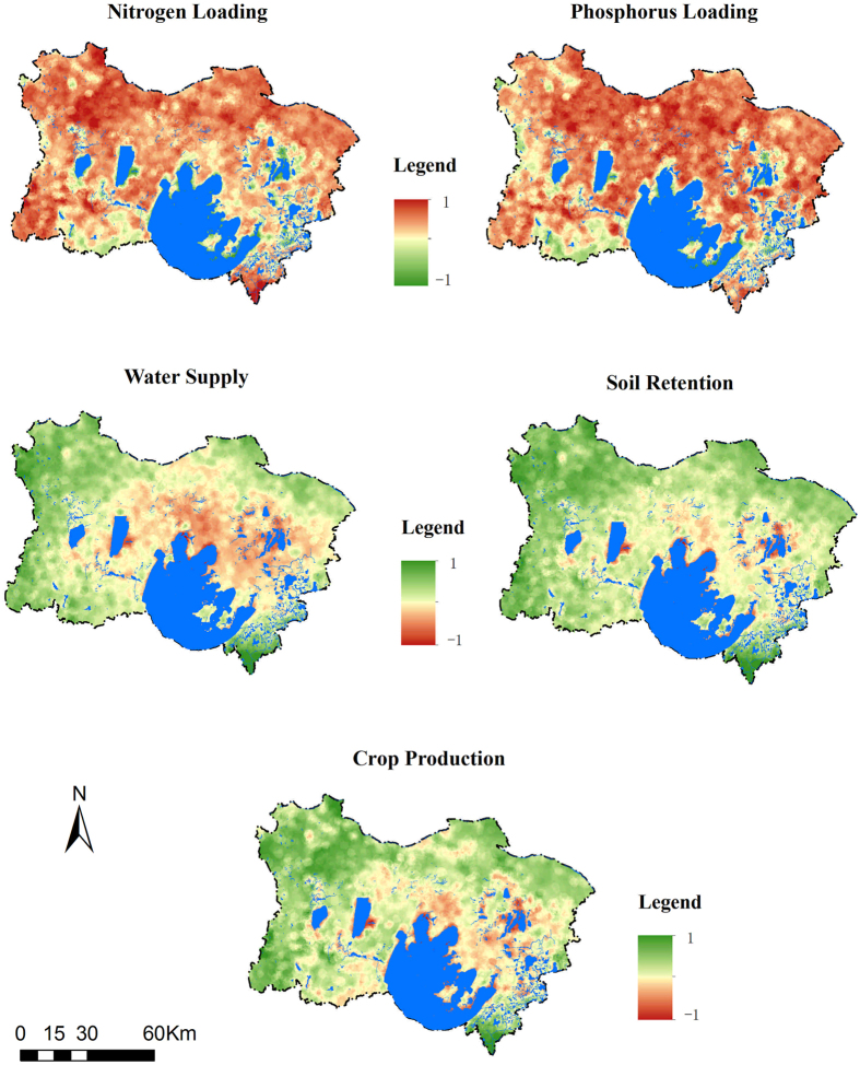
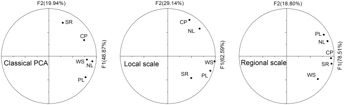
Adequately understanding the spatial multi-scale relationships of ecosystem services (ES) is an important step for environmental management decision-making. Here, we used spatially explicit methods to estimate five critical ES (nitrogen and phosphorous purifications, crop production, water supply and soil retention) related to non-point source (NPS) pollution in the Taihu Basin region of eastern China. Then a factorial kriging analysis and stepwise multiple regression were performed to identify the spatial multi-scale relationships of ES and their dominant factors at each scale. The spatial variations in ES were characterized at the 12 km and 83 km scales and the result indicated that the relationships of these services were scale dependent. It was inferred that at the 12 km scale, ES were controlled by anthropogenic activities and their relationships were dependent on socio-economic factors. At the 83 km scale, we suggested that ES were primarily dominated by the physical environment. Moreover, the policy implications of ES relationships and their dominant factors were discussed for the multi-level governance of NPS pollution. Overall, this study presents an optimized approach to identifying ES relationships at multiple spatial scales and illustrates how appropriate information can help guide water management.
Conflict of interest statement
The authors declare that they have no competing interests.
Figures

Similar articles
-
A conservation decision-making framework based on ecosystem service hotspot and interaction analyses on multiple scales.Sci Total Environ. 2018 Dec 1;643:277-291. doi: 10.1016/j.scitotenv.2018.06.103. Epub 2018 Jun 22. Sci Total Environ. 2018. PMID: 29940440
-
Factorial kriging and stepwise regression approach to identify environmental factors influencing spatial multi-scale variability of heavy metals in soils.J Hazard Mater. 2013 Oct 15;261:387-97. doi: 10.1016/j.jhazmat.2013.07.065. Epub 2013 Aug 6. J Hazard Mater. 2013. PMID: 23973471
-
Integrating long-term dynamics of ecosystem services into restoration and management of large shallow lakes.Sci Total Environ. 2019 Jun 25;671:66-75. doi: 10.1016/j.scitotenv.2019.03.307. Epub 2019 Mar 21. Sci Total Environ. 2019. PMID: 30927729
-
Partition of some key regulating services in terrestrial ecosystems: Meta-analysis and review.Sci Total Environ. 2016 Aug 15;562:47-60. doi: 10.1016/j.scitotenv.2016.03.201. Epub 2016 Apr 17. Sci Total Environ. 2016. PMID: 27096628 Review.
-
Mitigation of nonpoint source pollution in rural areas: From control to synergies of multi ecosystem services.Sci Total Environ. 2017 Dec 31;607-608:1376-1380. doi: 10.1016/j.scitotenv.2017.07.105. Epub 2017 Jul 27. Sci Total Environ. 2017. PMID: 28738513 Review.
Cited by
-
Spatial scale effects on the trade-offs and synergies of ecosystem services in China's Huaihe river basin.Sci Rep. 2025 Jul 1;15(1):22301. doi: 10.1038/s41598-025-06753-9. Sci Rep. 2025. PMID: 40596372 Free PMC article.
-
Effects of the spatial resolution of urban drainage data on nonpoint source pollution prediction.Environ Sci Pollut Res Int. 2018 May;25(15):14799-14812. doi: 10.1007/s11356-018-1377-8. Epub 2018 Mar 14. Environ Sci Pollut Res Int. 2018. PMID: 29541983
-
Scales and Historical Evolution: Methods to Reveal the Relationships between Ecosystem Service Bundles and Socio-Ecological Drivers-A Case Study of Dalian City, China.Int J Environ Res Public Health. 2022 Sep 18;19(18):11766. doi: 10.3390/ijerph191811766. Int J Environ Res Public Health. 2022. PMID: 36142040 Free PMC article.
-
The study on the spatiotemporal changes in tradeoffs and synergies of ecosystem services and response to land use/land cover changes in the region around Taihu Lake.Heliyon. 2024 Jun 20;10(13):e33375. doi: 10.1016/j.heliyon.2024.e33375. eCollection 2024 Jul 15. Heliyon. 2024. PMID: 39050470 Free PMC article. Review.
-
Unique functional diversity during early Cenozoic mammal radiation of North America.Proc Biol Sci. 2024 Jul;291(2026):20240778. doi: 10.1098/rspb.2024.0778. Epub 2024 Jul 3. Proc Biol Sci. 2024. PMID: 38955231 Free PMC article.
References
-
- Costanza R, et al. Changes in the global value of ecosystem services. Global Environ.Change. 2014;26:152–158. doi: 10.1016/j.gloenvcha.2014.04.002. - DOI
Publication types
LinkOut - more resources
Full Text Sources
Other Literature Sources
