. 2017 Sep 12;114(37):9820-9825.
doi: 10.1073/pnas.1711203114. Epub 2017 Aug 28.

From coseismic offsets to fault-block mountains

Affiliations

From coseismic offsets to fault-block mountains

George A Thompson et al. Proc Natl Acad Sci U S A. .

Abstract

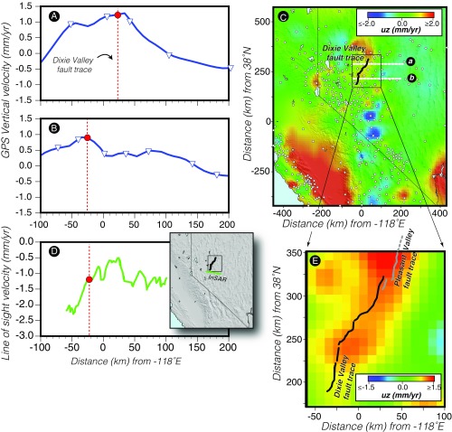
In the Basin and Range extensional province of the western United States, coseismic offsets, under the influence of gravity, display predominantly subsidence of the basin side (fault hanging wall), with comparatively little or no uplift of the mountainside (fault footwall). A few decades later, geodetic measurements [GPS and interferometric synthetic aperture radar (InSAR)] show broad (∼100 km) aseismic uplift symmetrically spanning the fault zone. Finally, after millions of years and hundreds of fault offsets, the mountain blocks display large uplift and tilting over a breadth of only about 10 km. These sparse but robust observations pose a problem in that the coesismic uplifts of the footwall are small and inadequate to raise the mountain blocks. To address this paradox we develop finite-element models subjected to extensional and gravitational forces to study time-varying deformation associated with normal faulting. Stretching the model under gravity demonstrates that asymmetric slip via collapse of the hanging wall is a natural consequence of coseismic deformation. Focused flow in the upper mantle imposed by deformation of the lower crust localizes uplift, which is predicted to take place within one to two decades after each large earthquake. Thus, the best-preserved topographic signature of earthquakes is expected to occur early in the postseismic period.

Keywords: Basin and Range; crustal deformation; earthquakes; finite-element modeling; rifting.


Conflict of interest statement

The authors declare no conflict of interest.

Figures

Fig. 1.
Fig. 1.
Characteristic basin and range topography, with narrow chains of ranges interspersed by basins. (Upper, Inset) Cross-section model of the Warner Range and its bent range front (3, 35). (Lower) The range blocks are bent as a result of repeated faulting along their fronts rather than being tilted. In this example, a single block is faced on either side by normal faults, has no significant internal faulting, and both sides are bent upward (36).
Fig. 2.
Fig. 2.
Geodetic measures of central Basin and Range Province uplift during the past two decades (5, 6). Uplift tends to be symmetric around relatively recently ruptured faults (1954 in this case), which differs from the sharp topographic signal marked by range-front faults (Fig. 1). A and B show west-to-east uplift profiles vs. distance along the transects marked a and b on the map panel in C. An InSAR profile is also shown in D, and a close-up contour map around the Dixie Valley fault is shown in E.
Fig. 3.
Fig. 3.
Observations of coseismic deformation. In these three examples where there exist pre- and postearthquake leveling lines (10, 12), it is evident that the coseismic vertical deformation consists almost entirely of subsidence of the hanging walls (basins). Virtually no range uplift is observed, which is counter to the bent and elevated ranges observed in the topography (Fig. 1).
Fig. 4.
Fig. 4.
Conceptual model that describes faulting of an elastic crust under extension floating in a denser, ductile substrate. (A) A downward-directed gravitational load combined with expanding lateral boundaries causes elastic stretching of the brittle upper crust in an extending tectonic setting. The net density is decreased in any fixed reference crustal section as a result. (B) Frictional resistance on a normal fault is overcome and an earthquake occurs. That rupture concentrates the previously distributed density decrease into the volume that contains the fault. (C) The hanging wall (basin side) collapses during the earthquake, and the volume containing the fault tries to float upward because it is suddenly less dense. (D) Ductile rock flows in beneath the faulted region as a new isostatic balance is achieved, and the faulted region bulges upward.
Fig. 5.
Fig. 5.
Numerical model of normal fault behavior (21). (A) The model consists of three layers: a 15-km-thick elastic but breakable upper crust, a 15-km-thick ductile lower-crustal layer, and a ductile upper mantle thick enough (170 km) that its boundaries do not affect the solution. A 45° dipping normal fault is embedded in the upper crust in the middle of the model that continues as a shear zone into the lower crust. The model can collapse under gravity when its edges are allowed to expand. (B) The model matches observed coseismic subsidence of the fault hanging wall, and stability of the fault foot wall. (C) In a subsequent test, a 1-m slip event on the fault is imposed, which is equivalent to an M ∼ 7 earthquake. The fault is immediately locked, and the postseismic isostatic effects are calculated for a period 10 y after the earthquake. Strong uplift forces beneath the fault footwall are predicted. Localized variability in vector directions in the upper crust is caused by element fracture. (D) By 60 y after the earthquake (∼present-day observation period after the 1954 Nevada earthquake series), the model predicts a broader uplift effect that spans ∼100 km either side of the fault, and that (E) agrees (red dots show modeled uplift rates) with GPS observations (blue dots with measurement uncertainties plotted as error bars). Outlier points are the result of plastic element fracture in the upper crust. (F) A model of long-term extensional faulting is shown, where the fault is allowed to slip continuously, simulating many earthquakes. This results in the uplifted bent range fronts that characterize the Basin and Range province.

References

    1. Colgan JP, Dumitru TA, Miller EL. Diachroneity of Basin and Range extension and Yellowstone hotspot volcanism in northwestern Nevada. Geology. 2004;32:121–124.
    1. Martel SJ, Stock GM, Ito G. Mechanics of relative and absolute displacements across normal faults, and implications for uplift and subsidence along the eastern escarpment of the Sierra Nevada, California. Geosphere. 2014;10:243–263.
    1. Colgan JP, Shuster DL, Reiners PW. Two-phase Neogene extension in the northwestern Basin and Range recorded in a single thermochronology sample. Geology. 2008;36:631–634.
    1. Compton RR. Analysis of Pliocene-Pleistocene deformation and stresses in northern Santa Lucia Range, California. Bull Geol Soc Am. 1966;77:1361–1380.
    1. Hammond WC, Blewitt G, Li Z, Plag H-P, Kreemer C. Contemporary uplift of the Sierra Nevada, western United States, from GPS and InSAR measurements. Geology. 2012;40:667–670.

LinkOut - more resources