

Changes of forest cover and disturbance regimes in the mountain forests of the Alps
- PMID: 28860675
- PMCID: PMC5572777
- DOI: 10.1016/j.foreco.2016.10.028
Changes of forest cover and disturbance regimes in the mountain forests of the Alps
Abstract
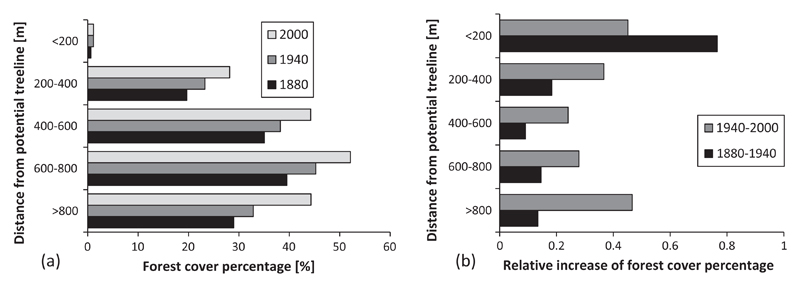
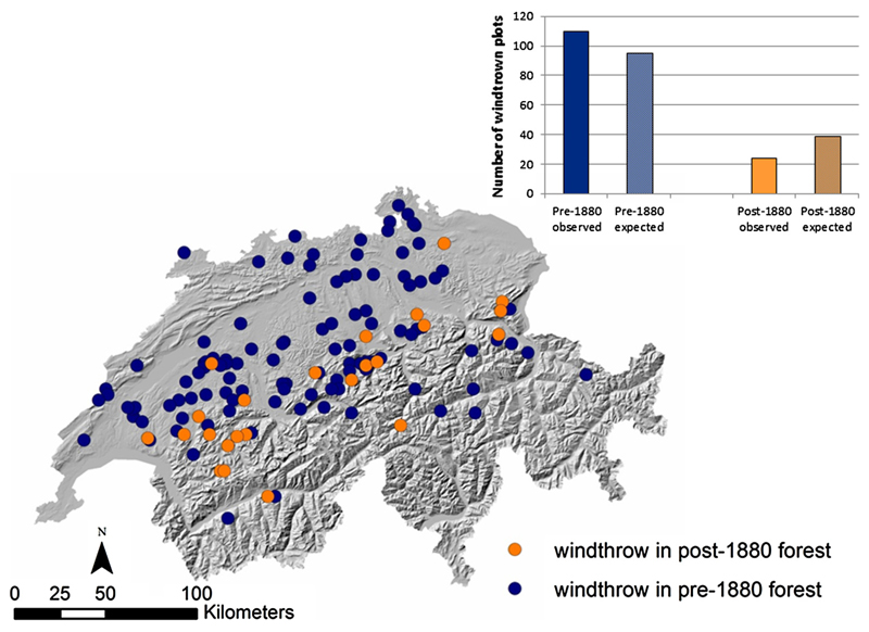
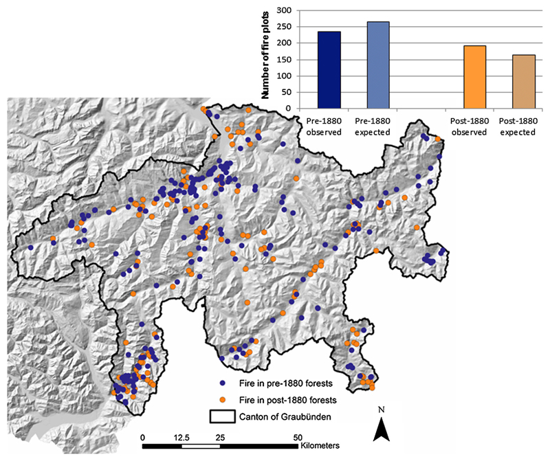
Natural disturbances, such as avalanches, snow breakage, insect outbreaks, windthrow or fires shape mountain forests globally. However, in many regions over the past centuries human activities have strongly influenced forest dynamics, especially following natural disturbances, thus limiting our understanding of natural ecological processes, particularly in densely-settled regions. In this contribution we briefly review the current understanding of changes in forest cover, forest structure, and disturbance regimes in the mountain forests across the European Alps over the past millennia. We also quantify changes in forest cover across the entire Alps based on inventory data over the past century. Finally, using the Swiss Alps as an example, we analyze in-depth changes in forest cover and forest structure and their effect on patterns of fire and wind disturbances, based on digital historic maps from 1880, modern forest cover maps, inventory data on current forest structure, topographical data, and spatially explicit data on disturbances. This multifaceted approach presents a long-term and detailed picture of the dynamics of mountain forest ecosystems in the Alps. During pre-industrial times, natural disturbances were reduced by fire suppression and land-use, which included extraction of large amounts of biomass that decreased total forest cover. More recently, forest cover has increased again across the entire Alps (on average +4% per decade over the past 25-115 years). Live tree volume (+10% per decade) and dead tree volume (mean +59% per decade) have increased over the last 15-40 years in all regions for which data were available. In the Swiss Alps secondary forests that established after 1880 constitute approximately 43% of the forest cover. Compared to forests established previously, post-1880 forests are situated primarily on steep slopes (>30°), have lower biomass, a more aggregated forest structure (primarily stem-exclusion stage), and have been more strongly affected by fires, but less affected by wind disturbance in the 20th century. More broadly, an increase in growing stock and expanding forest areas since the mid-19th century have - along with climatic changes - contributed to an increasing frequency and size of disturbances in the Alps. Although many areas remain intensively managed, the extent, structure, and dynamics of the forests of the Alps reflect natural drivers more strongly today than at any time in the past millennium.
Keywords: Disturbance interactions; European Alps; Forest fire; Land-use history; Secondary succession; Snow avalanches; Windthrow.
Figures


References
-
- Abegg M, Brändli U-B, Cioldi F, Fischer C, Herold-Bonardi A, Huber M, Keller M, Meile R, Rösler E, Speich S, Traub B, et al. Viertes Schweizerisches Landesforstinventar – Ergebnistabellen und Karten des LFIs 2009-2013 (LFI4b) Birmensdorf: Eidg. Forschungsanstalt WSL; 2014. [accessed 10.02.16]. < http://www.lfi.ch/resultate/> [Published online 06.11.2014]
-
- Ammer C. Impact of ungulates on structure and dynamics of natural regeneration of mixed mountain forests in the Bavarian Alps. For Ecol Manage. 1996;88:43–53.
-
- Arpaci A, Malowerschnig B, Sass O, Vacik H. Using multi variate data mining techniques for estimating fire susceptibility of Tyrolean forests. Appl Geogr. 2015;53:258–270.
-
- Ascoli D, Castagneri D, Valsecchi C, Conedera M, Bovio G. Post-fire restoration of beech stands in the Southern Alps by natural regeneration. Ecol Eng. 2013;54:210–217.
-
- Arndt NA, Vacik HA, Koch VA, Arpaci AA, Gossow H. Modeling human-caused forest fire ignition for assessing forest fire danger in Austria. iForest – Biogeosci Forest. 2013;6:315–325.
Grants and funding
LinkOut - more resources
Full Text Sources
Other Literature Sources
Miscellaneous