

Spatially explicit multi-threat assessment of food tree species in Burkina Faso: A fine-scale approach
- PMID: 28880962
- PMCID: PMC5589249
- DOI: 10.1371/journal.pone.0184457
Spatially explicit multi-threat assessment of food tree species in Burkina Faso: A fine-scale approach
Erratum in
-
Correction: Spatially explicit multi-threat assessment of food tree species in Burkina Faso: A fine-scale approach.PLoS One. 2018 Jan 2;13(1):e0190760. doi: 10.1371/journal.pone.0190760. eCollection 2018. PLoS One. 2018. PMID: 29293691 Free PMC article.
Abstract
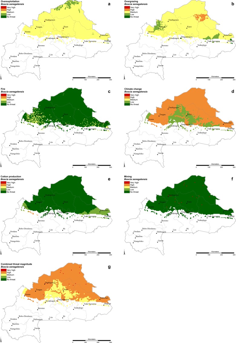
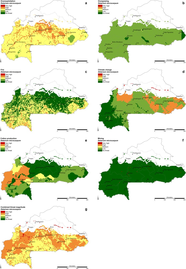
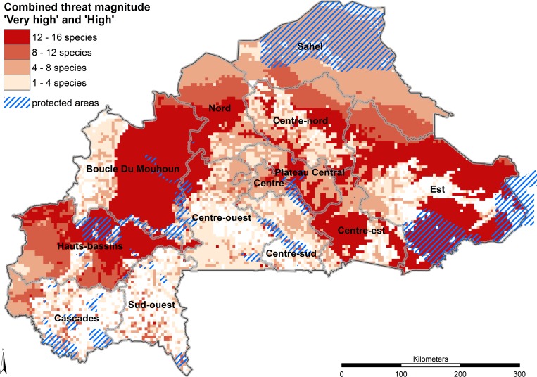
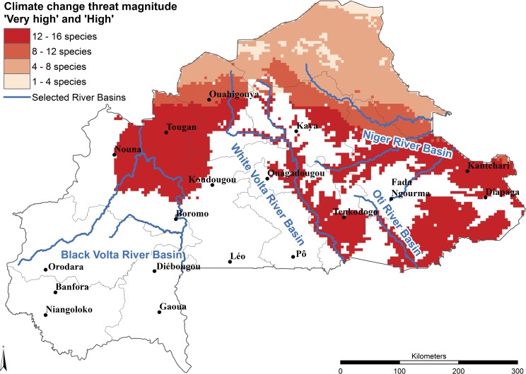
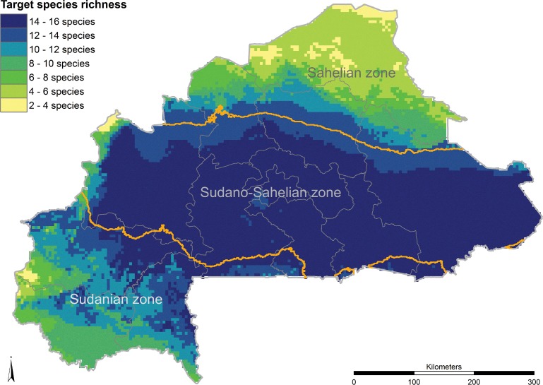
Over the last decades agroforestry parklands in Burkina Faso have come under increasing demographic as well as climatic pressures, which are threatening indigenous tree species that contribute substantially to income generation and nutrition in rural households. Analyzing the threats as well as the species vulnerability to them is fundamental for priority setting in conservation planning. Guided by literature and local experts we selected 16 important food tree species (Acacia macrostachya, Acacia senegal, Adansonia digitata, Annona senegalensis, Balanites aegyptiaca, Bombax costatum, Boscia senegalensis, Detarium microcarpum, Lannea microcarpa, Parkia biglobosa, Sclerocarya birrea, Strychnos spinosa, Tamarindus indica, Vitellaria paradoxa, Ximenia americana, Ziziphus mauritiana) and six key threats to them (overexploitation, overgrazing, fire, cotton production, mining and climate change). We developed a species-specific and spatially explicit approach combining freely accessible datasets, species distribution models (SDMs), climate models and expert survey results to predict, at fine scale, where these threats are likely to have the greatest impact. We find that all species face serious threats throughout much of their distribution in Burkina Faso and that climate change is predicted to be the most prevalent threat in the long term, whereas overexploitation and cotton production are the most important short-term threats. Tree populations growing in areas designated as 'highly threatened' due to climate change should be used as seed sources for ex situ conservation and planting in areas where future climate is predicting suitable habitats. Assisted regeneration is suggested for populations in areas where suitable habitat under future climate conditions coincides with high threat levels due to short-term threats. In the case of Vitellaria paradoxa, we suggest collecting seed along the northern margins of its distribution and considering assisted regeneration in the central part where the current threat level is high due to overexploitation. In the same way, population-specific recommendations can be derived from the individual and combined threat maps of the other 15 food tree species. The approach can be easily transferred to other countries and can be used to analyze general and species specific threats at finer and more local as well as at broader (continental) scales in order to plan more selective and efficient conservation actions in time. The concept can be applied anywhere as long as appropriate spatial data are available as well as knowledgeable experts.
Conflict of interest statement
Figures
References
-
- UNDP (United Nations Development Programme). Human Development Report. 2015. http://hdr.undp.org/sites/default/files/2015_human_development_report.pdf. (accessed 20.04.2016).
-
- Fischer C, Kleinn C, Fehrmann L, Fuchs H, Panferov O. A national level forest resource assessment for Burkina Faso–A field based forest inventory in a semiarid environment combining small sample size with large observation plots. Forest Ecology and Management. 2011;262:1532–1540.
-
- Zizka A, Thiombiano A, Dressler S, Nacoulma B, Ouedraogo A, Ouedraogo I, et al. Traditional plant use in Burkina Faso (West Africa): a national-scale analysis with focus on traditional medicine. Journal of Ethnobiology and Ethnomedicine. 2015;11:9 doi: 10.1186/1746-4269-11-9 - DOI - PMC - PubMed
-
- Somé L, Jalloh A, Zougmoré R, Nelson GC, Thomas TS. Burkina Faso. Chapter 4 in West African Agriculture and Climate Change: A Comprehensive Analysis. IFPRI Research Monograph. 2013. pp. 79–110.
-
- Boffa JM. Agroforestry parklands in sub-Saharan Africa. FAO Conservation Guide. 1999;34:1–230. http://www.fao.org/docrep/005/x3940e/x3940e00.htm.
MeSH terms
LinkOut - more resources
Full Text Sources
Other Literature Sources
