

Population stress: A spatiotemporal analysis of population change and land development at the county level in the contiguous United States, 2001-2011
- PMID: 29097829
- PMCID: PMC5662015
- DOI: 10.1016/j.landusepol.2017.10.008
Population stress: A spatiotemporal analysis of population change and land development at the county level in the contiguous United States, 2001-2011
Abstract
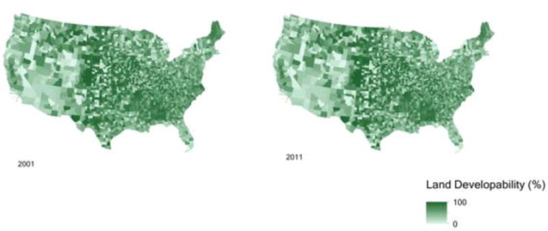
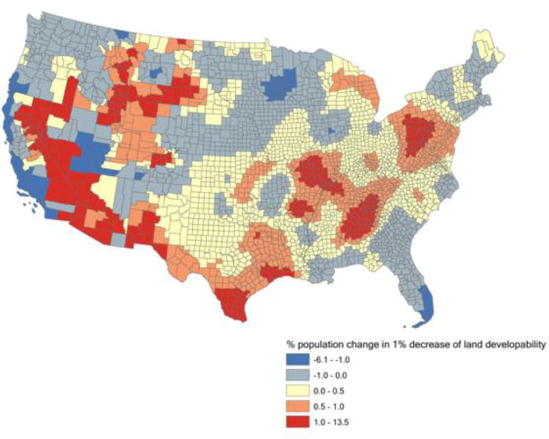
The past century has witnessed rapidly increasing population-land conflicts due to exponential population growth and its many consequences. Although the measures of population-land conflicts are many, there lacks a model that appropriately considers both the social and physical contexts of population-land conflicts. In this study we introduce the concept of population stress, which identifies areas with populations growing faster than the lands available for sustainable development. Specifically, population stress areas are identified by comparing population growth and land development as measured by land developability in the contiguous United States from 2001 to 2011. Our approach is based on a combination of spatial multicriteria analysis, zonal statistics, and spatiotemporal modeling. We found that the population growth of a county is associated with the decrease of land developability, along with the spatial influences of surrounding counties. The Midwest and the traditional "Deep South" counties would have less population stress with future land development, whereas the Southeast Coast, Washington State, Northern Texas, and the Southwest would face more stress due to population growth that is faster than the loss of suitable lands for development. The factors contributing to population stress may differ from place to place. Our population stress concept is useful and innovative for understanding population stress due to land development and can be applied to other regions as well as global research. It can act as a basis towards developing coherent sustainable land use policies. Coordination among local governments and across different levels of governments in the twenty-first century is a must for effective land use planning.
Keywords: Land developability; Population growth; Population stress; Population-land conflicts; Vulnerability.
Figures


References
-
- Albert RJ, Lishman JM, Saxena JR. Ballast water regulations and the move toward concentration-based numeric discharge limits. Ecological Applications. 2013;23(2):289–300. - PubMed
-
- Alexakis DD, Grillakis MG, Koutroulis AG, Agapiou A, Themistocleous K, Tsanis IK, Retalis A. GIS and remote sensing techniques for the assessment of land use change impact on flood hydrology: The case study of Yialias basin in Cyprus. Natural Hazards and Earth System Sciences. 2014;14(2):413–426.
-
- Angelo H, Wachsmuth D. Urbanizing urban political ecology: A critique of methodological cityism. International Journal of Urban and Regional Research. 2015;39(1):16–27.
-
- Anselin L. Local indicators of spatial association—LISA. Geographical Analysis. 1995;27(2):93–115.
-
- Anselin L, Syabri I, Kho Y. GeoDa: An introduction to spatial data analysis. Geographical Analysis. 2006;38(1):5–22.
Grants and funding
LinkOut - more resources
Full Text Sources
Other Literature Sources
Miscellaneous