. 2017 Nov 17;11(11):e0006070.
doi: 10.1371/journal.pntd.0006070. eCollection 2017 Nov.

The introduction of dengue follows transportation infrastructure changes in the state of Acre, Brazil: A network-based analysis

Affiliations

The introduction of dengue follows transportation infrastructure changes in the state of Acre, Brazil: A network-based analysis

Raquel Martins Lana et al. PLoS Negl Trop Dis. .

Abstract

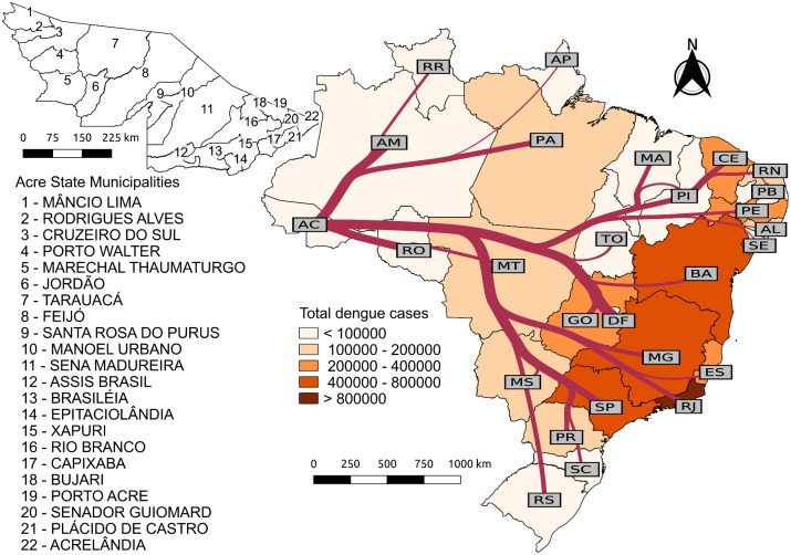
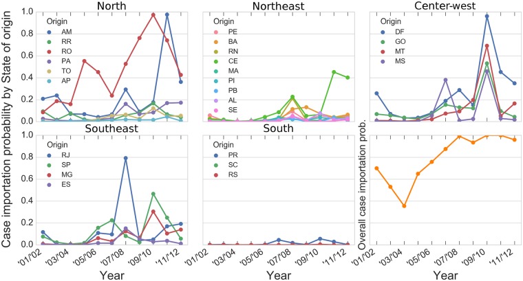
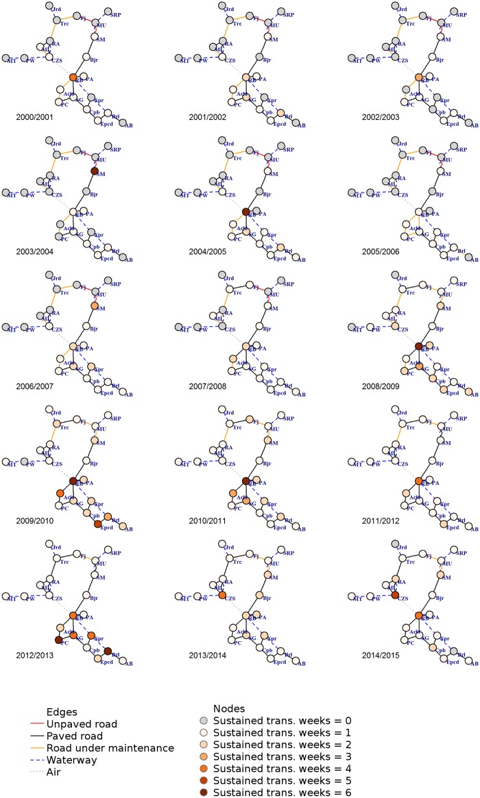
Human mobility, presence and passive transportation of Aedes aegypti mosquito, and environmental characteristics are a group of factors which contribute to the success of dengue spread and establishment. To understand this process, we assess data from dengue national and municipal basins regarding population and demographics, transportation network, human mobility, and Ae. aegypti monitoring for the Brazilian state of Acre since the first recorded dengue case in the year 2000 to the year 2015. During this period, several changes in Acre's transport infrastructure and urbanization have been started. To reconstruct the process of dengue introduction in Acre, we propose an analytic framework based on concepts used in malaria literature, namely vulnerability and receptivity, to inform risk assessments in dengue-free regions as well as network theory concepts for disease invasion and propagation. We calculate the probability of dengue importation to Acre from other Brazilian states, the evolution of dengue spread between Acrean municipalities and dengue establishment in the state. Our findings suggest that the landscape changes associated with human mobility have created favorable conditions for the establishment of dengue virus transmission in Acre. The revitalization of its major roads, as well as the increased accessibility by air to and within the state, have increased dengue vulnerability. Unplanned urbanization and population growth, as observed in Acre during the period of study, contribute to ideal conditions for Ae. aegypti mosquito establishment, increase the difficulty in mosquito control and consequently its local receptivity.


Conflict of interest statement

The authors have declared that no competing interests exist.

Figures

Fig 1
Fig 1. Dengue cases in Brazilian states and airline flow to the state of Acre.
The map is colored according to the total number of reported dengue cases in each state during the period of this study (from dengue epidemiological year 2001/2002 to 2011/2012). The left panel shows the municipalities of the state of Acre. The network over the country map on the right panel represents the flow of airline passengers to Acre from each state. Edges widths are proportional to the logarithm of the total number of passengers from 2001/2002 to 2011/2012. The underlying shapefiles with political boundaries of Brazilian states and municipalities used to build this figure are publicly available and free to use at Instituto Brasileiro de Geografia e Estatística (IBGE, Brazilian Institute of Geography and Statistics) website http://downloads.ibge.gov.br/downloads_geociencias.htm.
Fig 2
Fig 2. Probability of at least one dengue-infected individual traveling to Acre by state of origin during his/her infectious period, per year.
Each panel refers to states within each Brazilian geopolitical Region. The panel on the bottom right shows the overall probability of at least one case importation, regardless of state of origin, as in Eq 3.
Fig 3
Fig 3. Weeks with Rt > 1 from July 2000 to July 2015.
(A) Weeks with Rt > 1 from July 1st, 2000, to June 30th, 2007. (B) Weeks with Rt > 1 from July 1st, 2007, to June 30th, 2015. Each line on the vertical axis corresponds to a municipality in the state of Acre. Black: municipalities accessible by paved roads during all or almost all the time of the study. Gray: city (CZS) served by airline from Rio Branco. Orange: municipalities partially or totally accessible via unpaved or under maintenance roads. Blue: municipalities whose access necessarily include waterways. Refer to Table 2 for municipalities’ name.
Fig 4
Fig 4. Mobility network between Acrean municipalities.
Each node represents a municipality, with its size proportional to the natural logarithm of the population. Edges represent the average flow of individuals between municipalities, with width and color proportional to the natural logarithm of the number of travelers. Node color follows the same criteria as in Fig 3: (black) municipalities connected by paved roads, (gray) municipality with air connection to RB, (orange) municipalities connected by highway BR-364 with unpaved or maintenance sections during the period of study, (blue) municipalities that are mainly accessed by river.
Fig 5
Fig 5. Structural networks time series in epidemiologic years.
Nodes (circles) are the 22 municipalities of the state of Acre in which gray nodes are municipalities with Rt < 1. Colored nodes are the representations of Rt > 1 by the number of consecutive weeks per year, varying in shades of orange for at least one week (lighter) to six consecutive weeks (darker), with gray color for years with no such event in any week. Edges (lines) are the direct connections between municipalities by modal type category: roads (unpaved in red, paved in black, under maintenance or construction in orange), waterway in dark blue dashed line and air in dotted gray line. This figure is provided in higher resolution in supplementary information S1 Fig.
Fig 6
Fig 6. Centrality measures and dengue establishment.
Boxplots comparing the network descriptors of municipalities that witnessed dengue establishment during the study period and those which did not (Yes/No). Values for each Municipality are available in S2 Appendix.

References

    1. Stoddard ST, Forshey BM, Morrison AC, Paz-Soldan VA, Vazquez-Prokopec GM, Astete H, et al. House-to-house human movement drives dengue virus transmission. Proceedings of the National Academy of Sciences of the United States of America. 2013;110:994–999. doi: 10.1073/pnas.1213349110 - DOI - PMC - PubMed
    1. Kuno G. Review of the factors modulating dengue transmission. Epidemiologic reviews. 1995;17:321–335. doi: 10.1093/oxfordjournals.epirev.a036196 - DOI - PubMed
    1. Honório NA, Silva WdC, Leite PJ, Gonçalves JM, Lounibos LP, Lourenço-de Oliveira R. Dispersal of Aedes aegypti and Aedes albopictus (Diptera: Culicidae) in an urban endemic dengue area in the State of Rio de Janeiro, Brazil. Memórias do Instituto Oswaldo Cruz. 2003;98(2):191–198. doi: 10.1590/S0074-02762003000200005 - DOI - PubMed
    1. Gubler D, Kuno G. Dengue and dengue hemorrhagic fever: its history and resurgence as a global public health problem, p 1-22. Dengue and dengue hemorrhagic fever CAB international, London, United Kingdom. 1997.
    1. Smith CEG. The History of Dengue in Tropical Asia and its Probable Relationship to the Mosquito Aedes aegypti. Journal of Tropical Medicine and Hygiene. 1956;59(10):243–51. - PubMed