

The "Tracked Roaming Transect" and distance sampling methods increase the efficiency of underwater visual censuses
- PMID: 29324887
- PMCID: PMC5764311
- DOI: 10.1371/journal.pone.0190990
The "Tracked Roaming Transect" and distance sampling methods increase the efficiency of underwater visual censuses
Abstract
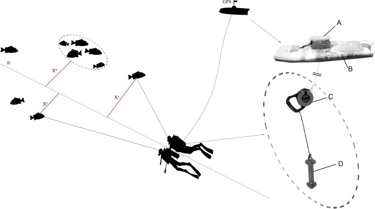
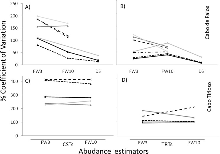
Underwater visual census (UVC) is the most common approach for estimating diversity, abundance and size of reef fishes in shallow and clear waters. Abundance estimation through UVC is particularly problematic in species occurring at low densities and/or highly aggregated because of their high variability at both spatial and temporal scales. The statistical power of experiments involving UVC techniques may be increased by augmenting the number of replicates or the area surveyed. In this work we present and test the efficiency of an UVC method based on diver towed GPS, the Tracked Roaming Transect (TRT), designed to maximize transect length (and thus the surveyed area) with respect to diving time invested in monitoring, as compared to Conventional Strip Transects (CST). Additionally, we analyze the effect of increasing transect width and length on the precision of density estimates by comparing TRT vs. CST methods using different fixed widths of 6 and 20 m (FW3 and FW10, respectively) and the Distance Sampling (DS) method, in which perpendicular distance of each fish or group of fishes to the transect line is estimated by divers up to 20 m from the transect line. The TRT was 74% more time and cost efficient than the CST (all transect widths considered together) and, for a given time, the use of TRT and/or increasing the transect width increased the precision of density estimates. In addition, since with the DS method distances of fishes to the transect line have to be estimated, and not measured directly as in terrestrial environments, errors in estimations of perpendicular distances can seriously affect DS density estimations. To assess the occurrence of distance estimation errors and their dependence on the observer's experience, a field experiment using wooden fish models was performed. We tested the precision and accuracy of density estimators based on fixed widths and the DS method. The accuracy of the estimates was measured comparing the actual total abundance with those estimated by divers using FW3, FW10, and DS estimators. Density estimates differed by 13% (range 0.1-31%) from the actual values (average = 13.09%; median = 14.16%). Based on our results we encourage the use of the Tracked Roaming Transect with Distance Sampling (TRT+DS) method for improving density estimates of species occurring at low densities and/or highly aggregated, as well as for exploratory rapid-assessment surveys in which divers could gather spatial ecological and ecosystem information on large areas during UVC.
Conflict of interest statement
Figures
References
-
- Willis TJ, Anderson MJ. Structure of cryptic reef fish assemblages: relationships with habitat characteristics and predator density. Mar Ecol Prog Ser. 2003; 257: 209–221.
-
- Cappo MC, Harvey ES, Shortis M. Counting and measuring fish with baited video techniques—an overview. In: Furlani D, Beumer JP, editors. Proceedings of the Australian Society for Fish Biology Workshop, Hobart, Australia. 2007 pp. 101–114.
-
- Polunin NVC, Bloomfield HJ, Sweeting CJ, McCandless DT. Developing indicators of MPA effectiveness: finfish abundance and diversity in a Yorkshire prohibited trawl area, Report to MFA, London. 2009.
-
- Colton MA, Swearer SE. A comparison of two survey methods: differences between underwater visual census and baited remote underwater video. Mar Ecol Prog Ser. 2010; 400: 19–36.
-
- Katsanevakis S, Weber A, Pipitone C, Leopold M, Cronin M, Scheidat M, et al. Monitoring marine populations and communities: methods dealing with imperfect detectability. Aquat Biol. 2012; 16: 31–52.
Publication types
MeSH terms
LinkOut - more resources
Full Text Sources
Other Literature Sources
