

Enrichment of OpenStreetMap Data Completeness with Sidewalk Geometries Using Data Mining Techniques
- PMID: 29419768
- PMCID: PMC5854971
- DOI: 10.3390/s18020509
Enrichment of OpenStreetMap Data Completeness with Sidewalk Geometries Using Data Mining Techniques
Abstract
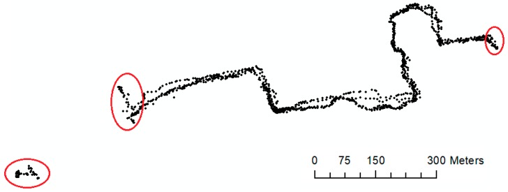
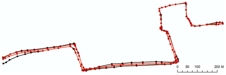
Tailored routing and navigation services utilized by wheelchair users require certain information about sidewalk geometries and their attributes to execute efficiently. Except some minor regions/cities, such detailed information is not present in current versions of crowdsourced mapping databases including OpenStreetMap. CAP4Access European project aimed to use (and enrich) OpenStreetMap for making it fit to the purpose of wheelchair routing. In this respect, this study presents a modified methodology based on data mining techniques for constructing sidewalk geometries using multiple GPS traces collected by wheelchair users during an urban travel experiment. The derived sidewalk geometries can be used to enrich OpenStreetMap to support wheelchair routing. The proposed method was applied to a case study in Heidelberg, Germany. The constructed sidewalk geometries were compared to an official reference dataset ("ground truth dataset"). The case study shows that the constructed sidewalk network overlays with 96% of the official reference dataset. Furthermore, in terms of positional accuracy, a low Root Mean Square Error (RMSE) value (0.93 m) is achieved. The article presents our discussion on the results as well as the conclusion and future research directions.
Keywords: OpenStreetMap; completeness; data quality; open data; routing; sidewalk.
Conflict of interest statement
The authors declare no conflict of interest.
Figures


References
-
- Haklay M., Weber P. Openstreetmap: User-generated street maps. IEEE Pervasive Comput. 2008;7:12–18. doi: 10.1109/MPRV.2008.80. - DOI
-
- See L., Mooney P., Foody G., Bastin L., Comber A., Estima J., Liu H.Y. Crowdsourcing, citizen science or volunteered geographic information? The current state of crowdsourced geographic information. ISPRS Int. J. Geo Inf. 2016;5:55. doi: 10.3390/ijgi5050055. - DOI
-
- Goodchild M.F., Li L. Assuring the quality of volunteered geographic information. Spat. Stat. 2012;1:110–120. doi: 10.1016/j.spasta.2012.03.002. - DOI
-
- Senaratne H., Mobasheri A., Ali A.L., Capineri C., Haklay M. A review of volunteered geographic information quality assessment methods. Int. J. Geogr. Inf. Sci. 2017;31:139–167. doi: 10.1080/13658816.2016.1189556. - DOI
-
- Girres J.F., Touya G. Quality assessment of the French OpenStreetMap dataset. Trans. GIS. 2010;14:435–459. doi: 10.1111/j.1467-9671.2010.01203.x. - DOI
LinkOut - more resources
Full Text Sources
Other Literature Sources
