. 2018 Mar 13;115(11):2664-2669.
doi: 10.1073/pnas.1800141115. Epub 2018 Feb 28.

Direct observations of rock moisture, a hidden component of the hydrologic cycle

Affiliations

Direct observations of rock moisture, a hidden component of the hydrologic cycle

Daniella M Rempe et al. Proc Natl Acad Sci U S A. .

Abstract

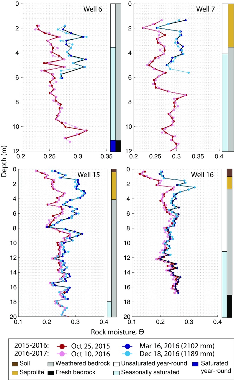
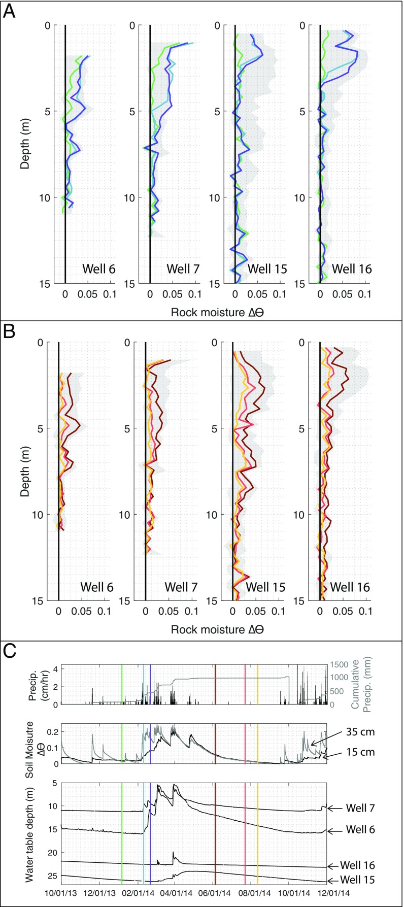
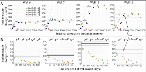
Recent theory and field observations suggest that a systematically varying weathering zone, that can be tens of meters thick, commonly develops in the bedrock underlying hillslopes. Weathering turns otherwise poorly conductive bedrock into a dynamic water storage reservoir. Infiltrating precipitation typically will pass through unsaturated weathered bedrock before reaching groundwater and running off to streams. This invisible and difficult to access unsaturated zone is virtually unexplored compared with the surface soil mantle. We have proposed the term "rock moisture" to describe the exchangeable water stored in the unsaturated zone in weathered bedrock, purposely choosing a term parallel to, but distinct from, soil moisture, because weathered bedrock is a distinctly different material that is distributed across landscapes independently of soil thickness. Here, we report a multiyear intensive campaign of quantifying rock moisture across a hillslope underlain by a thick weathered bedrock zone using repeat neutron probe measurements in a suite of boreholes. Rock moisture storage accumulates in the wet season, reaches a characteristic upper value, and rapidly passes any additional rainfall downward to groundwater. Hence, rock moisture storage mediates the initiation and magnitude of recharge and runoff. In the dry season, rock moisture storage is gradually depleted by trees for transpiration, leading to a common lower value at the end of the dry season. Up to 27% of the annual rainfall is seasonally stored as rock moisture. Significant rock moisture storage is likely common, and yet it is missing from hydrologic and land-surface models used to predict regional and global climate.

Keywords: Critical Zone; deep vadose zone; evapotranspiration; rock moisture; water budget.


Conflict of interest statement

The authors declare no conflict of interest.

Figures

Fig. 1.
Fig. 1.
Rock moisture storage within a hillslope: Cross-section of the study hillslope (latitude 39°43′44″N, longitude 123°38′39″W; Fig. S1) illustrating the Critical Zone structure, which extends from the tree canopy (green points reflecting lidar-derived canopy structure) to unweathered (i.e., fresh) bedrock (illustrated in dark gray). Well locations (vertical dashed lines) are projected onto the hillslope profile which extends across Elder Creek (Fig. S1). Three additional wells (wells 1, 3 and 10; shown in Fig. S1) were used to construct this weathering profile and hydrologic profile, but were not available for rock moisture monitoring. Rock moisture is stored between the base of the soil (soil thickness is similar to the scale of the brown dots denoting the ground surface) and the seasonally saturated zone, which is bounded by the minimum and maximum water table positions (approximate location derived from groundwater monitoring shown as blue dashed lines). In some cases, storage of rock moisture occurs below the seasonal maximum water table position. Inset is a conceptual vertical weathering profile illustrating thin soil overlying weathered bedrock which transitions to fresh bedrock at the base of the weathering profiles. (Lidar provided by the National Center for Airborne Laser Mapping.)
Fig. 2.
Fig. 2.
A structured rock moisture reservoir: Vertical profiles of rock moisture expressed as volumetric water content, θ, in a subset of wells show that similar minimum (red) and maximum (blue) θ is reached in different years. Seasonal cumulative precipitation at the time of the wet-season measurement is shown in parentheses in the legend. Colored vertical bars on the right of each graph illustrate the zone of water table fluctuation identified via groundwater monitoring (left bars) and the weathering profile characteristics identified during drilling (right bars). Borehole locations are shown in Fig. 1 and Fig. S1.
Fig. 3.
Fig. 3.
Seasonal soil moisture, rock moisture, and groundwater dynamics: Vertical profiles of rock moisture change, Δθ, illustrate that in the early wet-season, a wetting front progresses downward before the seasonal rise of the water table (A), while, during the dry season, rock moisture is progressively depleted (B), as groundwater recedes (C). Gray shading marks the total range of Δθ measured over the entire monitoring period (Materials and Methods). Colored lines in A and B correspond to the colored vertical lines marked in the precipitation, soil moisture, and groundwater level time series shown in C. Soil moisture dynamics at two depths near the ridge (15 and 35 cm) and groundwater dynamics in four wells are shown in C, Middle and Bottom. The locations of sensors and wells is shown in Fig. S1.
Fig. 4.
Fig. 4.
Annually consistent patterns of rock moisture storage. (A) In different years (represented by different colors), rock moisture storage, S (mm), increases with increasing cumulative seasonal precipitation, until a maximum rock moisture (Smax) is reached (average and range are shown as thick and thin horizontal lines, respectively; Table S3). Thick red bars mark the range of precipitation when seasonal groundwater first responds at each well (Table S2). S is calculated for all depths that were above the water table at the time of measurement. (B) S declines following the final storm of the wet season. In years with different seasonal cumulative precipitation, the magnitude and timing of decline is roughly similar. The approximate month associated with the time since the end of the wet season is labeled. Other wells are shown in Figs. S3 and S4.

References

    1. Matthes JH, Goring S, Williams JW, Dietze MC. Benchmarking historical CMIP5 plant functional types across the Upper Midwest and Northeastern United States. J Geophys Res Biogeosci. 2016;121:523–535.
    1. Matheny AM, et al. Characterizing the diurnal patterns of errors in the prediction of evapotranspiration by several land-surface models: An NACP analysis. J Geophys Res Biogeosci. 2014;119:1458–1473.
    1. McColl KA, et al. The global distribution and dynamics of surface soil moisture. Nat Geosci. 2017;10:100–104.
    1. Ochsner TE, et al. State of the art in large-scale soil moisture monitoring. Soil Sci Soc Am J. 2013;77:1888–1919.
    1. Fan Y, Miguez-Macho G, Jobbágy EG, Jackson RB, Otero-Casal C. Hydrologic regulation of plant rooting depth. Proc Natl Acad Sci USA. 2017;114:10572–10577. - PMC - PubMed

Publication types

LinkOut - more resources