

Geotechnology in the analysis of forest fragments in northern Mato Grosso, Brazil
- PMID: 29500472
- PMCID: PMC5834460
- DOI: 10.1038/s41598-018-22311-y
Geotechnology in the analysis of forest fragments in northern Mato Grosso, Brazil
Abstract
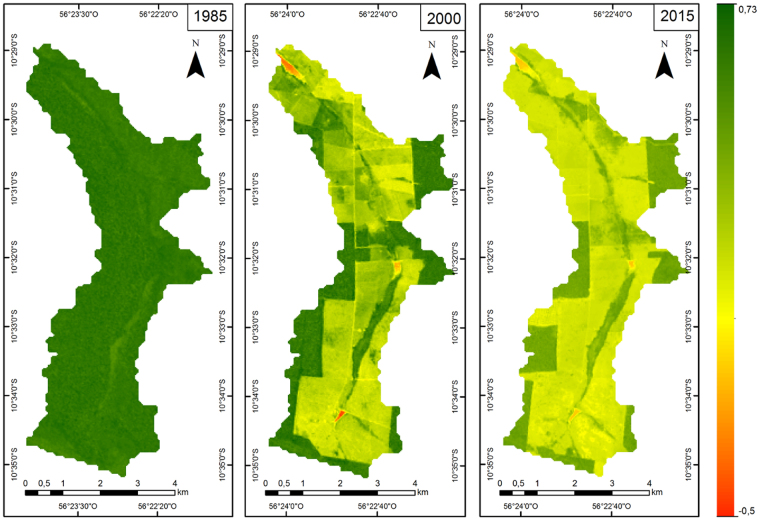
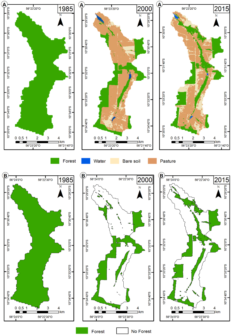
Pasture implantation fragments and reduces the Amazonian forest area. The objective was to quantify landscape changes in 1985, 2000 and 2015 in northern Mato Grosso, Brazil. The study was carried out in three scenes obtained by the LANDSAT satellite of a microbasin (2742.33 ha) in the municipality of Alta Floresta. Forest, water bodies, pasture and exposed soil were the thematic classes determined to e mapping the land use evolution. The edge, density and shape indexes of the fragments were measured. Normalized vegetation difference (NDVI) values were high in 1985. Land use and occupation over 15 years (1985-2000) reduced forest cover by 69.8%, but it increased by 1.7% over the next 15 years (2000-2015). The number of exposed soil patches increased between the periods, but the total area and number of the patches of the forest fragments decreased. The high values of NDVI in 1985 showed vegetated areas with high density. Reducing forest cover decreases the size of the fragments, increases the isolation and the number of soil patches exposed. The mapping of land use showed a reduction of the Amazon forest in the microbasin in the north of Mato Grosso, in the years 2000 and 2015 compared to 1985.
Conflict of interest statement
The authors declare no competing interests.
Figures

References
-
- Mann ML, et al. Pasture conversion and competitive cattle rents in the Amazon. Ecological economics. 2014;97:182–190. doi: 10.1016/j.ecolecon.2013.11.014. - DOI
-
- BRASIL, Código Florestal. Lei n° 12.651, de 25 de maio de 2012. Brasília, Diário Oficial da União http://www.planalto.gov.br/ccivil_03/_ato2011-2014/2012/lei/l12651.htm (2012).
-
- Li Y, et al. Multi-scale assessments of forest fragmentation in China. Biodiversity Science. 2017;25:372–382. doi: 10.17520/biods.2016257. - DOI
-
- Ruviaro CF, et al. Economic and environmental feasibility of beef production in different feed management systems in the Pampa biome, southern Brazil. Ecological Indicators. 2016;60:930–939. doi: 10.1016/j.ecolind.2015.08.042. - DOI
Publication types
MeSH terms
LinkOut - more resources
Full Text Sources
Other Literature Sources
