. 2018 Mar 14;9(1):1065.
doi: 10.1038/s41467-018-03353-2.

Dark zone of the Greenland Ice Sheet controlled by distributed biologically-active impurities

Affiliations

Dark zone of the Greenland Ice Sheet controlled by distributed biologically-active impurities

Jonathan C Ryan et al. Nat Commun. .

Abstract

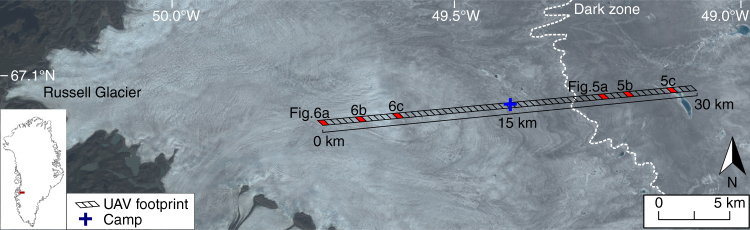
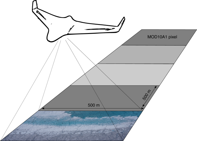
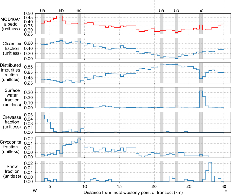
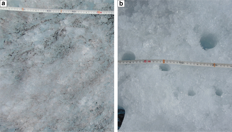
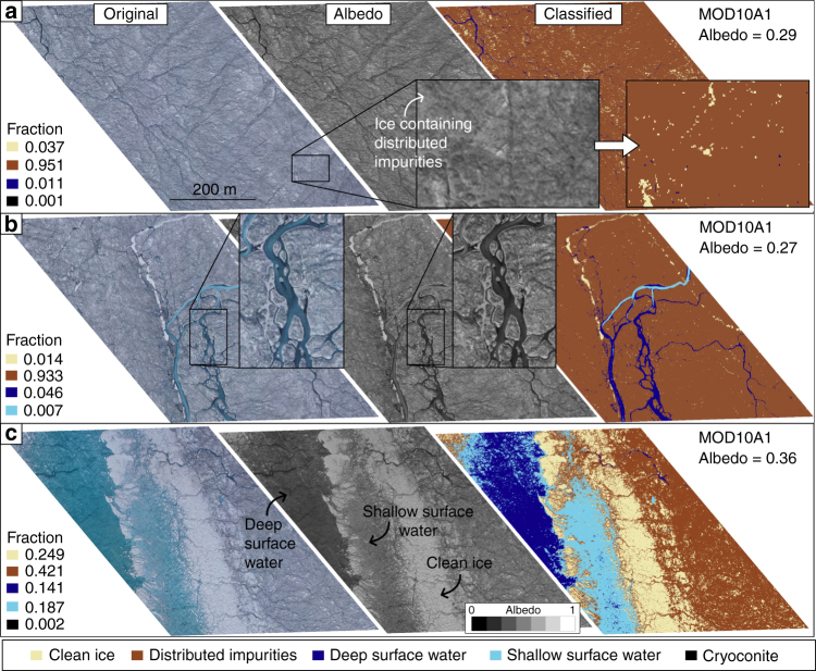
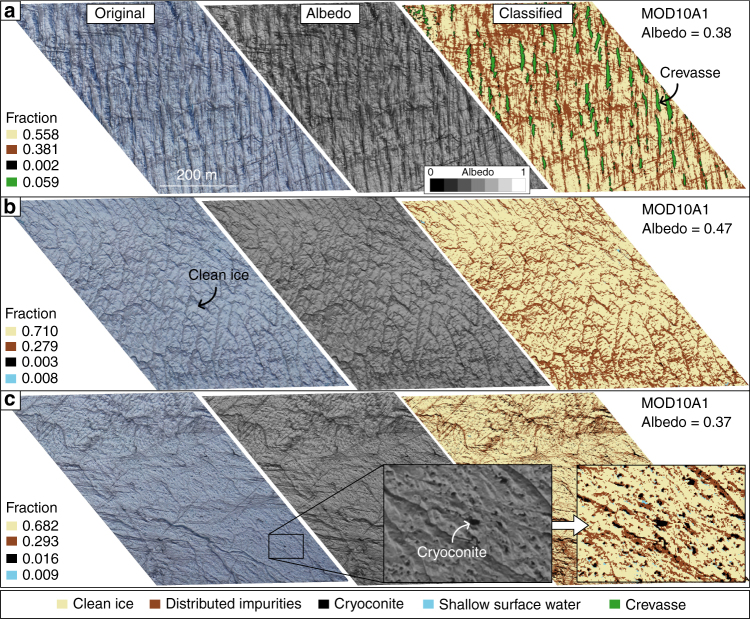
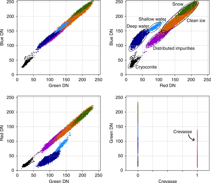
Albedo-a primary control on surface melt-varies considerably across the Greenland Ice Sheet yet the specific surface types that comprise its dark zone remain unquantified. Here we use UAV imagery to attribute seven distinct surface types to observed albedo along a 25 km transect dissecting the western, ablating sector of the ice sheet. Our results demonstrate that distributed surface impurities-an admixture of dust, black carbon and pigmented algae-explain 73% of the observed spatial variability in albedo and are responsible for the dark zone itself. Crevassing and supraglacial water also drive albedo reduction but due to their limited extent, explain just 12 and 15% of the observed variability respectively. Cryoconite, concentrated in large holes or fluvial deposits, is the darkest surface type but accounts for <1% of the area and has minimal impact. We propose that the ongoing emergence and dispersal of distributed impurities, amplified by enhanced ablation and biological activity, will drive future expansion of Greenland's dark zone.


Conflict of interest statement

The authors declare no competing interests.

Figures

Fig. 1
Fig. 1
Overview map showing location of UAV survey transect. The background is a Landsat 8 Operational Land Imager (OLI) true colour image of the Kangerlussuaq sector of the Greenland Ice Sheet from 6 August 2014. The transect was divided into sixty 0.25 km2 segments for comparison with the MODIS albedo product, MOD10A1. High-resolution aerial imagery and surface classification of six segments (coloured red) are shown in Figs. 5 and 6
Fig. 2
Fig. 2
Schematic summarizing the aims of the study. Aerial digital imagery are used to characterize the surface types that are found in the ablation zone and assess their impact on mesoscale spatial albedo patterns as represented by MODIS
Fig. 3
Fig. 3
Variation of albedo and the fractional area of each surface type across the UAV transect. The albedo and fractional areas derived from MOD10A1 and the UAV imagery, respectively, on 8 August 2014. The x axis is displayed in Fig. 1. The results of the classification for six segments, highlighted by the vertical grey bars, are shown in Figs. 5 and 6
Fig. 4
Fig. 4
Photograph showing close-up of bare ice found in the ablation zone. The photographs were taken near the field camp located close to the S6 automated weather station at ~1000 m a.s.l. (Fig. 1). a Ice containing distributed impurities on the surface and b clean ice with cryoconite holes
Fig. 5
Fig. 5
RGB digital image, albedo map and classification of surface types in three MOD10A1 pixels. The albedo maps were derived from the digital images (Methods). The locations of the segments along the UAV transect are shown in Fig. 1. a Segment characterized by mostly ice containing uniformly distributed impurities. b Segment characterized by similar ice surface to a but with a larger fraction of channelized surface melt-water. c Segment dominated by a supraglacial lake with a previous shore consisting of clean ice
Fig. 6
Fig. 6
RGB digital image, albedo map and classification of surface types in three more MOD10A1 pixels. The albedo maps were derived from the digital images (Methods). The locations of the segments along the UAV transect are shown in Fig. 1. a Segment containing a high fraction of crevasses. b Segment characterized by a much lower relief surface and no crevasses. c Segment characterized by clean ice and numerous cryoconite holes
Fig. 7
Fig. 7
Scatter-plots showing the key attributes of the seven surface types identified in this study. DN is digital number of the Sony NEX-5N calibrated RAW image. Deep and shallow supraglacial water is easily distinguishable because it has low reflectivity in the red band and forms a unique cluster in the feature space. Snow, clean ice, ice containing distributed impurities and cryoconite form another cluster and are distinguishable because they reflect different proportions of RGB visible wavelengths

References

    1. Box, J. E. et al. Changes to Arctic land ice. In Snow, Water, Ice and Permafrost in the Arctic (SWIPA) 137–168 (Arctic Monitoring and Assessment Programme (AMAP), Oslo, Norway, 2017).
    1. Hanna E, et al. Ice-sheet mass balance and climate change. Nature. 2013;498:51–59. doi: 10.1038/nature12238. - DOI - PubMed
    1. Enderlin EM, et al. An improved mass budget for the Greenland ice sheet. Geophys. Res. Lett. 2014;41:866–872. doi: 10.1002/2013GL059010. - DOI
    1. van den Broeke MR, et al. On the recent contribution of the Greenland ice sheet to sea level change. Cryosphere. 2016;10:1933–1946. doi: 10.5194/tc-10-1933-2016. - DOI
    1. Gardner AS, Sharp MJ. A review of snow and ice albedo and the development of a new physically based broadband albedo parameterization. J. Geophys. Res. Earth Surf. 2010;115:1–15.

Publication types