. 2018 Apr 25;4(4):eaap9741.
doi: 10.1126/sciadv.aap9741. eCollection 2018 Apr.

Most atolls will be uninhabitable by the mid-21st century because of sea-level rise exacerbating wave-driven flooding

Affiliations

Most atolls will be uninhabitable by the mid-21st century because of sea-level rise exacerbating wave-driven flooding

Curt D Storlazzi et al. Sci Adv. .

Abstract

Sea levels are rising, with the highest rates in the tropics, where thousands of low-lying coral atoll islands are located. Most studies on the resilience of these islands to sea-level rise have projected that they will experience minimal inundation impacts until at least the end of the 21st century. However, these have not taken into account the additional hazard of wave-driven overwash or its impact on freshwater availability. We project the impact of sea-level rise and wave-driven flooding on atoll infrastructure and freshwater availability under a variety of climate change scenarios. We show that, on the basis of current greenhouse gas emission rates, the nonlinear interactions between sea-level rise and wave dynamics over reefs will lead to the annual wave-driven overwash of most atoll islands by the mid-21st century. This annual flooding will result in the islands becoming uninhabitable because of frequent damage to infrastructure and the inability of their freshwater aquifers to recover between overwash events. This study provides critical information for understanding the timing and magnitude of climate change impacts on atoll islands that will result in significant, unavoidable geopolitical issues if it becomes necessary to abandon and relocate low-lying island states.


Figures

Fig. 1
Fig. 1. Conceptual diagram of the influence of SLR on wave heights, wave-driven runup, and flooding and the resulting impact on atoll island groundwater.
(A) Current sea level. (B) Future elevated sea level. SLR will allow for greater wave heights, H, and wave-driven runup, R, than at present, resulting in frequent overwash that will contaminate the atoll island’s freshwater lens. High vertical exaggeration in schematic.
Fig. 2
Fig. 2. The morphology of Roi-Namur Island on Kwajalein Atoll and the impact of the March 2014 large wave event on the island’s oceanography and hydrogeology.
(A) Photograph of the seaward side of Roi-Namur showing the wide coral reef flat and low relief of the island during typical low-energy conditions. (B) Photograph of the seaward side of Roi-Namur showing the wave-driven runup and seawater flooding inland (to the left) during the March 2014 large wave event. (C) Wave heights and wave periods offshore the island during the March 2014 large wave event. (D) Mean seawater levels across the atoll. (E) Instantaneous wave-driven water levels and modeled runup at the seaward shoreline. (F) Groundwater levels at a subset of the monitoring wells. At the peak of the 2 to 3 March large wave event, wave-driven flooding overwashed the seaward portion of the island, raising groundwater levels and salinizing portions of the island’s freshwater lens.
Fig. 3
Fig. 3. The projected spatial extent of inundation due to SLR and annual flooding due to the combined effects of waves and SLR on Roi through time for different SLR and climatic scenarios.
(A) SLR inundation for RCP4.5. (B) SLR inundation for RCP8.5. (C) SLR inundation for RCP8.5+icesheet collapse. (D) Annual wave-driven flooding for RCP4.5. (E) Annual wave-driven flooding for RCP8.5. (F) Annual wave-driven flooding for RCP8.5+icesheet collapse. The overwash extents during annual large wave events increase into the future because of SLR and with increasing RCP scenario; the island is completely overwashed annually by wave-driven flooding later in the 21st century for RCP8.5 scenarios.
Fig. 4
Fig. 4. The forecasted impact of annual wave-driven flooding events on groundwater potability over 3 years for +0.4 m of SLR.
Plot shows the modeled evolution of chloride concentrations relative to the 250-mg/liter potability threshold. Within 2 years of annual flooding with +0.4 m of SLR, the island’s groundwater is no longer potable because of seawater contamination.
Fig. 5
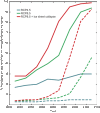
Fig. 5. The projected percentage of Roi inundated because of SLR and flooded annually because of the combined effects of waves and SLR through time for different SLR and climatic scenarios.
Dashed lines denote percentage of the island inundated by SLR, and the solid lines denote that annually flooded by waves. Large portions of the island are only affected by inundation due to SLR later in the 21st century, if at all, whereas significant portions are annually flooded by waves by the latter half of the 21st century for the RCP8.5 scenarios. Wave-driven flooding of more than 25% of the island, however, is enough to contaminate the groundwater and make it nonpotable, which is forecasted to be attained by the mid-21st century for the RCP8.5 scenarios and the latter half of the 21st century for the RCP4.5 scenario.

References

    1. Jevrejeva S., Grinsted A., Moore J. C., Anthropogenic forcing dominates sea-level rise since 1850. Geophys. Res. Lett. 36, L20706 (2009).
    1. Vermeer M., Rahmstorf S., Global sea level linked to global temperature. Proc. Natl. Acad. Sci. U.S.A. 106, 21527–21532 (2009). - PMC - PubMed
    1. Kopp R. E., Horton R. M., Little C. M., Mitrovica J. X., Oppenheimer M., Rasmussen D. J., Strauss B. H., Tebaldi C., Probabilistic 21st and 22nd century sea-level projections at a global network of tide-gauge sites. Earths Future 2, 383–406 (2014).
    1. J. A. Hall, S. Gill, J. Obeysekera, W. Sweet, K. Knuuti, J. Marburger, Regional Sea Level Scenarios for Coastal Risk Management: Managing the Uncertainty of Future Sea Level Change and Extreme Water Levels for Department of Defense Coastal Sites Worldwide (U.S. Department of Defense, Strategic Environmental Research and Development Program, 2016).
    1. Slangen A. B. A., Carson M., Katsman C. A., van de Wal R. S. W., Köhl A., Vermeersen L. L. A., Stammer D., Projecting twenty-first century regional sea-level changes. Clim. Change 124, 317–332 (2014).

Publication types

LinkOut - more resources