

Effects of Tree-crop Farming on Land-cover Transitions in a Mosaic Landscape in the Eastern Region of Ghana
- PMID: 29752495
- PMCID: PMC6132851
- DOI: 10.1007/s00267-018-1060-3
Effects of Tree-crop Farming on Land-cover Transitions in a Mosaic Landscape in the Eastern Region of Ghana
Abstract
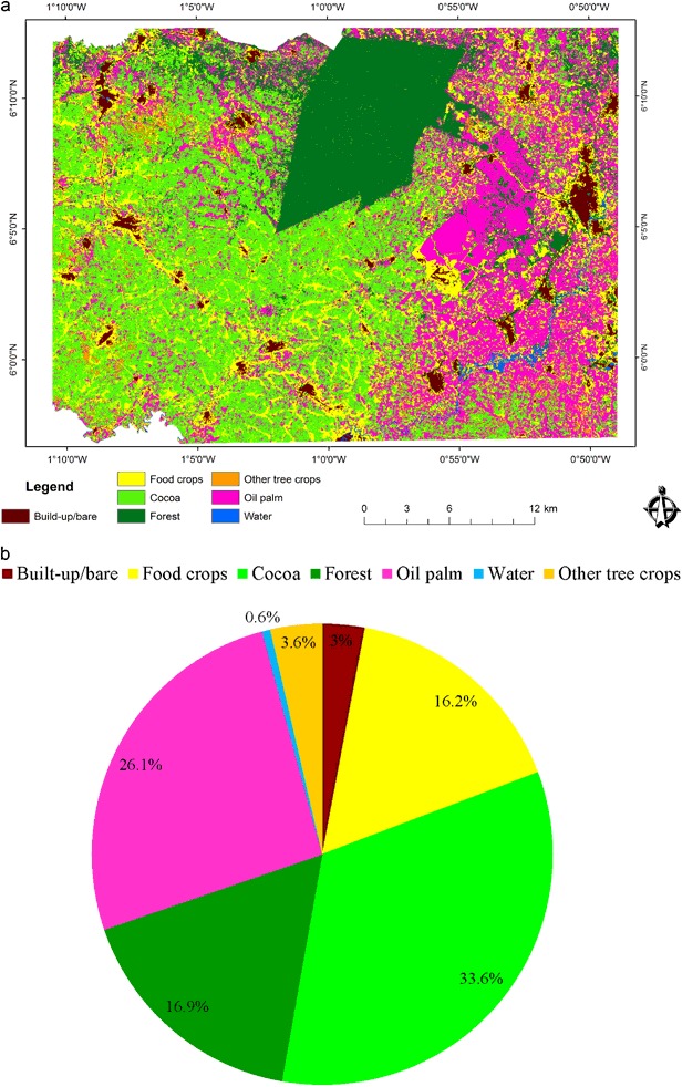
Tree crops such as cocoa and oil palm are important to smallholders' livelihoods and national economies of tropical producer countries. Governments seek to expand tree-crop acreages and improve yields. Existing literature has analyzed socioeconomic and environmental effects of tree-crop expansion, but its spatial effects on the landscape are yet to be explored. This study aims to assess the effects of tree-crop farming on the composition and the extent of land-cover transitions in a mixed cocoa/oil palm landscape in Ghana. Land-cover maps of 1986 and 2015 produced through ISODATA, and maximum likelihood classification were validated with field reference, Google Earth data, and key respondent interviews. Post-classification change detection was conducted and the transition matrix analyzed using intensity analysis. Cocoa and oil palm areas have increased in extent by 8.9% and 11.2%, respectively, mainly at the expense of food-crop land and forest. The intensity of forest loss to both tree crops is at a lower intensity than the loss of food-crop land. There were transitions between cocoa and oil palm, but the gains in oil palm outweigh those of cocoa. Cocoa and oil palm have increased in area and dominance. The main cover types converted to tree-crop areas are food-crop land and off-reserve forest. This is beginning to have serious implications for food security and livelihood options that depend on ecosystem services provided by the mosaic landscape. Tree-crop policies should take account of the geographical distribution of tree-commodity production at landscape level and its implications for food production and ecosystems services.
Keywords: Ghana; Tree crops; cocoa; intensity analysis; land-cover transitions; mosaic landscape; oil palm.
Conflict of interest statement
The authors declare that they have no conflict of interest.
Figures


References
-
- Abdullah SA, Nakagoshi N. Changes in landscape spatial pattern in the highly developing state of Selangor, peninsular Malaysia. Landsc Urban Plan. 2006;77:263–275. doi: 10.1016/j.landurbplan.2005.03.003. - DOI
-
- Adjei PO, Buor D, Addrah P. Geo-spatial analysis of land use and land cover changes in the Lake Bosomtwe Basin of Ghana. Ghana J Geogr. 2014;6:1–23.
-
- Ahmad A, Quegan S. Comparative analysis of supervised and unsupervised classification on multispectral data. Appl Math Sci. 2013;7:3681–3694.
-
- Akinyemi FO. An assessment of land-use change in the cocoa belt of south-west Nigeria. Int J Remote Sens. 2013;34:2858–2875. doi: 10.1080/01431161.2012.753167. - DOI
-
- Aldwaik SZ, Pontius RG. Intensity analysis to unify measurements of size and stationarity of land changes by interval, category, and transition. Landsc Urban Plan. 2012;106:103–114. doi: 10.1016/j.landurbplan.2012.02.010. - DOI
Publication types
MeSH terms
Substances
LinkOut - more resources
Full Text Sources
Other Literature Sources
