. 2018 Jul 16;8(1):10710.
doi: 10.1038/s41598-018-29105-2.

Growth of mountain belts in central Asia triggers a new collision zone in central India

Affiliations

Growth of mountain belts in central Asia triggers a new collision zone in central India

I Koulakov et al. Sci Rep. .

Abstract

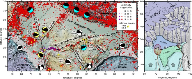
Several unusual strong earthquakes occurred in central India along the Narmada-Son Lineament (NSL) zone, far from active plate boundaries. To understand the role of collisional processes in the origin of this seismicity, we develop a numerical thermomechanical model of shortening between the Indian Plate and Asia. We show that at the final stage of collision, the shortening rate of the high mountain areas slows. The continuing convergence of India and Asia triggers the initiation of a new collision zone in continental part of India. Various geological and geophysical observations indicate that the NSL is a weakest zone with northward thrusting of the thinner central Indian lithosphere underneath the thicker northern part of the Indian Plate. We hypothesize that the NSL was reactivated during the final stage of the India Asia convergence and it will possibly form a new mountain belt within the Indian continent.


Conflict of interest statement

The authors declare no competing interests.

Figures

Figure 1
Figure 1
Structural elements in the study region and surroundings. (A) Seismicity distributions and major structural elements of the northern part of the Indian Plate. The background is the topography/bathymetry map extracted from Global Multi-Resolution Topography, GMRT. Red circles represent the seismicity from the merged regional (National Centre for Seismology, India) and ISC catalogues, whereas the dark violet circles represent the seismicity recorded by regional stations in the western part of the NSL. Major earthquakes are highlighted with yellow stars; if available, magnitudes and focal mechanisms are presented. Major fault zones, including the NSL, are shown. (B) Simplified representation of the “String-and-Block” concept for the description of the India-Asia collision. Blue “strings” represent the zones of thickened crust affected by gravitational spreading. Violet areas represent rigid lithosphere blocks. Light blue represents the incoming Indian Plate. The NSL divides India into two continental blocks: thicker northern (blue) and thinner southern (green) blocks. DT and RT represent the Deccan and Rajamahal traps, respectively; ellipses represent the zones of degraded lithosphere owing to the passage of the corresponding plumes. Red dotted lines represent the tracks of the Reunion and Kerguelen hot spots.
Figure 2
Figure 2
Anomalies of P-velocity derived from regional tomography inversion at 100 km depth representing the lithosphere structure. The line with arrows represents the NSL, and solid gray lines represent other major tectonic boundaries and faults in continental India. Ellipses represent the Deccan (DT) and Rajamahal (RT) traps. Red dotted lines represent the Reunion and Kerguelen hot spot tracks.
Figure 3
Figure 3
Results of numerical modeling of subsequent mountain building owing to shortening during the collision between India and stable Asia. The evolution of the topography and viscosity distributions in the uppermost mantle during four episodes of collision is shown. S.IN and N.IN indicate the southern and northern parts of the Indian continent, respectively.

References

    1. Kumar MR, Bhatia SC. A new seismic hazard map for the Indian plate region under the global seismic hazard assessment programme. Current Science. 1999;77:447–453.
    1. Raval U. Earthquakes over Kutch: a region of ‘trident’ space-time geodynamics. Curr. Sci. 2001;81:809–815.
    1. Kayal JR. Recent large earthquakes in India: seismotectonic perspective. IAGR Memoir. 2007;10:189–199.
    1. Acharyya SK. The nature of Mesoproterozoic Central Indian Tectonic Zone with exhumed and reworked older granulites. Gondwana Res. 2003;6:197–214. doi: 10.1016/S1342-937X(05)70970-9. - DOI
    1. Choubey VD. Narmada–Son Lineament, India. Nature Physical Science. 1971;232(28):38–40. doi: 10.1038/physci232038a0. - DOI

LinkOut - more resources