. 2019 Jun;48(6):649-660.
doi: 10.1007/s13280-018-1095-y. Epub 2018 Sep 4.

Local land use associated with socio-economic development in six arctic regions

Affiliations

Local land use associated with socio-economic development in six arctic regions

Dorothee Ehrich et al. Ambio. 2019 Jun.

Abstract

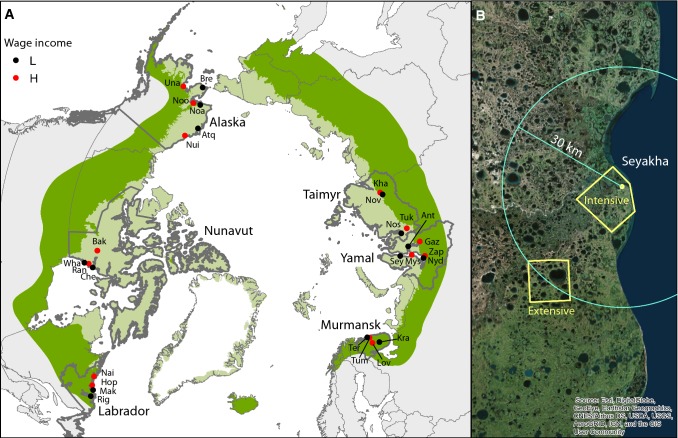
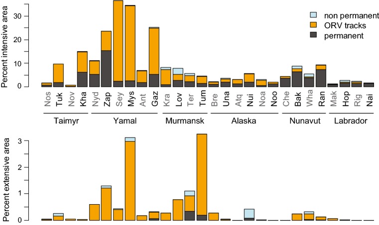
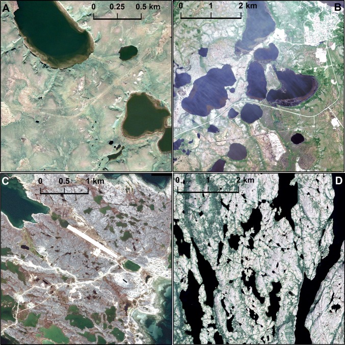
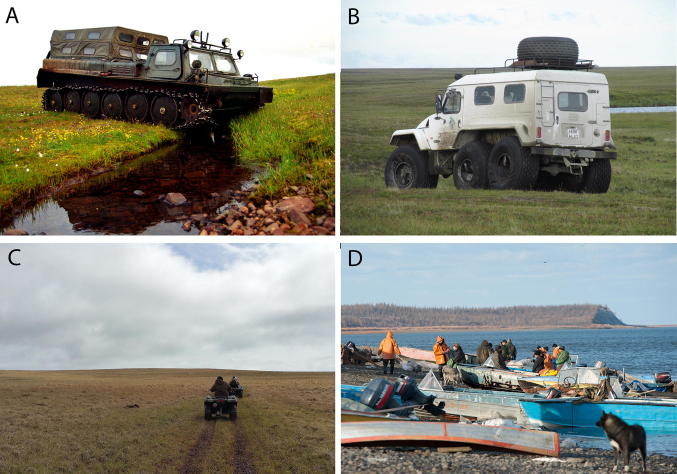
The socioeconomic causes of land use change are complex. They are highly context dependent, but most often studied through case studies. Here, we use a quasi-experimental paired block design to investigate whether better access to wage income leads to more visible land use around 28 settlements in six regions of the circumpolar Arctic. We mapped visible land use on high-resolution satellite images taken both close to the settlements, and in a more remote area of extensive land use, and payed special attention to tracks of off-road vehicles (ORV). Despite considerable differences among regions, there was an overall positive relationship between better access to wage income and land use. Reindeer herding was also associated with more visible use, in particular ORV tracks. These results suggest that access to wage income in the mixed subsistence-cash communities of the Arctic could lead to more local use related to harvesting and reindeer herding.

Keywords: Arctic tundra; Motorized vehicles; Remote sensing; Resource use; Socio-ecological systems; Subsistence.


Figures

Fig. 1
Fig. 1
Study design. a Regions and selected settlements. Study regions, including Murmanskaya Oblast’ (Murmansk), Yamalo-Nenetsky Autonomous Okrug (Yamal) and the northernmost part of Krasnoyarskiy Kray (Taimyr) are surrounded by thick grey lines. Three letter codes indicate settlement name (see Table 1). Wage income: L = settlements with lower access to wage income, H = settlements with higher access to wage income. Pale green shows the Arctic according to the Circumpolar Arctic Vegetation Map (Walker et al. 2005) and darker green shows the sub-arctic. b Example of the selection of areas for satellite pictures of an intensive use area and an extensive use area
Fig. 2
Fig. 2
Percent land area occupied by visible land use on each image. The upper panel shows intensive use area images, which included the settlement itself. The lower panel shows extensive use area images situated 30 km from the settlement. Note the different scales. Visible traces are shown according to the categories permanently transformed habitat, ORV tracks, and other non-permanent land cover transformation. Full names of the settlements are given in Table 1
Fig. 3
Fig. 3
Examples of satellite pictures. a The extensive use area of Mys Kamennyi was characterized by a high amount of ORV tracks. The high amount of tracks observed in extensive areas on Yamal Peninsula can be related both to reindeer herding and to the fact that the region is at present experiencing the second wave of development related to oil-and-gas exploitation. b Intensive use area image from Zapolyarnyi, the only area in Russia where permanent structures were more extensive than ORV tracks. Many of the structures on the present image are likely to be related to the gas industry. c Settlement area of Chesterfield Inlet, a settlement with a population of 313 in Nunavut, Canada, classified as lower access to wage income. Permanent structures such as buildings and roads were more important than ORV tracks in Canada. d No visible traces of human use were recorded in the extensive use area of Hopedale in Labrador (Canada). In this area, boats and snow scooter are main means of transportation, and the stony ground is less prone to show visible traces of use
Fig. 4
Fig. 4
Large size Russian off-road cars leave easily visible and persistent tracks, sometimes already after a single passage over a stretch of tundra, whereas intense land use based on boat or snow scooter traffic, which are cheaper means of transportation used a lot in the poorer Russian settlements and in North America, do not leave visible tracks at all. a Heavy chain vehicles were used in the Russian Arctic in the past, which left deep and long-lasting traces in tundra areas on soft ground, here wet areas (photo V. Belov). b Also many modern Russian ORV, such as this off-road car in Yamal, are of considerable size and thus prone to leave tracks which can be identified on satellite imagery pictures (photo I. Fufachev). c In Alaska and Canada people typically use smaller and lighter ORVs (photo J. Schmidt). d Intense fishing based on boat traffic does not leave visible land use traces in Novaya, Taimyr (photo A. Khrushev)

References

    1. Avango D, Hacquebord L, Wrakberg U. Industrial extraction of Arctic natural resources since the sixteenth century: Technoscience and geo-economics in the history of northern whaling and mining. Journal of Historical Geography. 2014;44:15–30. doi: 10.1016/j.jhg.2014.01.001. - DOI
    1. Behe C. Subsistence fishing in the Yukon River Delta: A case study of Alakanuk subsistence fishery and the use of local/traditional ecological knowledge. La Jolla: University of California San Diego; 2011.
    1. Bennett MM. Discursive, material, vertical, and extensive dimensions of post-Cold War Arctic resource extraction. Polar Geography. 2016;39:258–273. doi: 10.1080/1088937X.2016.1234517. - DOI
    1. Brinkman T, Maracle KB, Kelly J, Vandyke M, Firmin A, Springsteen A. Impact of fuel costs on high-latitude subsistence activities. Ecology and Society. 2014;19:9. doi: 10.5751/ES-06861-190418. - DOI
    1. Buixadé Farré A, Stephenson SR, Chen L, Czub M, Dai Y, Demchev D, Efimov Y, Graczyk P, et al. Commercial Arctic shipping through the Northeast Passage: Routes, resources, governance, technology, and infrastructure. Polar Geography. 2014;37:298–324. doi: 10.1080/1088937X.2014.965769. - DOI

LinkOut - more resources