The Future of Earth Observation in Hydrology
- PMID: 30233123
- PMCID: PMC6140349
- DOI: 10.5194/hess-21-3879-2017
The Future of Earth Observation in Hydrology
Abstract
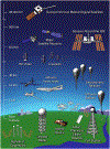
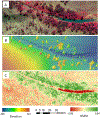
In just the past five years, the field of Earth observation has progressed beyond the offerings of conventional space agency based platforms to include a plethora of sensing opportunities afforded by CubeSats, Unmanned Aerial Vehicles (UAVs), and smartphone technologies that are being embraced by both for-profit companies and individual researchers. Over the previous decades, space agency efforts have brought forth well-known and immensely useful satellites such as the Landsat series and the Gravity Research and Climate Experiment (GRACE) system, with costs typically on the order of one billion dollars per satellite and with concept-to-launch timelines on the order of two decades (for new missions). More recently, the proliferation of smartphones has helped to miniaturise sensors and energy requirements, facilitating advances in the use of CubeSats that can be launched by the dozens, while providing ultra-high (3-5 m) resolution sensing of the Earth on a daily basis. Start-up companies that did not exist five years ago now operate more satellites in orbit than any space agency, and at costs that are a mere fraction of the cost of traditional satellite missions. With these advances come new space-borne measurements, such as real-time high-definition video for tracking air pollution, storm-cell development, flood propagation, precipitation monitoring, or even for constructing digital surfaces using structure-from-motion techniques. Closer to the surface, measurements from small unmanned drones and tethered balloons have mapped snow depths, floods, and estimated evaporation at sub-meter resolutions, pushing back on spatio-temporal constraints and delivering new process insights. At ground level, precipitation has been measured using signal attenuation between antennae mounted on cell phone towers, while the proliferation of mobile devices has enabled citizen-scientists to catalogue photos of environmental conditions, estimate daily average temperatures from battery state, and sense other hydrologically important variables such as channel depths using commercially available wireless devices. Global internet access is being pursued via high altitude balloons, solar planes, and hundreds of planned satellite launches, providing a means to exploit the Internet of Things as an entirely new measurement domain. Such global access will enable real-time collection of data from billions of smartphones or from remote research platforms. This future will produce petabytes of data that can only be accessed via cloud storage and will require new analytical approaches to interpret. The extent to which today's hydrologic models can usefully ingest such massive data volumes is unclear. Nor is it clear whether this deluge of data will be usefully exploited, either because the measurements are superfluous, inconsistent, not accurate enough, or simply because we lack the capacity to process and analyse them. What is apparent is that the tools and techniques afforded by this array of novel and game-changing sensing platforms present our community with a unique opportunity to develop new insights that advance fundamental aspects of the hydrological sciences. To accomplish this will require more than just an application of the technology: in some cases, it will demand a radical rethink on how we utilise and exploit these new observing systems to enhance our understanding of the Earth and its linked processes.
Figures


References
-
- Aires F, Prigent C, Rossow WB, and Rothstein M: A new neural network approach including first guess for retrieval of atmospheric water vapor, cloud liquid water path, surface temperature, and emissivities over land from satellite microwave observations, Journal of Geophysical Research Atmospheres, 106, 14887–14907, 2001.
-
- Aker JC, and Mbiti IM: Mobile phones and economic development in Africa, Journal of Economic Perspectives, 24, 207–232, 10.1257/jep.24.3.207, 2010. - DOI
-
- Alemohammad SH, Fang B, Konings AG, Green JK, Kolassa J, Prigent C, Aires F, Miralles D, and Gentine P: Water, Energy, and Carbon with Artificial Neural Networks (WECANN): A statistically-based estimate of global surface turbulent fluxes using solar-induced fluorescence, Biogeosciences Discuss, 2016, 1–36, 10.5194/bg-2016-495, 2016. - DOI - PMC - PubMed
-
- Allamano P, Croci A, and Laio F: Toward the camera rain gauge, Water Resources Research, 51, 1744–1757, 10.1002/2014WR016298, 2015. - DOI
-
- Alsdorf DE, Rodríguez E, and Lettenmaier DP: Measuring surface water from space, Reviews of Geophysics, 45, n/a–n/a, 10.1029/2006RG000197, 2007. - DOI
Grants and funding
LinkOut - more resources
Full Text Sources
Other Literature Sources
Miscellaneous
