

A voluntary conservation agreement reduces the risks of lethal collisions between ships and whales in the St. Lawrence Estuary (Québec, Canada): From co-construction to monitoring compliance and assessing effectiveness
- PMID: 30240393
- PMCID: PMC6150506
- DOI: 10.1371/journal.pone.0202560
A voluntary conservation agreement reduces the risks of lethal collisions between ships and whales in the St. Lawrence Estuary (Québec, Canada): From co-construction to monitoring compliance and assessing effectiveness
Abstract
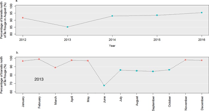
Lethal collisions with ships are limiting the recovery of several at-risk whale species worldwide. In the St. Lawrence Estuary (Quebec, Canada), the endangered blue whale and of special concern fin whale are among the migratory species subject to collisions with large ships. In 2011, a working group composed of representatives from the maritime industry, the government, non-governmental organizations, and academia was created to explore solutions to mitigate ship-whale collisions in the St. Lawrence Estuary. Adopting an adaptive risk management framework, the working group took advantage of the best available scientific data and tools to co-construct realistic collision mitigation options and evaluate their likely benefits for whale conservation and costs for the industry. In 2013, the working group recommended the implementation of voluntary measures to mitigate collision risks, consisting of a slow-down area, a no-go area, and a caution area; a recommended route was added in 2014. Along with the voluntary framework, the working group agreed to continuously monitor compliance with and assess effectiveness of these mitigation measures. After the fourth year of implementation, voluntary measures showed encouraging results, with a reduction of up to 40% of lethal collision risks with fin whales in the highest density area. This reduction in risk is mainly related to ship speed reduction in the slow-down area from 14.1 ± 2.6 knots in 2012 to 11.3 ± 1.7 knots since 2014. The presence of a mandatory pilotage area overlapping with the slow-down area was instrumental to facilitate communication about the mitigation measures, with the pilotage corporation sitting as a regular member of the working group. This resulted in significantly slower speeds in the slow-down area for ships with a pilot from the pilotage corporation onboard compared to those without (-0.8 knots, p-value < 0.001). It is also likely to explain the weaker compliance of the maritime industry with the no-go area located outside of the mandatory pilotage area. Other factors of success include: the continuous dedication of the government to a voluntary and transparent participatory process; the use of available data, tools and institutions; the presence of an environmental certification program representative in the working group; and the adoption by consensus of an adaptive risk management approach. The traditional regulatory approach to conservation is often blamed for its focus on deterring negative behaviors, doing nothing to encourage and reward positive ones. In agreement with other case studies, the benefits of the voluntary measures implemented in the St. Lawrence Estuary include the pro-active commitment from the industry (which is likely to reduce conflicts with regulators), the greater flexibility and freedom that allowed to come up with cost-effective and tailored-made mitigation measures, and the fast achievement of conservation gains. More importantly perhaps, the human and working capital built throughout the concertation process have the potential to be a fundamental cornerstone in dealing with more complex issues such as the chronically increasing level of underwater noise in whale habitats.
Conflict of interest statement
The authors have declared that no competing interests exist.
Figures


References
-
- Laist DW, Knowlton AR, Mead JG, Collet AS, Podesta M. Collisions Between Ships and Whales. Mar Mammal Sci. 2001;17: 35–75. 10.1111/j.1748-7692.2001.tb00980.x - DOI
-
- Richardson WJ, Greene CR, Malme CI, Thomson DH. Marine Mammals and Noise Academic Press. San Diego; 1995.
-
- Couvat J, Gambaiani D. Evaluation of the technical solutions and management measures implemented at the international level to reduce the risks of collisions between ships and large cetaceans Souffleurs d’Écume; 2013. p. 106.
-
- Parrott L, Chion C, Turgeon S, Ménard N, Cantin G, Michaud R. Slow Down and Save the Whales. Solut J. 2016;6: 40–47.
-
- Silber GK, Vanderlaan ASM, Tejedor Arceredillo A, Johnson L, Taggart CT, Brown MW, et al. The role of the International Maritime Organization in reducing vessel threat to whales: Process, options, action and effectiveness. Mar Policy. 2012;36: 1221–1233. 10.1016/j.marpol.2012.03.008 - DOI
Publication types
MeSH terms
LinkOut - more resources
Full Text Sources
Other Literature Sources
