

Wildfires and the role of their drivers are changing over time in a large rural area of west-central Spain
- PMID: 30542114
- PMCID: PMC6290888
- DOI: 10.1038/s41598-018-36134-4
Wildfires and the role of their drivers are changing over time in a large rural area of west-central Spain
Abstract
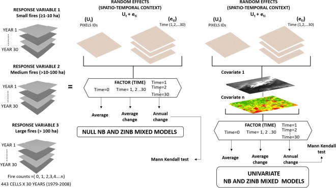
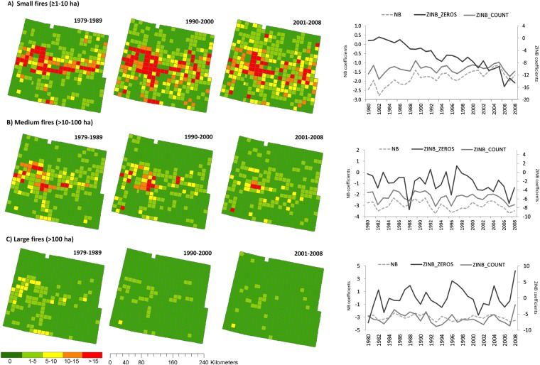
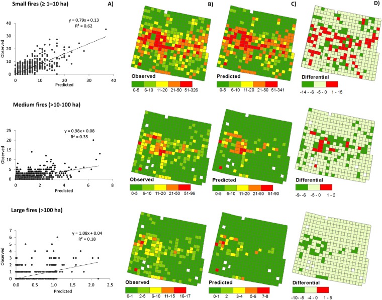
During the last decades, wildfires have been changing in many areas across the world, due to changes in climate, landscapes and socioeconomic drivers. However, how the role of these drivers changed over time has been little explored. Here, we assessed, in a spatially and temporally explicit way, the changing role of biophysical and human-related factors on wildfires in a rural area in west-central Spain from 1979 to 2008. Longitudinal Negative Binomial (NB) and Zero-Inflated Negative Binomial (ZINB) mixed models, with time as interacting factor (continuous and categorical), were used to model the number of fires of increasing size (≥1-10 ha, >10-100 ha, >100 ha) per 10 × 10 km cell per year, based on fire statistics. We found that the landscape was rather dynamic, and generally became more hazardous over time. Small fires increased and spread over the landscape with time, with medium and large fires being stable or decreasing. NB models were best for modelling small fires, while ZINB for medium and large; models including time as a categorical factor performed the best. Best models were associated to topography, land-use/land cover (LULC) types and the changes they underwent, as well as agrarian characteristics. Climate variables, forest interfaces, and other socioeconomic variables played a minor role. Wildfires were initially more frequent in rugged topography, conifer forests, shrublands and cells undergoing changes in LULC types of hazardous nature, for all fire sizes. As time went by, wildfires lost the links with the initial fire-prone areas, and as they spread, became more associated to lower elevation areas, with higher solar radiation, herbaceous crops, and large size farms. Thus, the role of the fire drivers changed over time; some decreased their explaining power, while others increased. These changes with time in the total number of fires, in their spatial pattern and in the controlling drivers limit the ability to predict future fires.
Conflict of interest statement
The authors declare no competing interests.
Figures


Similar articles
-
Increased burned area in the Pantanal over the past two decades.Sci Total Environ. 2022 Aug 20;835:155386. doi: 10.1016/j.scitotenv.2022.155386. Epub 2022 Apr 21. Sci Total Environ. 2022. PMID: 35461933
-
Small forest patches and landscape-scale fragmentation exacerbate forest fire prevalence in Amazonia.J Environ Manage. 2025 Feb;375:124312. doi: 10.1016/j.jenvman.2025.124312. Epub 2025 Jan 25. J Environ Manage. 2025. PMID: 39862833
-
Fuel treatment effectiveness in the context of landform, vegetation, and large, wind-driven wildfires.Ecol Appl. 2020 Jul;30(5):e02104. doi: 10.1002/eap.2104. Epub 2020 Apr 2. Ecol Appl. 2020. PMID: 32086976
-
Landscape--wildfire interactions in southern Europe: implications for landscape management.J Environ Manage. 2011 Oct;92(10):2389-402. doi: 10.1016/j.jenvman.2011.06.028. Epub 2011 Jul 8. J Environ Manage. 2011. PMID: 21741757 Review.
-
How do forest fires affect soil greenhouse gas emissions in upland boreal forests? A review.Environ Res. 2020 May;184:109328. doi: 10.1016/j.envres.2020.109328. Epub 2020 Mar 5. Environ Res. 2020. PMID: 32163772 Review.
Cited by
-
The submerged footprint of Perito Moreno glacier.Sci Rep. 2020 Oct 2;10(1):16437. doi: 10.1038/s41598-020-73410-8. Sci Rep. 2020. PMID: 33009481 Free PMC article.
-
Modelling fire hazard in the southern Mediterranean fire rim (Bejaia region, northern Algeria).Environ Monit Assess. 2019 Nov 13;191(12):747. doi: 10.1007/s10661-019-7931-0. Environ Monit Assess. 2019. PMID: 31724084
References
-
- Urbieta IR, et al. Fire activity as a function of fire–weather seasonal severity and antecedent climate across spatial scales in southern Europe and Pacific western USA. Environ Res Lett. 2015;10:114013. doi: 10.1088/1748-9326/10/11/114013. - DOI
-
- Rodrigues M, San Miguel J, Oliveira S, Moreira F, Camia A. An insight into spatial-temporal trends of fire ignitions and burned areas in the European Mediterranean countries. Journal of Earth Science and Engineering. 2013;3:497.
Publication types
LinkOut - more resources
Full Text Sources
Research Materials
