

Heterogeneous retreat and ice melt of Thwaites Glacier, West Antarctica
- PMID: 30729155
- PMCID: PMC6353628
- DOI: 10.1126/sciadv.aau3433
Heterogeneous retreat and ice melt of Thwaites Glacier, West Antarctica
Abstract
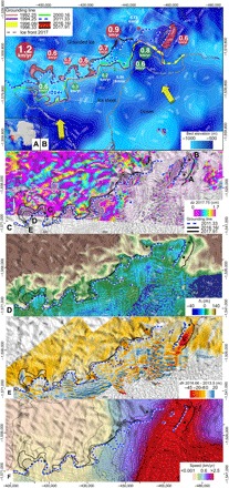
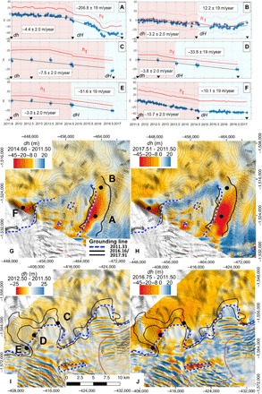
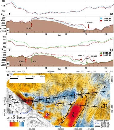
The glaciers flowing into the Amundsen Sea Embayment, West Antarctica, have undergone acceleration and grounding line retreat over the past few decades that may yield an irreversible mass loss. Using a constellation of satellites, we detect the evolution of ice velocity, ice thinning, and grounding line retreat of Thwaites Glacier from 1992 to 2017. The results reveal a complex pattern of retreat and ice melt, with sectors retreating at 0.8 km/year and floating ice melting at 200 m/year, while others retreat at 0.3 km/year with ice melting 10 times slower. We interpret the results in terms of buoyancy/slope-driven seawater intrusion along preferential channels at tidal frequencies leading to more efficient melt in newly formed cavities. Such complexities in ice-ocean interaction are not currently represented in coupled ice sheet/ocean models.
Figures
References
-
- Church J. A., White N. J., Konikow L. F., Domingues C. M., Cogley J. G., Rignot E., Gregory J. M., van den Broeke M. R., Monaghan A. J., Velicogna I., Revisiting the Earth’s sea-level and energy budgets from 1961 to 2008. Geophys. Res. Lett. 38 (2011).
-
- Alley R. B., Anandakrishnan S., Christianson K., Horgan H. J., Muto A., Parizek B. R., Pollard D., Walker R. T., Oceanic forcing of ice-sheet retreat: West Antarctica and more. Annu. Rev. Earth Planet. Sci. 43, 207–231 (2015).
-
- Joughin I., Smith B. E., Medley B. M., Marine ice sheet collapse potentially under way for the Thwaites Glacier Basin, West Antarctica. Science 344, 735–738 (2014). - PubMed
-
- Rignot E., Mouginot J., Morlighem M., Seroussi H., Scheuchl B., Widespread, rapid grounding line retreat of Pine Island, Thwaites, Smith, and Kohler glaciers, West Antarctica, from 1992 to 2011. Geophys. Res. Lett. 41, 3502–3509 (2014).
-
- DeConto R. M., Pollard D., Contribution of Antarctica to past and future sea-level rise. Nature, 531, 591–597 (2016). - PubMed
LinkOut - more resources
Full Text Sources
Miscellaneous
