Review
. 2019 Jun;25(6):1905-1921.
doi: 10.1111/gcb.14591. Epub 2019 Apr 1.

Spatial early warning signals for impending regime shifts: A practical framework for application in real-world landscapes

Affiliations
Review

Spatial early warning signals for impending regime shifts: A practical framework for application in real-world landscapes

Jelmer J Nijp et al. Glob Chang Biol. 2019 Jun.

Abstract

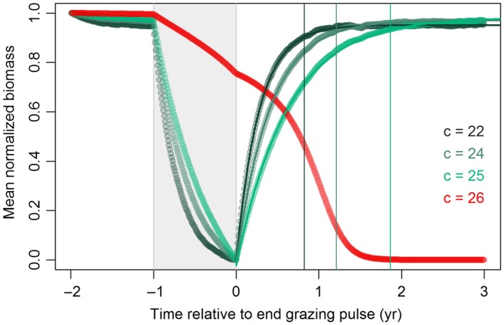
Prediction of ecosystem response to global environmental change is a pressing scientific challenge of major societal relevance. Many ecosystems display nonlinear responses to environmental change, and may even undergo practically irreversible 'regime shifts' that initiate ecosystem collapse. Recently, early warning signals based on spatiotemporal metrics have been proposed for the identification of impending regime shifts. The rapidly increasing availability of remotely sensed data provides excellent opportunities to apply such model-based spatial early warning signals in the real world, to assess ecosystem resilience and identify impending regime shifts induced by global change. Such information would allow land-managers and policy makers to interfere and avoid catastrophic shifts, but also to induce regime shifts that move ecosystems to a desired state. Here, we show that the application of spatial early warning signals in real-world landscapes presents unique and unexpected challenges, and may result in misleading conclusions when employed without careful consideration of the spatial data and processes at hand. We identify key practical and theoretical issues and provide guidelines for applying spatial early warning signals in heterogeneous, real-world landscapes based on literature review and examples from real-world data. Major identified issues include (1) spatial heterogeneity in real-world landscapes may enhance reversibility of regime shifts and boost landscape-level resilience to environmental change (2) ecosystem states are often difficult to define, while these definitions have great impact on spatial early warning signals and (3) spatial environmental variability and socio-economic factors may affect spatial patterns, spatial early warning signals and associated regime shift predictions. We propose a novel framework, shifting from an ecosystem perspective towards a landscape approach. The framework can be used to identify conditions under which resilience assessment with spatial remotely sensed data may be successful, to support well-informed application of spatial early warning signals, and to improve predictions of ecosystem responses to global environmental change.

Keywords: alternative stable states; critical slowing down; early warning signals; ecosystem resilience; environmental change; landscapes; regime shifts; remote sensing; spatial patterns; tipping points.


Figures

Figure 1
Figure 1
Prerequisites for application of spatial early warning signals to infer impending regime shifts in real‐world applications. The framework indicates main problems, their cause and effect on spatial early warning signals and regime shift prediction, and options to solve these problems. The numbered prerequisites refer to section numbers. Prerequisites with thin‐lined boxes are based on published conceptual reviews on early warning performance. Roman numerals refer to: (I) Boettiger et al. (2013), (II) Mander et al. (2017), (III) Dakos et al. (2015) and (IV) Dakos et al. (2011). The framework is not necessarily hierarchical [Colour figure can be viewed at http://wileyonlinelibrary.com]
Figure B1
Figure B1
(a) Two alternative regimes of biomass as function of increasing and decreasing grazing pressure. The black curved lines represent stable (solid) and unstable (dashed) equilibria, the black dots indicate tipping points. Greek symbols and vertical lines indicate specific (increasing) grazing levels for which spatial snapshots are shown (α‐δ). The snapshots show deviations from mean biomass in the snapshot as variation in biomass was much larger between snapshots than within. (b–e) Metrics that are suggested to provide spatial early warning signals for regime shifts (following Kéfi et al., 2014). SDR is the spectral density ratio, defined as the ratio of spectral ‘power’ in the lowest (0%–20%) to highest (80%–100%) portion of spectral frequencies [Colour figure can be viewed at http://wileyonlinelibrary.com]
Figure B2
Figure B2
Biomass recovery after pulse events of increased grazing pressure slows down with lower resilience. A pulse of increased grazing pressure (Δc = +1.0, duration = 1 year) was employed at different grazing levels to simulate recovery from perturbations. Biomass (B) was range‐normalized B't=i=Bt=i-Bmin/(Bmin-Bmax) to ease comparison of recovery from perturbations at different grazing pressures. Recovery time was estimated from a saturated exponential function: (t)=p1(1-exp(-t/p2))+p3, where B′ is the range‐normalized biomass, t is time, and p 1, p 2 and p 3 are fitting parameters. Recovery time (vertical coloured lines) was defined as 95% of the asymptotic value, that is, 3·p 2 conform Webster and Oliver (2007). All fits were significant (p « 0.01) and in good agreement with model‐generated data (Willmott's index of agreement > 0.99; Willmott et al., 1985) [Colour figure can be viewed at http://wileyonlinelibrary.com]
Figure 2
Figure 2
Examples of externally imposed drivers for spatial vegetation patterns. (a) Effect of soil variability on vegetation distribution in the Serengeti‐Mara savannah system (1°47′S 34°33′E). A vegetation map (green = forest, white = grass) is superimposed on a soil map (orange = clayey soils of valley bottoms and riverbeds, red = loamy soils of hills and steep slopes in uplands). The vegetation map is derived from Reed et al. (2008) and classified in forest and grass following Eby et al. (2017); the soil map is modified after de Wit (1978). (b) Semi‐arid woodland in southern Sudan (11°24′N 28°0′E) showing reduced vegetation presence around scattered homesteads (arrows) (c–e) illustrating anthropogenic impact on vegetation patterns (Imagery source: 2 February 2014, Google Earth, DigitalGlobe, 2018) [Colour figure can be viewed at http://wileyonlinelibrary.com]
Figure 3
Figure 3
Modelled effects of landscape heterogeneity on vegetation recovery from changing environmental drivers and regime shift characteristics (a) A hydrologically connected landscape with rolling hills. The landscape extent is 1 km2 and cell size is 25 m2. Total relief is 16 m. (b) Simulated banded vegetation pattern under semi‐arid conditions (320 mm/year, see Fig. d). Vegetation density ranges from 64 to 0 g/m2. (c) Persistence of vegetation under arid conditions (75 mm/year, see Fig. d) in positions that receive run‐on water flow. Vegetation density ranges from 64 to 0 g/m2. (d) Landscape‐averaged response and recovery curves indicating extremely limited hysteresis and very gradual response for the rolling hills landscape. The grey line shows a reference result for a straight slope landscape, with sudden recovery at rainfall 225 mm/year, leading to substantial hysteresis. Arrows indicate directions of ecosystem response trajectories to rainfall [Colour figure can be viewed at http://wileyonlinelibrary.com]
Figure 4
Figure 4
Dependence of spatial early warning signals on mean field value persists with coarse‐graining. The top row illustrates the effect of coarse‐graining (increasing with columns a to e) on spatial patterns of grassland (bright colours) and forest (dark colours) in a representative spatial snapshot (7.5 × 7.5 km) of the Serengeti‐Mara ecosystem. CG denotes the coarse‐graining factor and dx the grid resolution, red or black borders indicate bimodal or unimodal distribution of grass cover. The middle and bottom row show suggested SEWS spatial variance and skewness as a function of mean grass cover and how they depend on coarse‐graining pre‐processing. Snapshot data are taken along a rainfall gradient. Numbers in top‐right of each graph indicate the goodness of fit (R 2 adj) of the theoretical mean versus variance or skewness relationships, which were all significant (p < 0.05). Grey areas correspond to 95% confidence intervals of early warning signals acquired from 200 simulated null‐models (through random permutation snapshot grid cells conform Kéfi et al., 2014) [Colour figure can be viewed at http://wileyonlinelibrary.com]
Figure 5
Figure 5
Effect of alternative stable state definitions on spatial early warning signals (a) Vegetation pattern of semi‐arid woodland in the Sahel region in Sudan (11°7′N 28°15E, image source: 11 September 2014, Google Earth © 2018, Digital Globe 2018) showing three distinct colours that are associated with vegetated (green), bare (white) and ‘herbaceous plants’ (brown‐red) cover. (b) Classified vegetation map with three land cover types. (c) Classified vegetation map where the red land cover type is merged with the ‘vegetated’ state or (d) with the bare soil state. Early warning signals (numbers below figures) are calculated for the forested state [Colour figure can be viewed at http://wileyonlinelibrary.com]
Figure 6
Figure 6
Variogram analyses as prospective spatial early warning signal. (a) Definition of variogram parameters that characterize spatial heterogeneity. The x‐axis represents the separation distance between points in space, the y‐axis the mean variance at this separation distance averaged over multiple point‐pairs (referred to as semivariance). Typically, the similarity decreases with increasing separation distance, increasing the semivariance. The correlation range represents the separation distance up to which points in space are correlated, and can be interpreted as a quantitative measure of mean patch size. The partial sill is the part of variance that is spatially structured, whereas the nugget effect represents a random component. Together they constitute the sill. A variogram consisting of only a nugget represent pure spatial random noise. (b) Vegetation biomass as function of grazing pressure. (c) Variability of biomass in space (sill; nugget + partial sill parameter). (d) Mean patch size (m) of biomass (correlation range parameter): represents the characteristic length scale at which spatial patterns emerge. (e) The relative structural variance (100% partial sill/(partial sill + nugget)), quantifying whether data are spatially structured (100%) or organized randomly (0%) [Colour figure can be viewed at http://wileyonlinelibrary.com]

Similar articles

Cited by

References

    1. Aleman, J. C. , Blarquez, O. , & Staver Carla, A. (2016). Land‐use change outweighs projected effects of changing rainfall on tree cover in sub‐Saharan Africa. Global Change Biology, 22(9), 3013–3025. 10.1111/gcb.13299 - DOI - PubMed
    1. Allen, M. R. , & Ingram, W. J. (2002). Constraints on future changes in climate and the hydrologic cycle. Nature, 419, 224–232. 10.1038/nature01092 - DOI - PubMed
    1. Baartman, J. E. , Temme, A. J. , & Saco, P. M. (2018). The effect of landform variation on vegetation patterning and related sediment dynamics. Earth Surface Processes and Landforms, 43, 2121–2135. 10.1002/esp.4377 - DOI
    1. Barbier, N. , Couteron, P. , Lejoly, J. , Deblauwe, V. , & Lejeune, O. (2006). Self‐organized vegetation patterning as a fingerprint of climate and human impact on semi‐arid ecosystems. Journal of Ecology, 94(3), 537–547.
    1. Berdugo, M. , Kéfi, S. , Soliveres, S. , & Maestre, F. T. (2017). Plant spatial patterns identify alternative ecosystem multifunctionality states in global drylands. Nature Ecology & Evolution, 1(2), 0003 10.1038/s41559-016-0003 - DOI - PubMed

Publication types

LinkOut - more resources