

Using deep learning to examine street view green and blue spaces and their associations with geriatric depression in Beijing, China
- PMID: 30797100
- PMCID: PMC6437315
- DOI: 10.1016/j.envint.2019.02.013
Using deep learning to examine street view green and blue spaces and their associations with geriatric depression in Beijing, China
Abstract
Background: Residential green and blue spaces may be therapeutic for the mental health. However, solid evidence on the linkage between exposure to green and blue spaces and mental health among the elderly in non-Western countries is scarce and limited to exposure metrics based on remote sensing images (i.e., land cover and vegetation indices). Such overhead-view measures may fail to capture how people perceive the environment on the site.
Objective: This study aimed to compare streetscape metrics derived from street view images with satellite-derived ones for the assessment of green and blue space; and to examine associations between exposure to green and blue spaces as well as geriatric depression in Beijing, China.
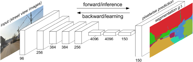
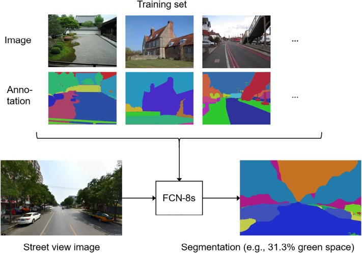
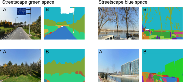
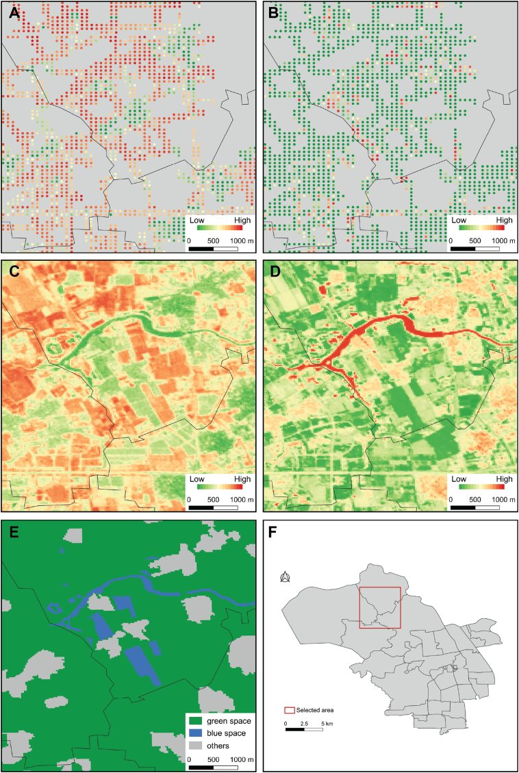
Methods: Questionnaire data on 1190 participants aged 60 or above were analyzed cross-sectionally. Depressive symptoms were assessed through the shortened Geriatric Depression Scale (GDS-15). Streetscape green and blue spaces were extracted from Tencent Street View data by a fully convolutional neural network. Indicators derived from street view images were compared with a satellite-based normalized difference vegetation index (NDVI), a normalized difference water index (NDWI), and those derived from GlobeLand30 land cover data on a neighborhood level. Multilevel regressions with neighborhood-level random effects were fitted to assess correlations between GDS-15 scores and these green and blue spaces exposure metrics.
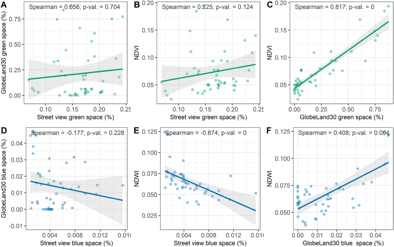
Results: The average cumulative GDS-15 score was 3.4 (i.e., no depressive symptoms). Metrics of green and blue space derived from street view images were not correlated with satellite-based ones. While NDVI was highly correlated with GlobeLand30 green space, NDWI was moderately correlated with GlobeLand30 blue space. Multilevel regressions showed that both street view green and blue spaces were inversely associated with GDS-15 scores and achieved the highest model goodness-of-fit. No significant associations were found with NDVI, NDWI, and GlobeLand30 green and blue space. Our results passed robustness tests.
Conclusion: Our findings provide support that street view green and blue spaces are protective against depression for the elderly in China, yet longitudinal confirmation to infer causality is necessary. Street view and satellite-derived green and blue space measures represent different aspects of natural environments. Both street view data and deep learning are valuable tools for automated environmental exposure assessments for health-related studies.
Keywords: China; Deep learning; Depression; Exposures; Natural environments; Street view data; The elderly.
Copyright © 2019 The Authors. Published by Elsevier Ltd.. All rights reserved.
Figures
Similar articles
-
Urban greenery and mental wellbeing in adults: Cross-sectional mediation analyses on multiple pathways across different greenery measures.Environ Res. 2019 Sep;176:108535. doi: 10.1016/j.envres.2019.108535. Epub 2019 Jun 21. Environ Res. 2019. PMID: 31260914
-
Using machine learning to examine street green space types at a high spatial resolution: Application in Los Angeles County on socioeconomic disparities in exposure.Sci Total Environ. 2021 Sep 15;787:147653. doi: 10.1016/j.scitotenv.2021.147653. Epub 2021 May 8. Sci Total Environ. 2021. PMID: 36118158 Free PMC article.
-
Green-blue space exposure changes and impact on individual-level well-being and mental health: a population-wide dynamic longitudinal panel study with linked survey data.Public Health Res (Southampt). 2023 Oct;11(10):1-176. doi: 10.3310/LQPT9410. Public Health Res (Southampt). 2023. PMID: 37929711
-
Spatial dimensions of the influence of urban green-blue spaces on human health: A systematic review.Environ Res. 2020 Jan;180:108869. doi: 10.1016/j.envres.2019.108869. Epub 2019 Nov 2. Environ Res. 2020. PMID: 31722804
-
Green spaces and mortality: a systematic review and meta-analysis of cohort studies.Lancet Planet Health. 2019 Nov;3(11):e469-e477. doi: 10.1016/S2542-5196(19)30215-3. Lancet Planet Health. 2019. PMID: 31777338 Free PMC article.
Cited by
-
Association between urban environment and mental health in Brussels, Belgium.BMC Public Health. 2021 Apr 1;21(1):635. doi: 10.1186/s12889-021-10557-7. BMC Public Health. 2021. PMID: 33794817 Free PMC article.
-
Relationship between urban green space and mental health in older adults: mediating role of relative deprivation, physical activity, and social trust.Front Public Health. 2024 Aug 29;12:1442560. doi: 10.3389/fpubh.2024.1442560. eCollection 2024. Front Public Health. 2024. PMID: 39267636 Free PMC article.
-
Associations of street-view greenspace with Parkinson's disease hospitalizations in an open cohort of elderly US Medicare beneficiaries.Environ Int. 2024 Jun;188:108739. doi: 10.1016/j.envint.2024.108739. Epub 2024 May 11. Environ Int. 2024. PMID: 38754245 Free PMC article.
-
Spatiotemporal variability of the association between greenspace exposure and depression in older adults in South Korea.BMC Public Health. 2024 Sep 19;24(1):2556. doi: 10.1186/s12889-024-19952-2. BMC Public Health. 2024. PMID: 39300384 Free PMC article.
-
Urban green space, perceived everyday discrimination and mental health among rural-to-urban migrants: a multilevel analysis in Wuhan, China.BMC Public Health. 2024 Oct 11;24(1):2788. doi: 10.1186/s12889-024-20269-3. BMC Public Health. 2024. PMID: 39394081 Free PMC article.
References
-
- Alcock I., White M.P., Lovell R., Higgins S.L., Osborne N.J., Husk K., Wheeler B.W. What accounts for ‘England's green and pleasant land’? A panel data analysis of mental health and land cover types in rural England. Landsc. Urban Plan. 2015;142:38–46.
-
- Arnberger A., Allex B., Eder R., Ebenberger M., Wanka A., Kolland F., Wallner P., Hutter H.-P. Elderly resident's uses of and preferences for urban green spaces during heat periods. Urban For. Urban Green. 2017;21:102–115.
-
- Arsanjani J. Springer; Heidelberg: 2015. OpenStreetMap in GIScience: Experiences, Research, Applications.
-
- Boers S., Hagoort K., Scheepers F., Helbich M. Does residential green and blue space promote recovery in psychotic disorders? A cross-sectional study in the province of Utrecht, the Netherlands. Int. J. Environ. Res. Public Health. 2018;15(10):2195. https://www.mdpi.com/1660-4601/15/10/2195. - PMC - PubMed
Publication types
MeSH terms
LinkOut - more resources
Full Text Sources
Medical
