

Geostatistical analysis and mapping of malaria risk in children under 5 using point-referenced prevalence data in Ghana
- PMID: 30871551
- PMCID: PMC6419518
- DOI: 10.1186/s12936-019-2709-y
Geostatistical analysis and mapping of malaria risk in children under 5 using point-referenced prevalence data in Ghana
Abstract
Background: Malaria remains a major challenge in sub-Saharan Africa and Ghana is not an exception. Effective malaria transmission control requires evidence-based targeting and utilization of resources. Disease risk mapping provides an effective and efficient tool for monitoring transmission and control efforts. The aim of this study is to analyse and map malaria risk in children under 5 years old, with the ultimate goal of identifying areas where control efforts can be targeted.
Methods: Data collected from the 2016 Ghana demographic and health survey was analyzed. Binomial logistic regression was applied to examine the determinants of malaria risk among children. Model-based geostatistical methods were applied to analyze, predict and map malaria prevalence.
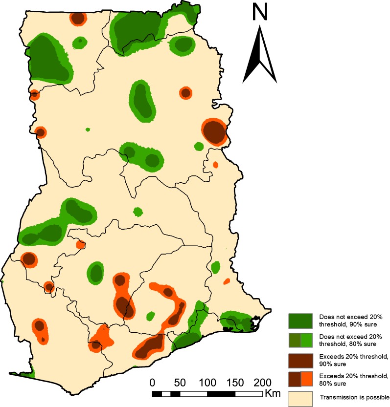
Results: There is a significant association of malaria prevalence with area of residence (rural/urban), age, indoor residual spray use, social economic status and mother's education level. Overall, parasitaemia prevalence among children under 5 years old for the year 2016 is low albeit characterized by "hotspots" in specific areas.
Conclusion: The risk maps indicate the spatial heterogeneity of malaria prevalence. The high resolution maps can serve as an effective tool in the identification of locations that require targeted interventions by programme implementers; this is key and relevant for reducing malaria burden in Ghana.
Keywords: Exceedance probability; Geostatistics; Hotspot; Malaria; Mapping.
Conflict of interest statement
The authors declare that they have no competing interests.
Figures


References
-
- World Health Organization. World malaria report 2017. Geneva: World Health Organization; 2017. https://www.who.int/malaria/publications/world-malaria-report-2017/en/. Accessed 1 Apr 2018.
-
- President’s Malaria Initiative. Malaria burden in Africa; 2018. http://www.africairs.net/the-malaria-burden-in-africa/. Accessed 1 Apr 2018.
-
- World Health Organization. World malaria report 2015. Geneva: World Health Organization; 2015. http://www.who.int/iris/handle/10665/200018. Accessed 1 Apr 2018.
-
- UNICEF. UNICEF Ghana fact sheet malaria; 2007. https://www.unicef.org/wcaro/WCARO_Ghana_Factsheet_malaria.pdf. Accessed 1 Apr 2018.
MeSH terms
Grants and funding
LinkOut - more resources
Full Text Sources
Medical
