. 2019 Apr;568(7750):55-60.
doi: 10.1038/s41586-019-1033-6. Epub 2019 Mar 19.

The unexpected surface of asteroid (101955) Bennu

Collaborators, Affiliations

The unexpected surface of asteroid (101955) Bennu

D S Lauretta et al. Nature. 2019 Apr.

Abstract

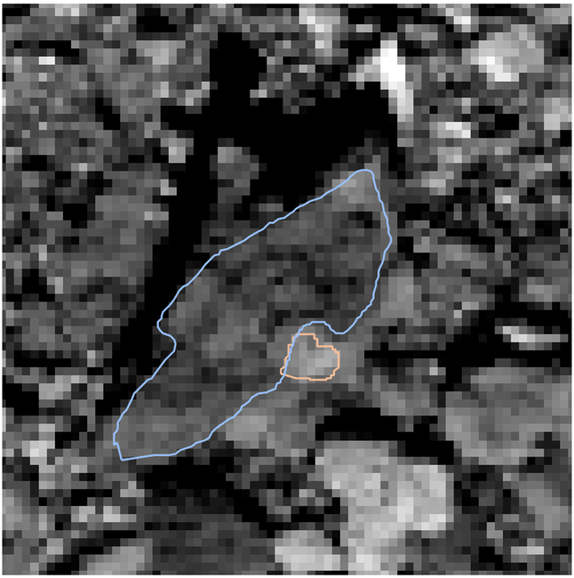
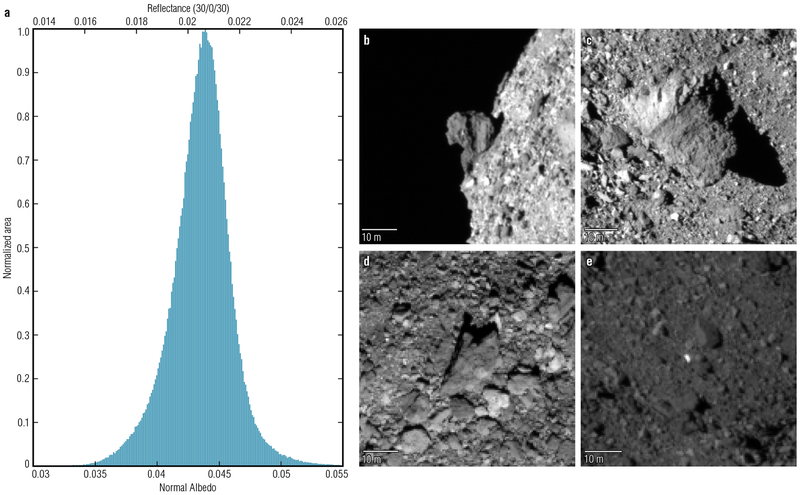
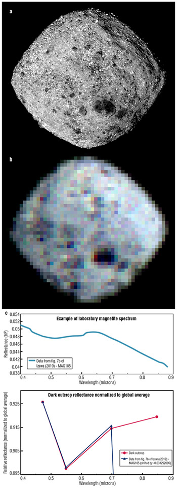
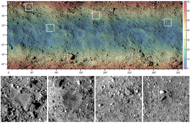
NASA'S Origins, Spectral Interpretation, Resource Identification and Security-Regolith Explorer (OSIRIS-REx) spacecraft recently arrived at the near-Earth asteroid (101955) Bennu, a primitive body that represents the objects that may have brought prebiotic molecules and volatiles such as water to Earth1. Bennu is a low-albedo B-type asteroid2 that has been linked to organic-rich hydrated carbonaceous chondrites3. Such meteorites are altered by ejection from their parent body and contaminated by atmospheric entry and terrestrial microbes. Therefore, the primary mission objective is to return a sample of Bennu to Earth that is pristine-that is, not affected by these processes4. The OSIRIS-REx spacecraft carries a sophisticated suite of instruments to characterize Bennu's global properties, support the selection of a sampling site and document that site at a sub-centimetre scale5-11. Here we consider early OSIRIS-REx observations of Bennu to understand how the asteroid's properties compare to pre-encounter expectations and to assess the prospects for sample return. The bulk composition of Bennu appears to be hydrated and volatile-rich, as expected. However, in contrast to pre-encounter modelling of Bennu's thermal inertia12 and radar polarization ratios13-which indicated a generally smooth surface covered by centimetre-scale particles-resolved imaging reveals an unexpected surficial diversity. The albedo, texture, particle size and roughness are beyond the spacecraft design specifications. On the basis of our pre-encounter knowledge, we developed a sampling strategy to target 50-metre-diameter patches of loose regolith with grain sizes smaller than two centimetres4. We observe only a small number of apparently hazard-free regions, of the order of 5 to 20 metres in extent, the sampling of which poses a substantial challenge to mission success.


Figures

Extended Data Figure 1.
The global mosaic of Bennu projected onto a sinusoidal map that preserves area. The PolyCam images were photometrically corrected to mimic imaging conditions with phase, emission, and incidence angles of 0°. The map has a pixel scale of 1.2 m/pixel. Images were taken on 25 November 2018.
Extended Data Figure 2.
Areas for calculation of albedo variation in Fig. 1d.
Extended Data Figure 3.
Timeline of the various observations made during the Approach Phase.
Extended Data Figure 4.
Extended Data Figure 4.. Schematic of Preliminary Survey showing three passes over the North Pole.
Each trajectory leg lasts two days. The observations consist of MapCam mosaics made far from Bennu, both on the inbound and outbound legs from closest approach, OLA observations made near closest approach, both inbound and outbound, and additional MapCam mosaics made soon after the OLA observations but on the outbound legs of the polar flybys only. The times of closest approach to the pole was set at a nominal 17:00 UTC for all flybys.
Figure 1.
Figure 1.. Range of albedo on the surface of Bennu.
a, Histogram describing the normal albedo distribution of Bennu’s surface based on low-phase-angle images acquired by the PolyCam imager [9] on 25 November 2018. The axis along the top of the plot gives values for the same data when corrected to standard laboratory conditions (30° phase, 0° emission, 30° incidence) to enable direct comparison to the meteorite record. b to e, PolyCam images acquired on 1 and 2 December 2018 highlight the range of albedo heterogeneity on Bennu. b, One of the darkest boulders (~3.3% normal albedo), perched on the surface of the asteroid (phase angle 51°, 0.32 m/pixel). c, A 30-m boulder that defines the prime meridian and has a near-average albedo of ~4% (phase angle 49°, 0.32 m/pixel). d, A boulder includes a clast that is 33% brighter than its host matrix (phase angle 33°, 0.43 m/pixel; see methods). e, The brightest object identified thus far on Bennu (phase angle 34°, 0.42 m/pixel).
Figure 2.
Figure 2.. OCAMS imaging data elucidate Bennu’s diverse surface reflectance and composition.
a, Image acquired by the PolyCam imager on 25 November 2018 at a phase angle of ~5° and a pixel scale of ~1.1 m/pixel. b, Color mosaic acquired by the MapCam imager [9] on 8 November 2018 at a phase angle of ~5° and a pixel scale of 10.9 m/pixel (coarse pixel scale is due to the wider field of view of the MapCam). c, The upper plot shows a full laboratory spectrum of magnetite [22]. The lower plot shows the laboratory magnetite spectrum in a manner comparable to the broadband spectrum from the 8 November MapCam data for the large dark outcrop on Bennu’s surface (evident in the lower center-right of panels a and b). Both spectra in the lower plot are normalized to the global average reflectance of Bennu. In combination with OTES data [15], the 0.55-μm absorption feature in the MapCam data indicates the presence of magnetite on Bennu.
Figure 3.
Figure 3.. OCAMS global mosaic overlain with elevation data and four regions of interest for sampling.
a, The surface of Bennu is covered by numerous boulders at the meter scale or larger. The color scale of the overlay shows elevation above the geopotential from 0 m (blue) to 70 m (red). Tick marks indicate latitude and longitude. The global mosaic consists of PolyCam images taken on 1 December 2018 and MapCam images taken on 13 December 2018. White boxes corresponding to the images in panels b to e highlight regions of interest for sampling that appear fine-grained and relatively free of spacecraft hazards. Each of the boxes is 50 m wide, the sampling-design requirement for OSIRIS-REx navigational guidance accuracy. b, OCAMS image acquired on 1 December 2018 at a phase angle of 34.75° and a pixel scale of 0.42 m/pixel. c, OCAMS image acquired on 2 December 2018 at a phase angle of 49.25° and a pixel scale of 0.33 m/pixel. d, OCAMS image acquired on 2 December 2018 at a phase angle of 50.65° and a pixel scale of 0.32 m/pixel. e, OCAMS image acquired on 2 December 2018 at a phase angle of 48.40° and a pixel scale of 0.33 m/pixel.

References

    1. Lauretta DS et al. The OSIRIS‐REx target asteroid (101955) Bennu: Constraints on its physical, geological, and dynamical nature from astronomical observations. Meteoritics Planet. Sci 50, 834–849 (2015).
    1. Hergenrother CW et al. Lightcurve, color and phase function photometry of the OSIRIS-REx target asteroid (101955) Bennu. Icarus 226, 663–670 (2013).
    1. Clark BE et al. Asteroid (101955) 1999 RQ36: Spectroscopy from 0.4 to 2.4 μm and meteorite analogs. Icarus 216, 462–475 (2011).
    1. Lauretta DS et al. OSIRIS-REx: Sample return from asteroid (101955) Bennu. Space Sci. Rev 212, 925–984 (2017).
    1. Emery JP, Fernández YR, Kelley MSP, Warden KT, Hergenrother C, Lauretta DS, Drake MJ, Campins H, and Ziffer J. “Thermal infrared observations and thermophysical characterization of OSIRIS-REx target asteroid (101955) Bennu.” Icarus 234, 17–35 (2014).