Data-Driven Point Cloud Objects Completion
- PMID: 30925785
- PMCID: PMC6479456
- DOI: 10.3390/s19071514
Data-Driven Point Cloud Objects Completion
Abstract
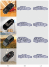
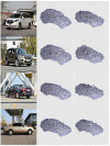
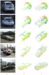
With the development of the laser scanning technique, it is easier to obtain 3D large-scale scene rapidly. However, many scanned objects may suffer serious incompletion caused by the scanning angles or occlusion, which has severely impacted their future usage for the 3D perception and modeling, while traditional point cloud completion methods often fails to provide satisfactory results due to the large missing parts. In this paper, by utilising 2D single-view images to infer 3D structures, we propose a data-driven Point Cloud Completion Network ( P C C N e t ), which is an image-guided deep-learning-based object completion framework. With the input of incomplete point clouds and the corresponding scanned image, the network can acquire enough completion rules through an encoder-decoder architecture. Based on an attention-based 2D-3D fusion module, the network is able to integrate 2D and 3D features adaptively according to their information integrity. We also propose a projection loss as an additional supervisor to have a consistent spatial distribution from multi-view observations. To demonstrate the effectiveness, first, the proposed P C C N e t is compared to recent generative networks and has shown more powerful 3D reconstruction abilities. Then, P C C N e t is compared to a recent point cloud completion methods, which has demonstrate that the proposed P C C N e t is able to provide satisfied completion results for objects with large missing parts.
Keywords: 3D reconstruction; mobile laser scanning; point cloud generation; point cloud object completion; single image.
Conflict of interest statement
The authors declare no conflict of interest.
Figures


References
-
- Yue X., Wu B., Seshia S.A., Keutzer K., Sangiovanni-Vincentelli A.L. A LiDAR Point Cloud Generator: From a Virtual World to Autonomous Driving; Proceedings of the ACM on International Conference on Multimedia Retrieval; Yokohama, Japan. 11–14 June 2018.
-
- Stets J.D., Sun Y., Corning W., Greenwald S. Visualization and Labeling of Point Clouds in Virtual Reality. arXiv. 2018. 1804.04111
-
- Balsabarreiro J., Lerma J.L. A new methodology to estimate the discrete-return point density on airborne lidar surveys. Int. J. Remote Sens. 2014;35:1496–1510. doi: 10.1080/01431161.2013.878063. - DOI
LinkOut - more resources
Full Text Sources
Other Literature Sources

