. 2019 Apr 1;12(4):235-241.
doi: 10.1038/s41561-019-0327-5. Epub 2019 Mar 28.

A deep groundwater origin for recurring slope lineae on Mars

Affiliations

A deep groundwater origin for recurring slope lineae on Mars

Abotalib Z Abotalib et al. Nat Geosci. .
No abstract available


Conflict of interest statement

Competing financial interests The authors declare no financial and non-financial competing interests.

Figures

Fig. 1.
Fig. 1.
RSL locations along fractured crater walls in the southern mid-latitudes of Mars. (a) Palikir crater ESP_022689_1380, (b) Unnamed crater within Newton crater basin ESP_040491_1375, (c) Triolet crater ESP_022808_1425, blue arrows refer to concentric fractures and red arrows refer to the pre-impact radial grabens. Inset is a close-up view to the intersection area between the concentric fractures and the pre-impact grabens and is highlighted in (c) with a purple box (d) Schematic diagram of crater wall fractures showing the distribution of radial and concentric fractures within terrestrial basalts and sandstones (modified from ref. 18, 19).
Fig. 2.
Fig. 2.
RSL occurrences in VM. (a) The distribution of normal faults (ref. 22), fault trace ridges (ref. 23) and RSL occurrences (ref. 12) over a MOLA /HRSC mosaic of VM showing the spatial correlation between these features. (b) The emergence of RSL in Coprates Chasma along highly deformed zone (yellow dashed lines). The location of (b) is located on Fig. 2a as a red star. (c) Detail from B showing multiple displacements of a marker horizontal strata along faults (white arrows) also shown is a dog-leg offset along linear ridges (yellow arrows) indicating high deformation of RSL source regions.
Fig. 3.
Fig. 3.
Fault control on RSL emergence in Palikir crater. (a) The intersection of concentric and radial fractures along the wall of Palikir crater during winter seasons ESP_021555_1380 and (b) during summer seasons ESP_022689_1380. Note the emergence of RSL during the summer season along discrete elevations in concordance with the locations of fractures. RSL are indicated with black arrows and elevation values are in purple.
Fig. 4.
Fig. 4.
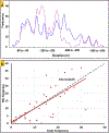
Correlation between faults and RSL. (a) The frequencies of concentric faults and RSL onsets showing a strong correlation at different elevations along the crater walls. (b) Pearson correlation coefficient between the frequencies of RSL and concentric faults showing a positive correlation between the two datasets. The frequencies of RSL onsets and fractures are counted in fixed 20 m buffer zones and elevation values are obtained from a 20 m contour map, hence all the measurements have uncertainty of 20 m. The trendline and the line of perfect correspondence are presented in red line and black dashed line respectively.
Fig. 5.
Fig. 5.
The control of seasonal melting and freezing of shallow subsurface on RSL activity. (a) During winter seasons the system shuts down when ascending brines freezes within fault pathways in the near-surface, (b) during summer seasons the system resumes when brine temperature rise above the freezing point.
Fig. 6.
Fig. 6.
Modeled outflow temperatures of groundwater discharge along the surface of Palikir crater fractured walls. The outflow temperature is modelled as a function of the flow parameter (ϒ) during winter (black lines) and summer (red lines) seasons under aquifer depths (zb) of 750 m as solid lines and 4.5 km as dashed lines. (a) and (b) are the outflow temperatures at geothermal gradient of 20 and 15°C km−1 respectively. ϒ at values of 2.79 km and 3.21 km are expressed in solid blue and dashed blue lines for aquifer depths of 750 m and 4.5 km respectively.

References

    1. McEwen AS et al. Seasonal flows on warm Martian slopes. Science 333, 740–743 (2011). - PubMed
    1. McEwen AS et al. Recurring slope lineae in equatorial regions of Mars. Nat. Geosci 7, 53 (2014).
    1. Ojha L et al. Spectral evidence for hydrated salts in recurring slope lineae on Mars. Nat. Geosci 8, 829–832 (2015).
    1. Martinez GM & Renno NO Water and brines on Mars: current evidence and implications for MSL. Space Sci. Rev 175, 29–51 (2013).
    1. Chevrier VF & Rivera‐Valentin EG Formation of recurring slope lineae by liquid brines on present‐day Mars. Geophys. Res. Lett 39 (2012).