

Geographic shifts in Aedes aegypti habitat suitability in Ecuador using larval surveillance data and ecological niche modeling: Implications of climate change for public health vector control
- PMID: 30995228
- PMCID: PMC6488096
- DOI: 10.1371/journal.pntd.0007322
Geographic shifts in Aedes aegypti habitat suitability in Ecuador using larval surveillance data and ecological niche modeling: Implications of climate change for public health vector control
Abstract
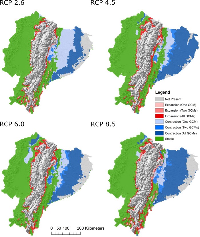
Arboviral disease transmission by Aedes mosquitoes poses a major challenge to public health systems in Ecuador, where constraints on health services and resource allocation call for spatially informed management decisions. Employing a unique dataset of larval occurrence records provided by the Ecuadorian Ministry of Health, we used ecological niche models (ENMs) to estimate the current geographic distribution of Aedes aegypti in Ecuador, using mosquito presence as a proxy for risk of disease transmission. ENMs built with the Genetic Algorithm for Rule-Set Production (GARP) algorithm and a suite of environmental variables were assessed for agreement and accuracy. The top model of larval mosquito presence was projected to the year 2050 under various combinations of greenhouse gas emissions scenarios and models of climate change. Under current climatic conditions, larval mosquitoes were not predicted in areas of high elevation in Ecuador, such as the Andes mountain range, as well as the eastern portion of the Amazon basin. However, all models projected to scenarios of future climate change demonstrated potential shifts in mosquito distribution, wherein range contractions were seen throughout most of eastern Ecuador, and areas of transitional elevation became suitable for mosquito presence. Encroachment of Ae. aegypti into mountainous terrain was estimated to affect up to 4,215 km2 under the most extreme scenario of climate change, an area which would put over 12,000 people currently living in transitional areas at risk. This distributional shift into communities at higher elevations indicates an area of concern for public health agencies, as targeted interventions may be needed to protect vulnerable populations with limited prior exposure to mosquito-borne diseases. Ultimately, the results of this study serve as a tool for informing public health policy and mosquito abatement strategies in Ecuador.
Conflict of interest statement
The authors have declared that no competing interests exist.
Figures


Similar articles
-
Mapping the global potential distributions of two arboviral vectors Aedes aegypti and Ae. albopictus under changing climate.PLoS One. 2018 Dec 31;13(12):e0210122. doi: 10.1371/journal.pone.0210122. eCollection 2018. PLoS One. 2018. PMID: 30596764 Free PMC article.
-
Modelling the potential distribution of arbovirus vector Aedes aegypti under current and future climate scenarios in Taiwan, China.Pest Manag Sci. 2019 Nov;75(11):3076-3083. doi: 10.1002/ps.5424. Epub 2019 Apr 16. Pest Manag Sci. 2019. PMID: 30919547
-
Modeling the present and future distribution of arbovirus vectors Aedes aegypti and Aedes albopictus under climate change scenarios in Mainland China.Sci Total Environ. 2019 May 10;664:203-214. doi: 10.1016/j.scitotenv.2019.01.301. Epub 2019 Feb 1. Sci Total Environ. 2019. PMID: 30743113
-
Zika Virus Mosquito Vectors: Competence, Biology, and Vector Control.J Infect Dis. 2017 Dec 16;216(suppl_10):S976-S990. doi: 10.1093/infdis/jix405. J Infect Dis. 2017. PMID: 29267910 Free PMC article. Review.
-
Climate change and viral emergence: evidence from Aedes-borne arboviruses.Curr Opin Virol. 2020 Feb;40:41-47. doi: 10.1016/j.coviro.2020.05.001. Epub 2020 Jun 20. Curr Opin Virol. 2020. PMID: 32569752 Free PMC article. Review.
Cited by
-
Predicting the Geographic Distribution of the Bacillus anthracis A1.a/Western North American Sub-Lineage for the Continental United States: New Outbreaks, New Genotypes, and New Climate Data.Am J Trop Med Hyg. 2020 Feb;102(2):392-402. doi: 10.4269/ajtmh.19-0191. Am J Trop Med Hyg. 2020. PMID: 31802730 Free PMC article.
-
Mapping Potential Malaria Vector Larval Habitats for Larval Source Management in Western Kenya: Introduction to Multimodel Ensembling Approaches.Am J Trop Med Hyg. 2024 Feb 13;110(3):421-430. doi: 10.4269/ajtmh.23-0108. Print 2024 Mar 6. Am J Trop Med Hyg. 2024. PMID: 38350135 Free PMC article.
-
Vector-borne zoonotic blood parasites in wildlife from Ecuador: A report and systematic review.Vet World. 2021 Jul;14(7):1935-1945. doi: 10.14202/vetworld.2021.1935-1945. Epub 2021 Jul 27. Vet World. 2021. PMID: 34475720 Free PMC article.
-
Identifying gaps on health impacts, exposures, and vulnerabilities to climate change on human health and wellbeing in South America: a scoping review.Lancet Reg Health Am. 2023 Aug 24;26:100580. doi: 10.1016/j.lana.2023.100580. eCollection 2023 Oct. Lancet Reg Health Am. 2023. PMID: 37876675 Free PMC article.
-
Scoping review of distribution models for selected Amblyomma ticks and rickettsial group pathogens.PeerJ. 2021 Feb 17;9:e10596. doi: 10.7717/peerj.10596. eCollection 2021. PeerJ. 2021. PMID: 33643699 Free PMC article.
References
-
- Alava A., Mosquera C., Vargas W., Real J. Dengue en el Ecuador 1989–2002. Rev Ecuat Hig Med Trop. 2005;42: 11–34.
-
- Fontenille D, Diallo M, Mondo M, Ndiaye M, Thonnon J. First evidence of natural vertical transmission of yellow fever virus in Aedes aegypti, its epidemic vector. Trans R Soc Trop Med Hyg. 1997;91: 533–535. - PubMed
-
- Pan American Health Organization, World Health Organization. Zika suspected and confirmed cases reported by countries and territories in the Americas. Cumulative cases, 2015–2016. [Internet]. PAN/WHO, Washington, D.C.; 2016. Available: http://www.paho.org/hq/index.php?option=com_content&view=article&id=1239...
Publication types
MeSH terms
LinkOut - more resources
Full Text Sources
Medical
Miscellaneous
