

Spatiotemporal analysis of regional socio-economic vulnerability change associated with heat risks in Canada
- PMID: 31031454
- PMCID: PMC6482004
- DOI: 10.1016/j.apgeog.2018.04.015
Spatiotemporal analysis of regional socio-economic vulnerability change associated with heat risks in Canada
Abstract
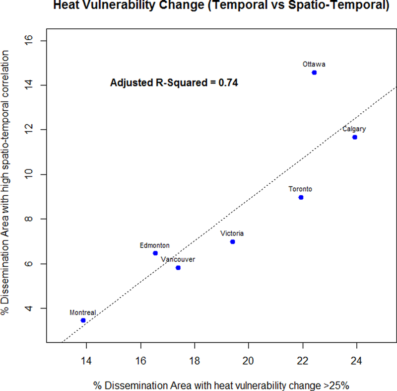
Excess mortality can be caused by extreme hot weather events, which are increasing in severity and frequency in Canada due to climate change. Individual and social vulnerability factors influence the mortality risk associated with a given heat exposure. We constructed heat vulnerability indices using census data from 2006 and 2011 in Canada, developed a novel design to compare spatiotemporal changes of heat vulnerability, and identified locations that may be increasingly vulnerable to heat. The results suggest that 1) urban areas in Canada are particularly vulnerable to heat, 2) suburban areas and satellite cities around major metropolitan areas show the greatest increases in vulnerability, and 3) heat vulnerability changes are driven primarily by changes in the density of older ages and infants. Our approach is applicable to heat vulnerability analyses in other countries.
Keywords: climate change; demographic change; heat vulnerability; regional planning; spatiotemporal modelling; urbanization.
Figures


Similar articles
-
A Spatial Framework to Map Heat Health Risks at Multiple Scales.Int J Environ Res Public Health. 2015 Dec 18;12(12):16110-23. doi: 10.3390/ijerph121215046. Int J Environ Res Public Health. 2015. PMID: 26694445 Free PMC article.
-
The Heat Exposure Integrated Deprivation Index (HEIDI): A data-driven approach to quantifying neighborhood risk during extreme hot weather.Environ Int. 2017 Dec;109:42-52. doi: 10.1016/j.envint.2017.09.011. Epub 2017 Sep 18. Environ Int. 2017. PMID: 28934628
-
Characterizing the role of socioeconomic pathways in shaping future urban heat-related challenges.Sci Total Environ. 2019 Dec 10;695:133941. doi: 10.1016/j.scitotenv.2019.133941. Epub 2019 Aug 15. Sci Total Environ. 2019. PMID: 31756866
-
Climate change and extreme heat events.Am J Prev Med. 2008 Nov;35(5):429-35. doi: 10.1016/j.amepre.2008.08.021. Am J Prev Med. 2008. PMID: 18929969 Review.
-
The potential impacts of climate variability and change on temperature-related morbidity and mortality in the United States.Environ Health Perspect. 2001 May;109 Suppl 2(Suppl 2):185-9. doi: 10.1289/ehp.109-1240665. Environ Health Perspect. 2001. PMID: 11359685 Free PMC article. Review.
Cited by
-
Knowledge Domain and Emerging Trends of Social Vulnerability Research: A Bibliometric Analysis (1991-2021).Int J Environ Res Public Health. 2022 Jul 8;19(14):8342. doi: 10.3390/ijerph19148342. Int J Environ Res Public Health. 2022. PMID: 35886193 Free PMC article. Review.
-
A Raster-Based Subdividing Indicator to Map Urban Heat Vulnerability: A Case Study in Sydney, Australia.Int J Environ Res Public Health. 2018 Nov 9;15(11):2516. doi: 10.3390/ijerph15112516. Int J Environ Res Public Health. 2018. PMID: 30423999 Free PMC article.
-
Mapping Heat-Related Risks in Northern Jiangxi Province of China Based on Two Spatial Assessment Frameworks Approaches.Int J Environ Res Public Health. 2020 Sep 10;17(18):6584. doi: 10.3390/ijerph17186584. Int J Environ Res Public Health. 2020. PMID: 32927631 Free PMC article.
-
Urban heat vulnerability: A dynamic assessment using multi-source data in coastal metropolis of Southeast China.Front Public Health. 2022 Oct 20;10:989963. doi: 10.3389/fpubh.2022.989963. eCollection 2022. Front Public Health. 2022. PMID: 36339225 Free PMC article.
-
Too hot! Preventing, recognizing and managing heat injury in children.Paediatr Child Health. 2022 Oct 8;28(2):72-74. doi: 10.1093/pch/pxac092. eCollection 2023 May. Paediatr Child Health. 2022. PMID: 37151923 Free PMC article.
References
-
- Adger WN (2006). Vulnerability. Global environmental change, 16(3), 268–281.
-
- Adger WN, Arnell NW, & Tompkins EL (2005). Successful adaptation to climate change across scales. Global environmental change, 15(2), 77–86.
-
- Ali K, Olfert MR, & Partridge MD (2011). Urban footprints in rural Canada: Employment spillovers by city size. Regional studies, 45(2), 239–260.
-
- Akbari AH, & Aydede Y (2012). Effects of immigration on house prices in Canada. Applied Economics, 44(13), 1645–1658.
-
- Aminipouri M, Knudby A, & Ho HC (2016). Using multiple disparate data sources to map heat vulnerability: Vancouver case study. The Canadian Geographer/Le Géographe canadien, 60(3), 356–368.
Grants and funding
LinkOut - more resources
Full Text Sources