. 2019 May 9;14(5):e0216223.
doi: 10.1371/journal.pone.0216223. eCollection 2019.

Right on track? Performance of satellite telemetry in terrestrial wildlife research

M P G Hofman  1   2 M W Hayward  2   3 M Heim  4 P Marchand  5   6 C M Rolandsen  4 J Mattisson  4 F Urbano  7 M Heurich  8   9 A Mysterud  10 J Melzheimer  11 N Morellet  12 U Voigt  13 B L Allen  14 B Gehr  15   16 C Rouco  17   18 W Ullmann  19   20 Ø Holand  21 N H Jørgensen  21 G Steinheim  21 F Cagnacci  22 M Kroeschel  8   23 P Kaczensky  4   24 B Buuveibaatar  25 J C Payne  25 I Palmegiani  11 K Jerina  26 P Kjellander  27 Ö Johansson  27   28 S LaPoint  29   30 R Bayrakcismith  31 J D C Linnell  4 M Zaccaroni  32 M L S Jorge  33 J E F Oshima  34 A Songhurst  35   36   37 C Fischer  38 R T Mc Bride Jr  39 J J Thompson  40   41   42 S Streif  23 R Sandfort  43 C Bonenfant  44   45 M Drouilly  46 M Klapproth  47 D Zinner  47 R Yarnell  48 A Stronza  35   37 L Wilmott  49 E Meisingset  50 M Thaker  51 A T Vanak  52   53   54 S Nicoloso  55 R Graeber  13 S Said  56 M R Boudreau  57 A Devlin  58   31 R Hoogesteijn  31 J A May-Junior  59   60   31 J C Nifong  61 J Odden  4 H B Quigley  31 F Tortato  31 D M Parker  62   63 A Caso  64   65 J Perrine  66 C Tellaeche  67 F Zieba  68 T Zwijacz-Kozica  68 C L Appel  69 I Axsom  69 W T Bean  69 B Cristescu  46   70 S Périquet  45   71 K J Teichman  70   72 S Karpanty  73 A Licoppe  74 V Menges  11 K Black  73 T L Scheppers  75 S C Schai-Braun  43 F C Azevedo  76   77 F G Lemos  76   77 A Payne  56 L H Swanepoel  78 B V Weckworth  31 A Berger  11 A Bertassoni  79 G McCulloch  35   36   37 P Šustr  80 V Athreya  81 D Bockmuhl  11 J Casaer  75 A Ekori  82 D Melovski  1   83 C Richard-Hansen  84   85 D van de Vyver  62 R Reyna-Hurtado  86 E Robardet  87 N Selva  88 A Sergiel  88 M S Farhadinia  89 P Sunde  90 R Portas  11 H Ambarli  91 R Berzins  84 P M Kappeler  92   93 G K Mann  31   94 L Pyritz  92   95 C Bissett  62 T Grant  62 R Steinmetz  96 L Swedell  97   98 R J Welch  62   63 D Armenteras  99 O R Bidder  100 T M González  99 A Rosenblatt  101 S Kachel  31   102 N Balkenhol  1
Affiliations

Right on track? Performance of satellite telemetry in terrestrial wildlife research

M P G Hofman et al. PLoS One. .

Abstract

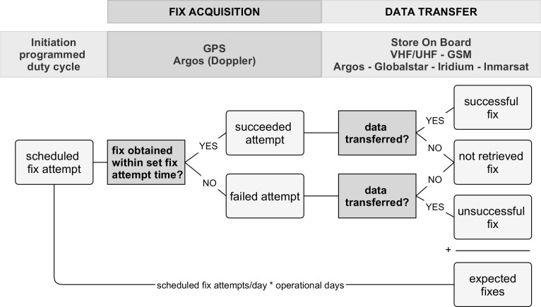
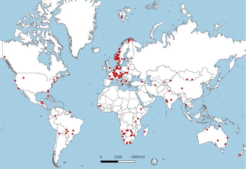
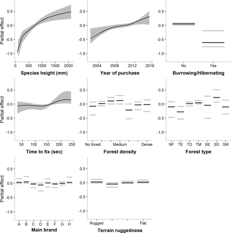
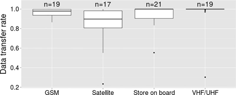
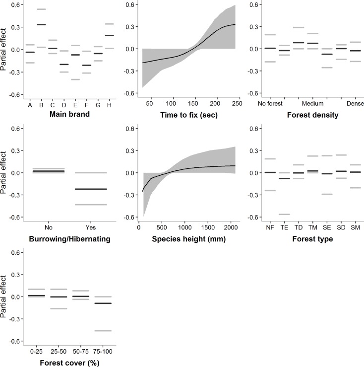
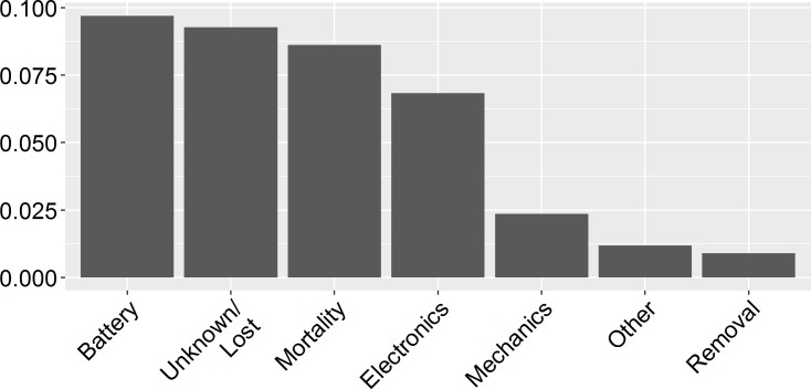
Satellite telemetry is an increasingly utilized technology in wildlife research, and current devices can track individual animal movements at unprecedented spatial and temporal resolutions. However, as we enter the golden age of satellite telemetry, we need an in-depth understanding of the main technological, species-specific and environmental factors that determine the success and failure of satellite tracking devices across species and habitats. Here, we assess the relative influence of such factors on the ability of satellite telemetry units to provide the expected amount and quality of data by analyzing data from over 3,000 devices deployed on 62 terrestrial species in 167 projects worldwide. We evaluate the success rate in obtaining GPS fixes as well as in transferring these fixes to the user and we evaluate failure rates. Average fix success and data transfer rates were high and were generally better predicted by species and unit characteristics, while environmental characteristics influenced the variability of performance. However, 48% of the unit deployments ended prematurely, half of them due to technical failure. Nonetheless, this study shows that the performance of satellite telemetry applications has shown improvements over time, and based on our findings, we provide further recommendations for both users and manufacturers.


Conflict of interest statement

I have read the journal's policy and the authors of this manuscript have the following competing interests: SN is employed by D.R.E.Am. Italia. JAM received funding from Bank of America, SCS from CIC Schweiz, FCA and FGL from Consórcio Capim Branco de Energia, and PK, BB, JCP from Sustainability East Asia LLC and Oyu Tolgoi mine. There are no patents, products in development or marketed products to declare. This does not alter our adherence to all the PLOS ONE policies on sharing data and materials.

Figures

Fig 1
Fig 1. Two-step satellite telemetry process.
The general two-step operation of terrestrial satellite telemetry units, and the possible fix outcomes of the process. The number of expected fixes equals the sum of successful, unsuccessful and not-retrieved fixes (see Materials and methods).
Fig 2
Fig 2. Project distribution.
The geographic distribution of all projects that provided information on the performance of satellite telemetry units. Note that each red dot can comprise more than one project.
Fig 3
Fig 3. Covariate partial effects on the mean Fix acquisition rate.
Mean-centered partial effects of the most important variables predicting the mean (μ) fix acquisition rate of satellite telemetry units (empirical confidence intervals in grey). Graphs are presented left-to-right in order of importance. Partial effects display the effect of the variable while accounting for all other variables in the model. Forest type levels: NF = No forest cover; TE = Temperate evergreen; TD = Temperate deciduous; TM = Temperate mixed; SE = (Sub)Tropical evergreen; SD = (Sub)Tropical deciduous; SM = (Sub)Tropical mixed.
Fig 4
Fig 4. Data transfer success.
Data transfer rate per main transfer method used in the projects.
Fig 5
Fig 5. Covariate partial effects on the mean Overall fix success rate.
Mean-centered partial effects of the most important variables predicting the mean (μ) overall fix success rate of satellite telemetry units (empirical confidence intervals in grey). Graphs are presented left-to-right in order of importance. Partial effects display the effect of the variable while accounting for all other variables in the model. Forest type levels: NF = No forest cover; TE = Temperate evergreen; TD = Temperate deciduous; TM = Temperate mixed; SE = (Sub)Tropical evergreen; SD = (Sub)Tropical deciduous; SM = (Sub)Tropical mixed.
Fig 6
Fig 6. Causes for premature ending of deployments.
Proportion of reported deployments ending prematurely due to various unit or animal-related factors.

References

    1. Cagnacci F, Boitani L, Powell RA, Boyce MS. Animal ecology meets GPS-based radiotelemetry: a perfect storm of opportunities and challenges. Philos Trans R Soc Lond B Biol Sci. 2010;365: 2157–2162. 10.1098/rstb.2010.0107 - DOI - PMC - PubMed
    1. Kays R, Crofoot MC, Jetz W, Wikelski M. Terrestrial animal tracking as an eye on life and planet. Science; 2015;348: aaa2478 10.1126/science.aaa2478 - DOI - PubMed
    1. Thomas B, Holland JD, Minot EO. Wildlife tracking technology options and cost considerations. Wildl Res. 2011;38: 653–663.
    1. Tomkiewicz SM, Fuller MR, Kie JG, Bates KK. Global positioning system and associated technologies in animal behaviour and ecological research. Philos Trans R Soc Lond B Biol Sci. 2010;365: 2163–76. 10.1098/rstb.2010.0090 - DOI - PMC - PubMed
    1. Eriksen A, Wabakken P, Zimmermann B, Andreassen HP, Arnemo JM, Gundersen H, et al. Activity patterns of predator and prey: A simultaneous study of GPS-collared wolves and moose. Anim Behav. Elsevier Ltd; 2011;81: 423–431. 10.1016/j.anbehav.2010.11.011 - DOI

Publication types