. 2019 Apr;12(4):247-252.
doi: 10.1038/s41561-019-0330-x. Epub 2019 Mar 19.

Shape of (101955) Bennu indicative of a rubble pile with internal stiffness

Affiliations

Shape of (101955) Bennu indicative of a rubble pile with internal stiffness

O S Barnouin et al. Nat Geosci. 2019 Apr.

Abstract

The shapes of asteroids reflect interplay between their interior properties and the processes responsible for their formation and evolution as they journey through the Solar System. Prior to the OSIRIS-REx (Origins, Spectral Interpretation, Resource Identification, and Security-Regolith Explorer) mission, Earth-based radar imaging gave an overview of (101955) Bennu's shape. Here, we construct a high-resolution shape model from OSIRIS-REx images. We find that Bennu's top-like shape, considerable macroporosity, and prominent surface boulders suggest that it is a rubble pile. High-standing, north-south ridges that extend from pole to pole, many long grooves, and surface mass wasting indicate some low levels of internal friction and/or cohesion. Our shape model indicates that, similar to other top-shaped asteroids, Bennu formed by reaccumulation and underwent past periods of fast spin leading to its current shape. Today, Bennu might follow a different evolutionary pathway, with interior stiffness permitting surface cracking and mass wasting.


Figures
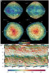
Figure 1:
Figure 1:. The global digital terrain model (GDTM) of Bennu.
Several views of the GDTM are shown, colourized by elevation (a). A shaded relief of the GDTM with slopes is shown in b. The poles of Bennu are high, and the equator is a low-lying region. OLA footprint locations are overlain (white spots). The GDTM has a resolution of ~0.8 m per facet and a total of 1.5 million facets. The textured appearance in many regions of the GDTM is not noise, but evidence for m scale boulders influencing the roughness of the model.
Figure 2:
Figure 2:. Amplitude spectrum of a spherical harmonic expansion for the GDTM.
Black circles indicate the total amplitude at each spherical harmonics degree. Zonal terms (red) describe contributions to the shape that vary only with latitude; sectoral contributions (blue) vary only with longitude. The large zonal degree-2 and degree-4 terms are a consequence of Bennu’s top shape and equatorial ridge. The relatively low amplitudes of the degree-3 and degree-5 terms demonstrate that there is no substantial north-south asymmetry. The degree-4 sectoral terms capture the ~90° longitudinal variations in Bennu’s shape resulting from the major north-south ridges, with their root-mean-square globally averaged amplitude of 8 to 10 m.
Figure 3:
Figure 3:. Deviations of Bennu's radius from that of a circle, for different latitudinal cross-sections.
a, Best-fit circles for the circumference of Bennu at 0°, 30°N, and 60°N overlain on radius measurements of Bennu’s shape cross-sections and colour-coded by deviations from the circle. b, Deviations from the circular shape for 0°, 30°N, and 60°N. The shaded regions represent consistently elevated topography above the best-fit circles, interpreted as roughly longitudinally oriented ridges. At least two of the ridges extend from the north to south high-latitude regions. Arrows indicate locations of candidate craters [14] that have small wavelength contributions to the equatorial shape. (c,d) Similar plots for the southern hemisphere.
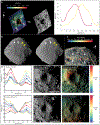
Figure 4:
Figure 4:. DTMs and Images of geological features that contribute to the shape of Bennu.
Large boulders, (e.g., 45°S, 132°E; a), influence the global attributes of the GDTM. Additional contributors to the shape include long grooves (b, yellow arrows), scarps (b and c, white arrows), mass wasting (dashed line in b; see more details in [14]), and craters (d). The local DTM of the boulder in a has a 1.12 m RMS error derived from the OLA returns, shown as yellow dots in the left panel. The bottom crater has overlapping OLA returns, where the RMS difference between the OLA points and local DTM is 45 cm. The d/D of the top and bottom craters in d are 0.24 ± 0.03 and 0.14 ± 0.02 respectively, with respect to elevation. See methods for more information.

References

    1. Nolan M et al. Shape model and surface properties of the OSIRIS-REx target asteroid (101955) Bennu from radar and lightcurve observations. Icarus 226, 629–640. (2013).
    1. Hergenrother CW et al. Lightcurve, color and phase function photometry of the OSIRIS-REx target asteroid (101955) Bennu. Icarus 226, 663–670 (2013).
    1. Rizk B, et al. OCAMS: The OSIRIS-REx Camera Suite. Space Sci. Rev. 214, 26, (2018). - PMC - PubMed
    1. Gaskell RW, et al. Characterizing and navigating small bodies with imaging data. Meteorit. Planet. Sci. 43, 1049–1061 (2008).
    1. Daly MG, et al. The OSIRIS-REx Laser Altimeter (OLA) Investigation and Instrument. Space Sci. Rev. 198, 1–26. (2017).