

Geographic accessibility to public health facilities providing tuberculosis testing services at point-of-care in the upper east region, Ghana
- PMID: 31182068
- PMCID: PMC6558903
- DOI: 10.1186/s12889-019-7052-2
Geographic accessibility to public health facilities providing tuberculosis testing services at point-of-care in the upper east region, Ghana
Abstract
Background: In Ghana, limited evidence exists about the geographical accessibility to health facilities providing tuberculosis (TB) diagnostic services to facilitate early diagnosis and treatment. Therefore, we aimed to assess the geographic accessibility to public health facilities providing TB testing services at point-of-care (POC) in the Upper East Region (UER), Ghana.
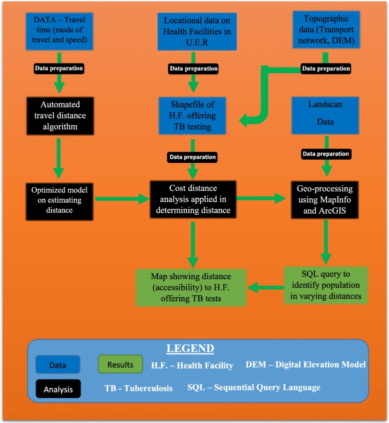
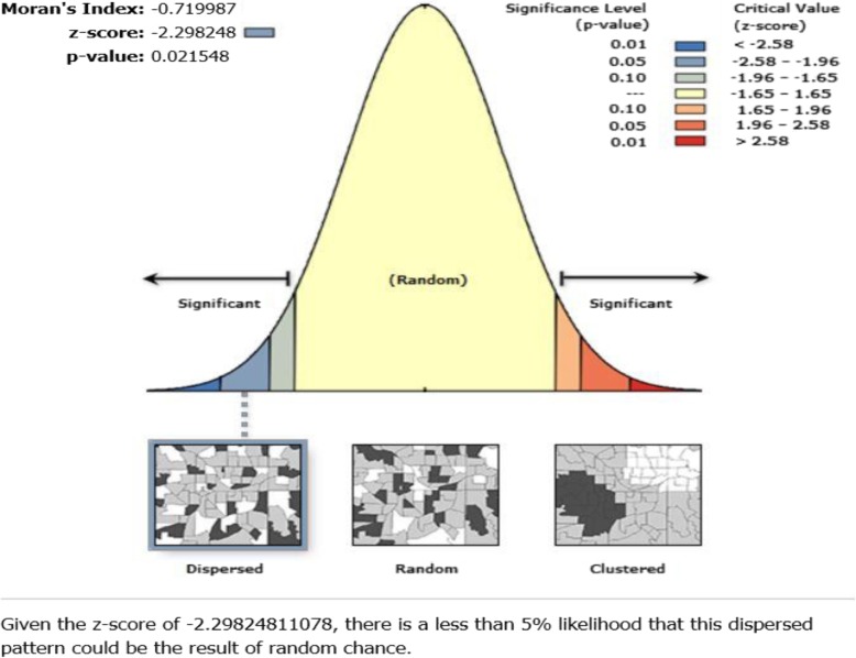
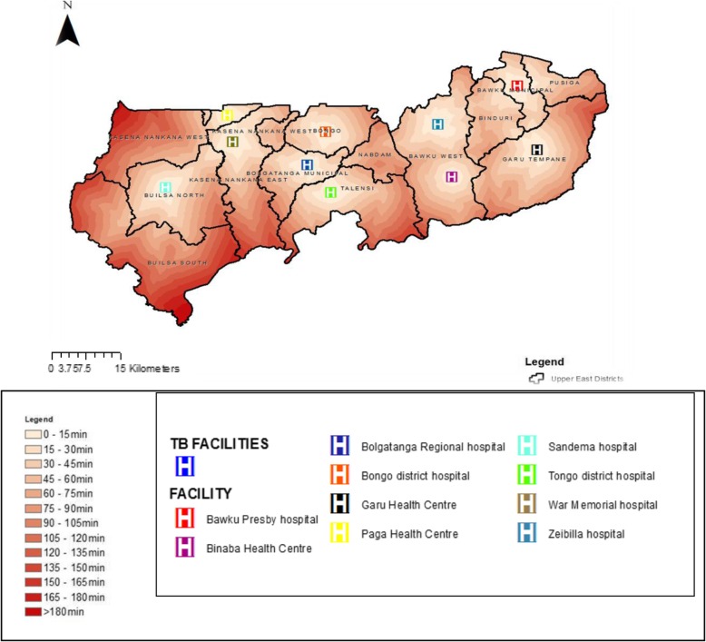
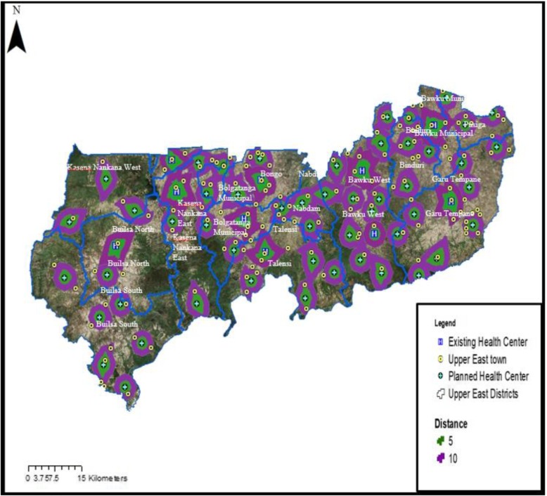
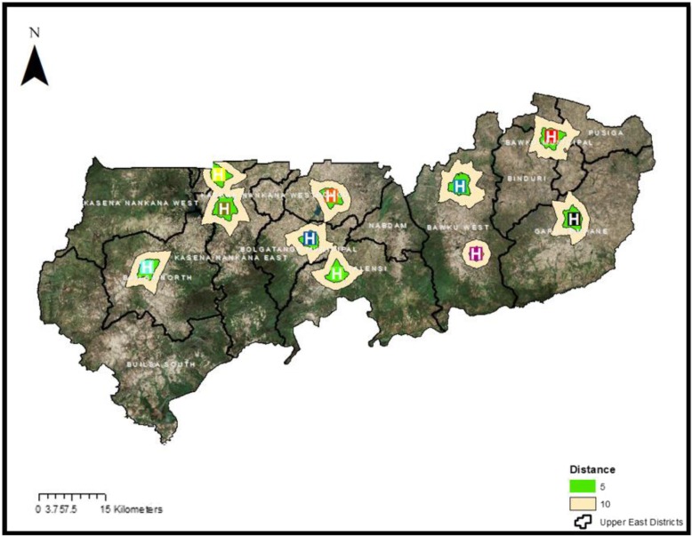
Methods: We assembled detailed spatial data on all 10 health facilities providing TB testing services at POC, and landscape features influencing journeys. These data were used in a geospatial model to estimate actual distance and travel time from the residential areas of the population to health facilities providing TB testing services. Maps displaying the distance values were produced using ArcGIS Desktop v10.4. Spatial distribution of the health facilities was done using spatial autocorrelation (Global Moran's Index) run in ArcMap 10.4.1. We also applied remote sensing through satellite imagery analysis to map out residential areas and identified locations for targeted improvement in the UER.
Results: Of the 13 districts in the UER, 4 (31%) did not have any health facility providing TB testing services. In all, 10 public health facilities providing TB testing services at POC were available in the region representing an estimated population to health facility ratio of 125,000 people per facility. Majority (60%) of the health facilities providing TB testing services in the region were in districts with a total population greater than 100,000 people. Majority (62%) of the population resident in the region were located more than 10 km away from a health facility providing TB testing services. The mean distance ± standard deviation to the nearest public health facility providing TB testing services in UER was 33.2 km ± 13.5. Whilst the mean travel time using a motorized tricycle speed of 20 km/h to the nearest facility providing TB testing services in the UER was 99.6 min ± 41.6. The results of the satellite imagery analysis show that 51 additional health facilities providing TB testing services at POC are required to improve geographical accessibility. The results of the spatial autocorrelation analysis show that the spatial distribution of the health facilities was dispersed (z-score = - 2.3; p = 0.02).
Conclusion: There is poor geographic accessibility to public health facilities providing TB testing services at POC in the UER of Ghana. Targeted improvement of rural PHC clinics in the UER to enable them provide TB testing services at POC is highly recommended.
Keywords: Accessibility; Distribution; Geographic; Ghana; Health facilities; Point-of-care testing; Tuberculosis; Upper east region.
Conflict of interest statement
The authors declare that they have no competing interests.
Figures
Similar articles
-
Geographical Accessibility to District Hospitals/Medical Laboratories for Comprehensive Antenatal Point-of-Care Diagnostic Services in the Upper East Region, Ghana.EClinicalMedicine. 2019 Jul 3;13:74-80. doi: 10.1016/j.eclinm.2019.06.015. eCollection 2019 Aug. EClinicalMedicine. 2019. PMID: 31517264 Free PMC article.
-
Geographical access to point-of-care testing for hypertensive disorders of pregnancy as an integral part of maternal healthcare in Ghana.BMC Pregnancy Childbirth. 2020 Nov 25;20(1):733. doi: 10.1186/s12884-020-03441-6. BMC Pregnancy Childbirth. 2020. PMID: 33238918 Free PMC article.
-
Estimating the Spatial Accessibility to Blood Group and Rhesus Type Point-of-Care Testing for Maternal Healthcare in Ghana.Diagnostics (Basel). 2019 Nov 5;9(4):175. doi: 10.3390/diagnostics9040175. Diagnostics (Basel). 2019. PMID: 31694228 Free PMC article.
-
The contribution of private health facilities to the urban tuberculosis program of Afghanistan.Indian J Tuberc. 2023 Jan;70(1):8-11. doi: 10.1016/j.ijtb.2022.03.005. Epub 2022 Mar 23. Indian J Tuberc. 2023. PMID: 36740323 Review.
-
Improving the Accessibility and Efficiency of Point-of-Care Diagnostics Services in Low- and Middle-Income Countries: Lean and Agile Supply Chain Management.Diagnostics (Basel). 2017 Nov 29;7(4):58. doi: 10.3390/diagnostics7040058. Diagnostics (Basel). 2017. PMID: 29186013 Free PMC article. Review.
Cited by
-
Using geographic rescue time contours, point-of-care strategies, and spatial care paths to prepare island communities for global warming, rising oceans, and weather disasters.Int J Health Geogr. 2023 Dec 20;22(1):38. doi: 10.1186/s12942-023-00359-y. Int J Health Geogr. 2023. PMID: 38124128 Free PMC article.
-
Use of Physical Accessibility Modelling in Diagnostic Network Optimization: A Review.Diagnostics (Basel). 2022 Jan 4;12(1):103. doi: 10.3390/diagnostics12010103. Diagnostics (Basel). 2022. PMID: 35054270 Free PMC article. Review.
-
Improving geographical accessibility modeling for operational use by local health actors.Int J Health Geogr. 2020 Jul 6;19(1):27. doi: 10.1186/s12942-020-00220-6. Int J Health Geogr. 2020. PMID: 32631348 Free PMC article.
-
Predicting health services utilization using a score of perceived barriers to medical care: evidence from rural Senegal.BMC Health Serv Res. 2023 Mar 16;23(1):263. doi: 10.1186/s12913-023-09192-2. BMC Health Serv Res. 2023. PMID: 36927564 Free PMC article.
-
Geographical Accessibility to District Hospitals/Medical Laboratories for Comprehensive Antenatal Point-of-Care Diagnostic Services in the Upper East Region, Ghana.EClinicalMedicine. 2019 Jul 3;13:74-80. doi: 10.1016/j.eclinm.2019.06.015. eCollection 2019 Aug. EClinicalMedicine. 2019. PMID: 31517264 Free PMC article.
References
-
- World Health Organization. Global tuberculosis report 2017. Geneva: The World Health Organization; 2017. https://www.who.int/tb/publications/global_report/gtbr2017_main_text.pdf. [Accessed 7 June 2019].
-
- Gupta-Wright A, Corbett EL, van Oosterhout JJ, Wilson D, Grint D, Alufandika-Moyo M, et al. Rapid urine-based screening for tuberculosis in HIV-positive patients admitted to hospital in Africa (STAMP): a pragmatic, multicentre, parallel-group, double-blind, randomised controlled trial. Lancet. 2018;392(10144):292–301. doi: 10.1016/S0140-6736(18)31267-4. - DOI - PMC - PubMed
-
- Dodd Peter J, Yuen Courtney M, Becerra Mercedes C, Revill Paul, Jenkins Helen E, Seddon James A. Potential effect of household contact management on childhood tuberculosis: a mathematical modelling study. The Lancet Global Health. 2018;6(12):e1329–e1338. doi: 10.1016/S2214-109X(18)30401-7. - DOI - PMC - PubMed
-
- Bjerrum S, Kenu E, Lartey M, Newman MJ, Addo KK, Andersen AB, et al. Diagnostic accuracy of the rapid urine lipoarabinomannan test for pulmonary tuberculosis among HIV-infected adults in Ghana–findings from the DETECT HIV-TB study. BMC Infect Dis. 2015;15(1):407. doi: 10.1186/s12879-015-1151-1. - DOI - PMC - PubMed
-
- World Health Organization . Ghana Tuberculosis Profile. 2017.
MeSH terms
LinkOut - more resources
Full Text Sources
Medical
Molecular Biology Databases
