doi: 10.1001/jamasurg.2019.1720.
Use of a Statewide Public Health Tool to Estimate Miles Driven by Intoxicated Drivers
Affiliations
- PMID: 31215982
- PMCID: PMC6584894
- DOI: 10.1001/jamasurg.2019.1720
Item in Clipboard
Use of a Statewide Public Health Tool to Estimate Miles Driven by Intoxicated Drivers
JAMA Surg.
.
Abstract
This study uses data from the Place of Last Drink database and Google maps to assess the association of blood alcohol concentration with distance traveled and driver’s age among intoxicated drivers in Minnesota.
Conflict of interest statement
Figures
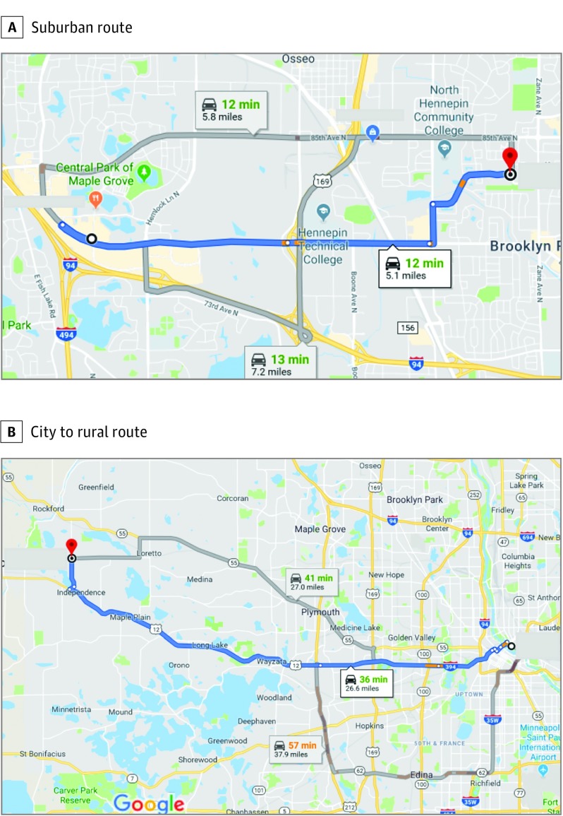
A, “Suggested route” options identified 3 preferred routes between a suburban place of last drink and the location of the police citation, ranging from 5.1 to 7.2 miles, with approximately 1.2 miles on highway and travel times between 12 and 13 minutes. B, Example of suggested routes for travel from a downtown place of last drink to a rural offense location requiring driving distances that ranged from 26.6 to 37.9 miles, including more than 25 miles of highway travel (using either I-394 and Highway 12 or on Highway 55) or more than 35 miles highway travel (on I-35W, I-494, and Highway 12). To convert miles to kilometers, multiply by 1.6.
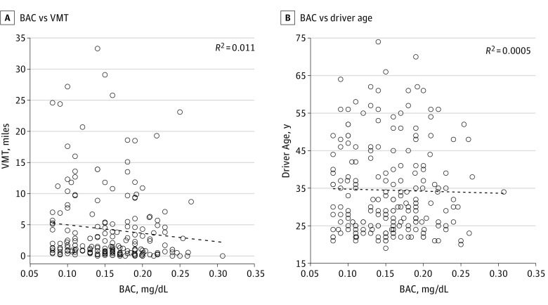
The variables BAC, VMT, and age were analyzed to assess the presence of associations among these variables. Because initial sample selections were based on BAC, this variable is plotted on the x-axis. A, Scatterplot and trend line of VMT vs BAC shows no statistically significant association between VMT and BAC. B, Scatterplot and trend line of age vs BAC shows no statistically significant association between driver age and BAC.
References
-
- Alcohol-impaired driving. Traffic Safety Facts, 2017 data. NHTSA’s National Center for Statistics and Analysis Motor Vehicle Traffic Crash Data website. https://crashstats.nhtsa.dot.gov/Api/Public/ViewPublication/812630. Published November 2018. Accessed May 8, 2019.
-
- Place of Last Drink (POLD) website. http://poldsystem.com. Accessed March 20, 2019.
-
- Levitt SD, Porter J. How dangerous are drinking drivers? J Polit Econ. 2001;109:1198-1237. doi:10.1086/323281 - DOI
Publication types
MeSH terms
LinkOut - more resources
Full Text Sources
Medical