. 2019 Jun 26;14(6):e0215668.
doi: 10.1371/journal.pone.0215668. eCollection 2019.

Persistent Neanderthal occupation of the open-air site of 'Ein Qashish, Israel

Affiliations

Persistent Neanderthal occupation of the open-air site of 'Ein Qashish, Israel

Ravid Ekshtain et al. PLoS One. .

Abstract

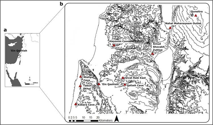
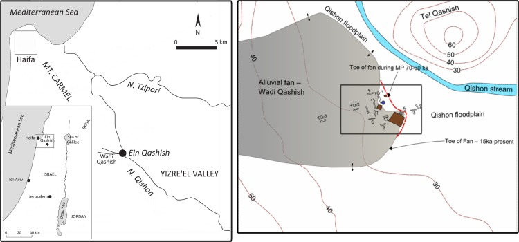
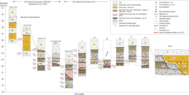
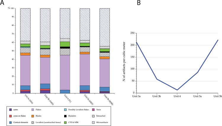
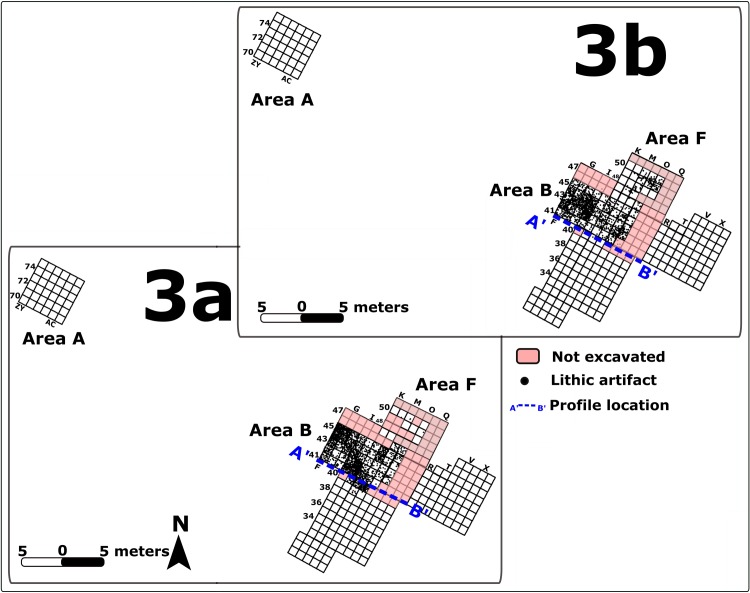
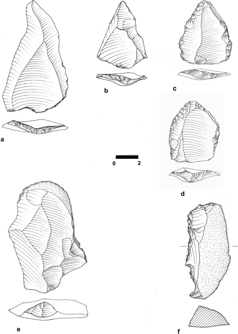
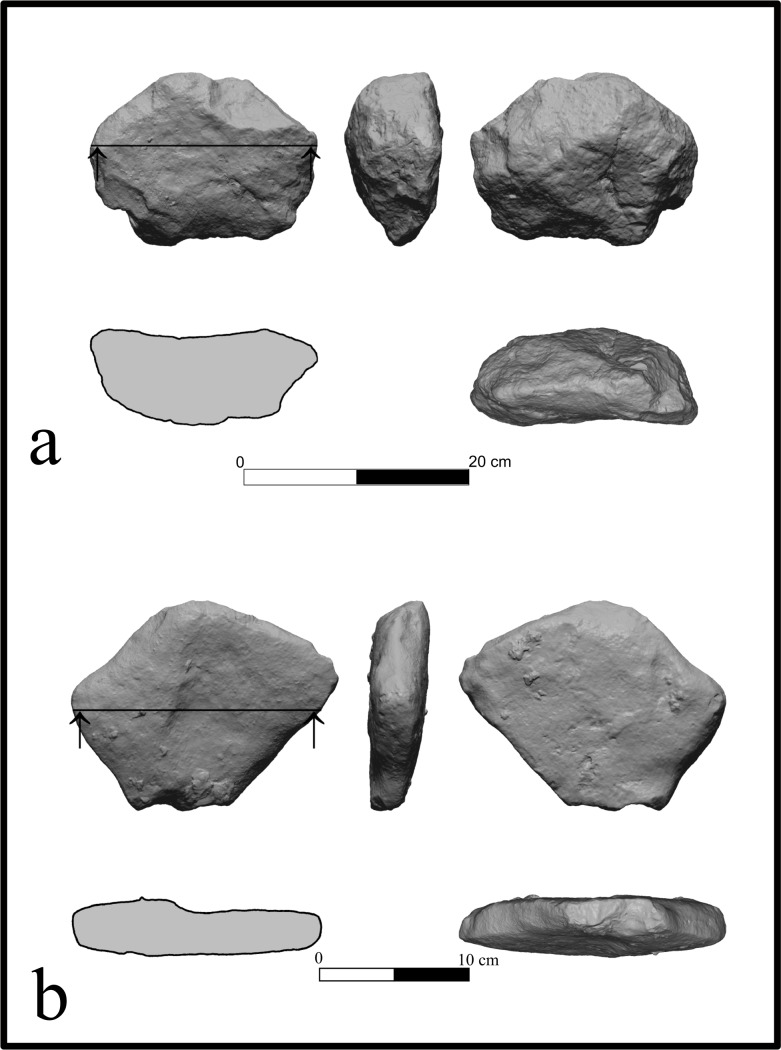
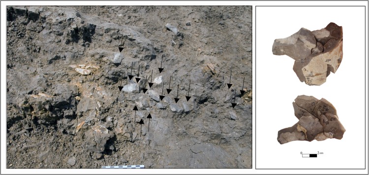
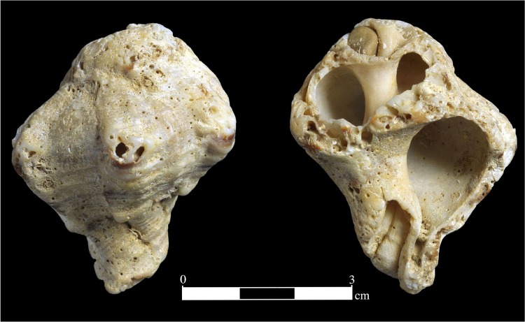
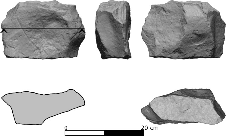
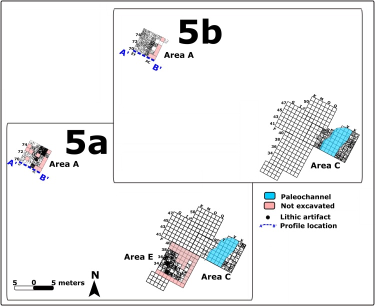
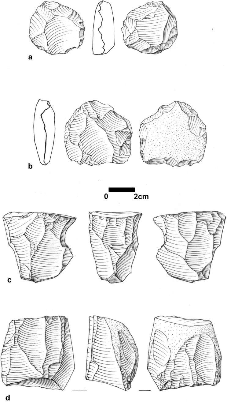
Over the last two decades, much of the recent efforts dedicated to the Levantine Middle Paleolithic has concentrated on the role of open-air sites in the settlement system in the region. Here focus on the site of 'Ein Qashish as a cases study. Located in present-day northern Israel, the area of this site is estimated to have been >1300 m2, of which ca. 670 were excavated. The site is located at the confluence of the Qishon stream with a small tributary running off the eastern flanks of the Mt. Carmel. At the area of this confluence, water channels and alluvial deposits created a dynamic depositional environment. Four Archaeological Units were identified in a 4.5-m thick stratigraphic sequence were dated by Optically Stimulated Luminescence (OSL) to between-71 and 54 ka, and probably shorter time span-~70-~60 ka. Here we present the diverse material culture remains from the site (lithics, including refitted sequences; modified limestone pieces; molluscs; faunal remains) against their changing paleogeographic backdrop. Skeletal evidence suggests that these remains were associated with Neanderthals. The large-scale repeated accumulation of late Middle Paleolithic remains in the same place on the landscape provides a unique opportunity to address questions of occupation duration and intensity in open-air sites. We find that each occupation was of ephemeral nature, yet presents a range of activities, suggesting that the locale has been used as a generalized residential site rather than specialized task-specific ones. This role of 'Ein Qashish did not change through time, suggesting that during the late Middle Paleolithic settlement system in this part of the southern Levant were stable.


Conflict of interest statement

The authors received funding from Derekh Eretz Inc. This does not alter our adherence to all the PLOS ONE policies on sharing data and materials.

Figures

Fig 1
Fig 1. MP sites in northern Israel.
Map: drown by R. Ekshtain using ArcMap 10.6.
Fig 2
Fig 2. Location of the site of ‘Ein Qashish.
Left: The location of ‘Ein Qashish in the Yizra’el valley. Right: a close-up map of the site’s environments. Grey area represents the present-day alluvial fan of Wadi Qashish. The changes in the fan’s eastern boundary during the occupations of the Middle Paleolithic (red dashed line). Excavation areas are shown as brown rectangles. TQ-1 –TQ-3 are geological trenches excavated during 2009–2011. Otherwise, trench numbers represent geological trenches made by IAA in 2012. Map down by R. Ekshtain using ArcMap 10.6.
Fig 3
Fig 3. The ‘Ein Qashish excavation areas.
Left: Spatial relationship between the 2009–2011 and 2013 excavation areas. The green area represents the extent of the archaeological site as reconstructed from the excavated areas and geological trenches. Right: Map of the 2013 excavation areas. Black lines represent indicative sections shown in Fig 4. Map down by R. Ekshtain using ArcMap 10.6.
Fig 4
Fig 4. Stratigraphic correlations and OSL chronology across the ‘Ein Qashish site.
Drawing: N. Yoselevich.
Fig 5
Fig 5. Assemblage composition and artifact densities.
A. Frequencies of artifacts by lithic technological categories in the archaeological units at EQ. B. Overall artifact densities (n/m3) along the stratigraphic sequence. Note that we present corrected data (see text) for Units 5a and 5b. Raw data for this figure are provided in Table b in S2 Table and in S3 Table.
Fig 6
Fig 6. Lateral distribution of lithic artifacts in unit 3a and in unit 3b.
Dashed blue line marks the location of the vertical distribtuion of artfiacts shown in S1 Fig. GIS rendition: R. Ekshtain [47].
Fig 7
Fig 7. Debitage and tools from EQ.
a: Levallois point (#F1844), Unit 3a Area B; b: Levallois point (#F2295), Unit 3a Area B; c: Side-scraper (#F1031), Unit 5b Area A; d: Side-scraper (#F1219), Unit 5a, Area A; e: Atypical end-scraper (#F1594), Unit 3a, Area B; f: A composite tool side- and end0scraper on cortical blade (#F1134), Unit 5b, Area A. With permission from M. Smelansky.
Fig 8
Fig 8. Modified limestone pieces (MLP) from archaeological unit 3a.
a. MLP#3, Area B; b. MLP#4, Area F. With permission from the Computerized Archaeology Laboratory, The Institute of Archaeology, The Hebrew University of Jerusalem.
Fig 9
Fig 9. Lithic refits.
Left: One of the refitting sequences as seen in the field; Area B Unit 3b. Photo E. Hovers. Right: Part of the refitted knapping sequence (two views of the same aggregate). Photo N. Mitki.
Fig 10
Fig 10. Hexaplex trunculus mollusk (#M1095), Unit 3b, Area B.
With permission from Clara Amit.
Fig 11
Fig 11. Modified limestone piece (MLP #1), Unit 3b, Area B.
With permission from the Computerized Archaeology Laboratory, The Institute of Archaeology, The Hebrew University of Jerusalem.
Fig 12
Fig 12. Lateral distribution of lithic artifacts in Units 5a and 5b in Areas A, C and E.
Location of a late (Islamic period) channel in Area C shown in blue. The vertical distribution along the marked profile line is shown in S2 Fig GIS rendition: R. Ekshtain [47].
Fig 13
Fig 13. Cores form EQ.
a: Levallois core (#F738), Unit 5a Area A; b: Core on flake (#F736), Unit 5a, Area A; c: single platfrom cores for the productions of blades/bladelets (#F743), Unit 5a Area A; d: non Levallois core for blades and flakes (#F1044), Unit 5b, Area B. With permission from M. Smelansky.
Fig 14
Fig 14. A sequence of refited flakes and blades, Area A.
Left—top view, showing the dorsal face of the first flake in this sequence and parts of scars from later flakes in the sequence. Arrows mark the direction of previous removals. Right—side view of the same sequence, showing the sequential removals of flakes from the same striking platfrom of a prepared core. Drawing and photos N. Mitki.
Fig 15
Fig 15. Distribution map of the remains of EQH3.
The five lower limb bones of EQH3 (modified form [33] and the location of a sixth bone (marked by X; see description in the text) are shown in relation to non-hominin finds. GIS rendition: R. Ekshtain.
Fig 16
Fig 16. Distributions (top row) and densities (bottom row) of non-burnt and burnt flint artifacts in Area B, Unit 3a and Unit 3b.
Kernel density was calculated according to standard deviation using ArcMap 10.3 search radius = 1. Unexcavated areas shown in pink. GIS renditions: R. Ekshtain.

References

    1. Sharon G, Zaidner Y, Hovers E. Opportunities, problems and future directions in the study of open-air Middle Paleolithic sites. Quat Int. 2014;331: 1–5. 10.1016/j.quaint.2014.03.055 - DOI
    1. Hovers E. The Lithic Assemblages of Qafzeh Cave. New York: Oxford University Press; 2009.
    1. Sackett JR. Straight archaeology French-style: the phylogenetic paradigm in historic perspective In: Clark GA, editor. Perspectives on the past: theoretical biases in Mediterranean hunter-gatherer research. Philadelphia: University of Pennsylvania; 1991. pp. 109–139.
    1. Bar Yosef O, Goren N. Afterthoughts Following Prehistoric Surveys in the Levant. Isr Explor J. 1980;30: 1–16.
    1. Bailey G. Time perspectives, palimpsests and the archaeology of time. J Anthropol Archaeol. 2007;26: 198–223. 10.1016/j.jaa.2006.08.002 - DOI

Publication types