

FLOTROP, a massive contribution to plant diversity data for open ecosystems in northern tropical Africa
- PMID: 31285431
- PMCID: PMC6614464
- DOI: 10.1038/s41597-019-0120-8
FLOTROP, a massive contribution to plant diversity data for open ecosystems in northern tropical Africa
Abstract
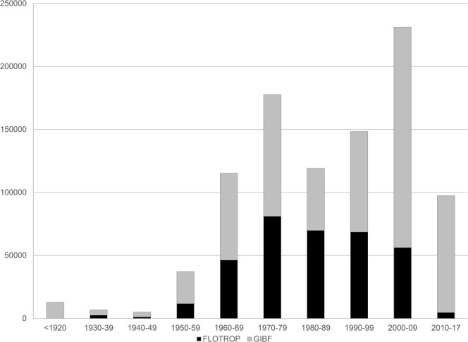
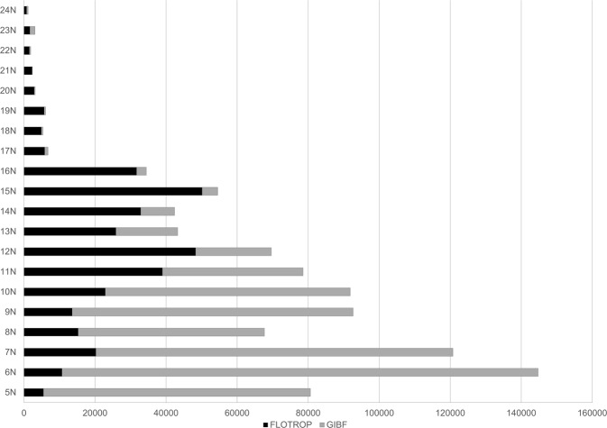
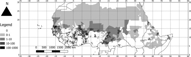
The FLOTROP dataset contains numerous plant observations (around 340,000 occurrences) in northern tropical Africa (from the 5th to 25th parallel north) in open ecosystems (savannah and steppe). They were collected by multiple collectors between 1920 and 2012 and were managed by Philippe Daget. These observations are probably the most important and unique source of plant distribution over the Sahel area. The data are now available in the Global Biodiversity Information Facility, Tela Botanica website, and as maps in the African Plant Database. For the overall area involved, this dataset has increased by 40% the data available in the GBIF. For some countries between the 15th and 21st parallel north, the FLOTROP dataset has increased available occurrences 10-fold compared to the data existing in the GBIF.
Conflict of interest statement
The authors declare no competing interests.
Figures
References
-
- Le Houerou, H. N. The rangelands of the Sahel. Journal of Range Management 41–46 (1980).
-
- Assouma M, et al. How to better account for livestock diversity and fodder seasonality in assessing the fodder intake of livestock grazing semi-arid sub-Saharan Africa rangelands. Livestock Science. 2018;216:16–23. doi: 10.1016/j.livsci.2018.07.002. - DOI
-
- Fortin, D., Lô, M., Maynart, G. & Arseneault, C. Plantes médicinales du Sahel. (AGRIS, 1990).
-
- Hiernaux, P., de Leeuw, P. & Diarra, L. The interactive effects of rainfall, nutrient supply and defoliation on the herbage yields of Sahelian rangelands in north-east Mali. In Proceedings of the International Conference on Livestock and Sustainable Nutrient Cycling in Mixed Farming Systems of Sub-Saharan Africa. (Addis Ababa, Ethiopia, 1995).
-
- Hiernaux P. Effects of grazing on plant species composition and spatial distribution in rangelands of the Sahel. Plant Ecology. 1998;138:191–202. doi: 10.1023/A:1009752606688. - DOI
Publication types
MeSH terms
LinkOut - more resources
Full Text Sources
Other Literature Sources
Research Materials
