. 2019 Jul 30;116(31):15425-15434.
doi: 10.1073/pnas.1903421116. Epub 2019 Jul 15.

Background gamma radiation and soil activity measurements in the northern Marshall Islands

Affiliations

Background gamma radiation and soil activity measurements in the northern Marshall Islands

Maveric K I L Abella et al. Proc Natl Acad Sci U S A. .

Abstract

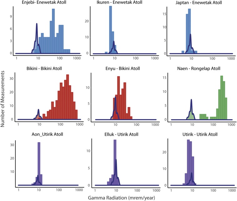
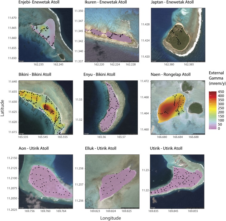
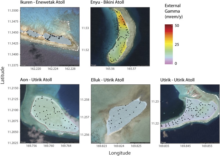
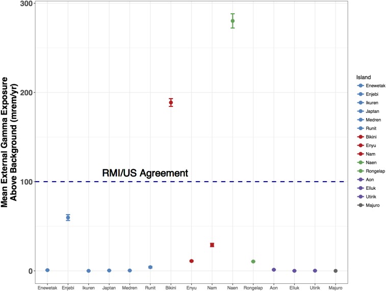
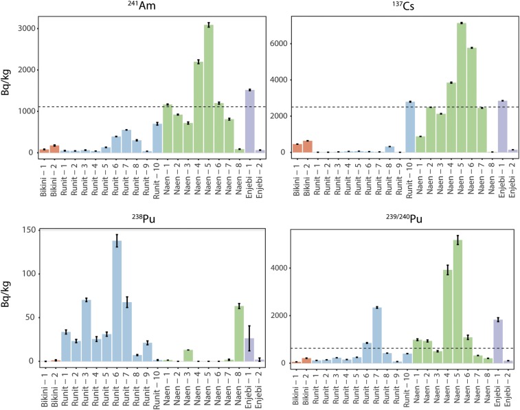
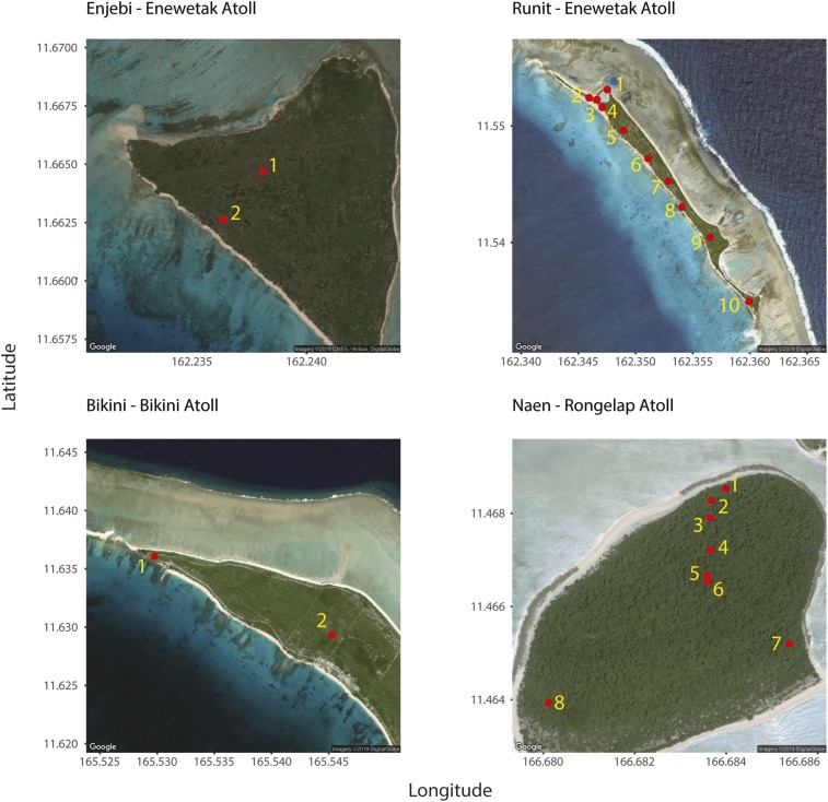
We report on measurements of external gamma radiation on 9 islands in 4 atolls in the northern Marshall Islands, all of which were affected by the US nuclear testing program from 1946 to 1958 (Enjebi, Ikuren, and Japtan in Enewetak Atoll; Bikini and Enyu in Bikini Atoll; Naen in Rongelap Atoll; and Aon, Elluk, and Utirik in Utirik Atoll). We also report americium-241, cesium-137, plutonium-238, and plutonium-239,240 activity concentrations in the soil samples for 11 islands in 4 northern atolls (Enewetak, Japtan, Medren, and Runit in Enewetak Atoll; Bikini and Enyu in Bikini Atoll; Naen and Rongelap in Rongelap Atoll; and Aon, Elluk, and Utirik in Utirik Atoll) and from Majuro Island, Majuro Atoll in the southern Marshall Islands. Our results show low external gamma radiation levels on some islands in the Enewetak Atoll and Utirik Atoll, and elevated levels on Enjebi Island in the Enewetak Atoll, on Bikini Atoll, and on Naen Island in the Rongelap Atoll. We perform ordinary kriging on external gamma radiation measurements to provide interpolated maps. We find that radionuclides are absent from all Majuro soil samples, and that they are present at highest activity concentrations in samples from Runit and Enjebi islands (Enewetak Atoll), Bikini Island (Bikini Atoll), and Naen Island (Rongelap Atoll). We contextualize all results by making comparisons between islands and to various standards, as well as to regions of the world affected by nuclear accidents. We also discuss implications for informed decision-making by the Marshallese and local atoll governments and their people on issues pertaining to island resettlement.

Keywords: Marshall Islands; cesium-137; external gamma radiation; plutonium; soil activity.


Conflict of interest statement

The authors declare no conflict of interest.

Figures

Fig. 1.
Fig. 1.
Distributions of external gamma radiation on different islands in 4 atolls in the northern Marshall Islands. Blue distributions (Enewetak Atoll), Red/orange distributions (Bikini Atoll), green distribution (Rongelap Atoll), and purple distributions (Utirik Atoll). Note that the vertical axes scales differ across the islands. Superimposed on each distribution is the fitted curve (in blue) for the measured distribution of the control island, Majuro.
Fig. 2.
Fig. 2.
Maps of 9 islands in the 4 atolls in the northern Marshall Islands, including 8 interpolated maps. The locations of measured values are denoted as black dots. The color correspondence to a predicted external gamma radiation values is the same for all eight interpolated islands (not Japtan) and is shown in the legend on the right-hand side.
Fig. 3.
Fig. 3.
Interpolated maps of 5 islands in the northern Marshall Islands with the lowest external gamma radiation levels. The maps are provided to distinguish between levels that range from near 0 to 50 mrem/y. The locations of measured values are denoted as black dots. The color correspondence to a predicted external gamma radiation values is the same for all islands and is shown in the legend on the right-hand side.
Fig. 4.
Fig. 4.
Mean values of external gamma radiation on various islands in the northern Marshall Islands, adjusted for the radiation on the control island, Majuro. Error bars represent ±1 SE. Blue denotes islands located in the Enewetak Atoll, red: Bikini Atoll, green: Rongelap Atoll; purple: Utirik Atoll. Majuro on Majuro Atoll, the control island, is denoted in gray. Dotted line denotes the United States and Republic of Marshall Islands agreed-on total radiation limit for relocation.
Fig. 5.
Fig. 5.
Mean radioisotope activity concentrations (Bq/kg) in the soil for 20 samples with the highest concentrations from different atolls (Enjebi and Runit islands on Enewetak Atoll, Bikini Island on Bikini Atoll, and Naen Island on Rongelap Atoll). Error bars represent ±1 SE. Note the different scales on the vertical axes for the different isotopes. In the 241Am panel, the dotted line represents the decontamination limit by the US Nuclear Regulatory Commission. In the 137Cs panel, the dotted line represents the Food Sanitation Law limit in Japan. In the 239/240Pu panel, the dotted line represents the action limit for total plutonium in the soil, according to the MOU between the US and the RMI. Note that for this limit, the total plutonium, including 238Pu, should be considered.
Fig. 6.
Fig. 6.
Locations where soil samples were collected and whose radioisotope concentrations are given in Fig. 5.

Similar articles

Cited by

References

    1. Bellucci J. J., et al. , Distribution and behavior of some radionuclides associated with the Trinity nuclear test. J. Radioanal. Nucl. Chem. 295, 2049–2057 (2013).
    1. Roesch W. C., “US-Japan joint reassessment of atomic bomb radiation dosimetry in Hiroshima and Nagasaki. DS86 Dosimetry System 1986” (Tech. Rep. 35050238, International Atomic Energy Agency, Vienna, Austria, 1987), vol 1.
    1. Atomic Energy Commission , “Summary of the Atomic Energy Act, 42 U.S.C. §2011 et seq.” (1946).
    1. Wang J., Caccamise S. A. L., Wu L., Woodward L. A., Li Q. X., Spatial distribution of organochlorine contaminants in soil, sediment, and fish in Bikini and Enewetak Atolls of the Marshall Islands, Pacific Ocean. Chemosphere 84, 1002–1008 (2011). - PubMed
    1. Simon S. L., Bouville A., Land C. E., Beck H. L., Radiation doses and cancer risks in the Marshall Islands associated with exposure to radioactive fallout from Bikini and Enewetak nuclear weapons tests: Summary. Health Phys. 99, 105–123 (2010). - PMC - PubMed

Publication types

LinkOut - more resources