

A Spatial Analysis of Possible Environmental Exposures in Recreational Areas Impacted by Hurricane Harvey Flooding, Harris County, Texas
- PMID: 31515572
- PMCID: PMC6790291
- DOI: 10.1007/s00267-019-01204-4
A Spatial Analysis of Possible Environmental Exposures in Recreational Areas Impacted by Hurricane Harvey Flooding, Harris County, Texas
Abstract
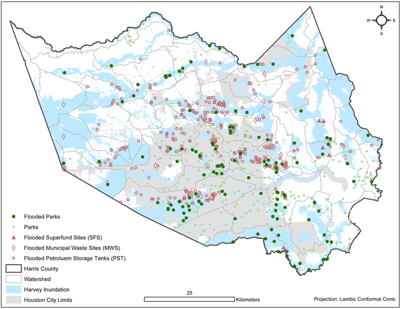
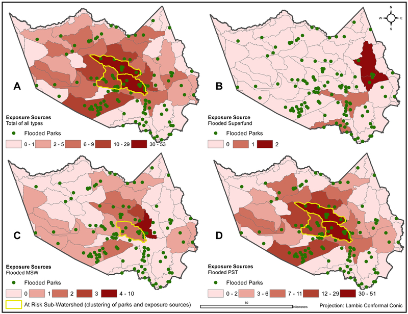
Hurricane Harvey made landfall on the Texas Gulf Coast in August 2017 causing catastrophic flooding. Harris County is highly vulnerable to flooding, which is controlled in part by a system of bayous that include parks and trails. The petrochemical industry, as well as thousands of documented sources of environmental pollution make recreational areas susceptible to environmental contamination during flood events. Recreational areas and toxic exposure sources were geocoded by subwatershed boundaries and overlaid with the area of Hurricane Harvey inundation. A total of 121 of 349 (36.78%) parks were flooded; 102 of 121 (84.30%) were located in subwatersheds with at least one exposure source. A total of 337 exposure sources (6 Superfund, 32 municipal solid waste, and 299 petroleum storage tanks) in 30 subwatersheds were flooded. Though parks provide flood mitigation and other postdisaster benefits, their susceptibility to environmental contamination should be considered, especially in areas with a large number of toxic exposure sources.
Keywords: Environmental exposure; Flooding; GIS; Hurricane Harvey; Parks.
Figures
Similar articles
-
Hurricane Harvey Hospital Flood Impacts: Accuracy of Federal Emergency Management Agency Flood Hazard Areas in Harris County, Texas.Am J Public Health. 2020 Apr;110(4):574-579. doi: 10.2105/AJPH.2019.305520. Epub 2020 Feb 20. Am J Public Health. 2020. PMID: 32078350 Free PMC article.
-
Houston hurricane Harvey health (Houston-3H) study: assessment of allergic symptoms and stress after hurricane Harvey flooding.Environ Health. 2021 Jan 19;20(1):9. doi: 10.1186/s12940-021-00694-2. Environ Health. 2021. PMID: 33468146 Free PMC article.
-
Environmental injustice and Hurricane Harvey: A household-level study of socially disparate flood exposures in Greater Houston, Texas, USA.Environ Res. 2019 Dec;179(Pt A):108772. doi: 10.1016/j.envres.2019.108772. Epub 2019 Sep 25. Environ Res. 2019. PMID: 31593835
-
The Anesthesiologist's Response to Hurricane Natural Disaster Incidents: Hurricane Harvey.Anesthesiol Clin. 2019 Mar;37(1):151-160. doi: 10.1016/j.anclin.2018.09.005. Epub 2018 Dec 19. Anesthesiol Clin. 2019. PMID: 30711228 Review.
-
Environmental health effects attributed to toxic and infectious agents following hurricanes, cyclones, flash floods and major hydrometeorological events.J Toxicol Environ Health B Crit Rev. 2019;22(5-6):157-171. doi: 10.1080/10937404.2019.1654422. Epub 2019 Aug 22. J Toxicol Environ Health B Crit Rev. 2019. PMID: 31437111 Review.
Cited by
-
The projected impacts of smart decline on urban runoff contamination levels.Comput Urban Sci. 2021 Dec;1(1):2. doi: 10.1007/s43762-021-00002-1. Epub 2021 Mar 29. Comput Urban Sci. 2021. PMID: 34888588 Free PMC article.
-
Resident perspectives of environmental health risk exposures after Hurricane Harvey.J Environ Stud Sci. 2021 Dec;11(4):574-585. doi: 10.1007/s13412-021-00674-5. Epub 2021 Mar 19. J Environ Stud Sci. 2021. PMID: 35663127 Free PMC article.
-
Adverse Health Outcomes Following Hurricane Harvey: A Comparison of Remotely-Sensed and Self-Reported Flood Exposure Estimates.Geohealth. 2023 Apr 21;7(4):e2022GH000710. doi: 10.1029/2022GH000710. eCollection 2023 Apr. Geohealth. 2023. PMID: 37091294 Free PMC article.
-
Associating Increased Chemical Exposure to Hurricane Harvey in a Longitudinal Panel Using Silicone Wristbands.Int J Environ Res Public Health. 2022 May 30;19(11):6670. doi: 10.3390/ijerph19116670. Int J Environ Res Public Health. 2022. PMID: 35682254 Free PMC article.
-
Comparing Primary Health-Care Service Delivery Disruptions Across Disasters.Disaster Med Public Health Prep. 2022 Oct;16(5):1802-1805. doi: 10.1017/dmp.2021.213. Epub 2021 Aug 17. Disaster Med Public Health Prep. 2022. PMID: 34399879 Free PMC article.
References
-
- Agency for Toxic Substances and Disease Registry. 2010. “Toxicological profile for ethylbenzene.” Atlanta, GA: U.S. Department of Health and Human Services, U.S. Public Health Service, Agency for Toxic Substances and Disease Registry. - PubMed
-
- Ahern Jack. 2011. “From Fail-Safe to Safe-to-Fail: Sustainability and Resilience in the New Urban World.” Landscape Architecture & Regional Planning Studio and Student Research and Creative Activity, April https://scholarworks.umass.edU/larp_grad_research/8.
-
- Ahmed FE 2001. "Toxicology and human health effects following exposure to oxygenated or reformulated gasoline." Toxicology Letters 123(2-3):89–113. - PubMed
MeSH terms
Grants and funding
LinkOut - more resources
Full Text Sources
Medical
